
'Don't drown': Destructive Cyclone Trevor hits Northern Territory
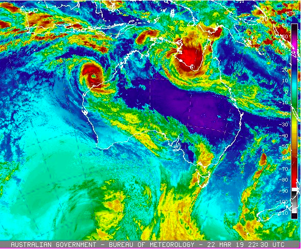
A destructive and intense Cyclone Trevor has hit the Northern Territory mainland, crossing into the remote Gulf of Carpentaria coast as a category four system.
The storm is producing wind gusts of 250km/h as it makes landfall on the coast near the Northern Territory’s border with Queensland from about 9.50am Darwin time (11.20am AEDT) on Saturday.
It was bringing “very destructive” winds of 175km/h at Centre Island, off the coast of Borroloola, according to the Bureau of Meteorology.
Evacuations have ended for communities in the cyclone’s path, including Borroloola, Numbulwar and Groote Eylandt, with authorities now urging remaining residents to prepare for flooding and “very destructive” winds.
Trevor is also expected to produce heavy rain and tidal surges.
The storm core was just south of the Pellew Islands, while the system stretched to Mornington Island in Queensland.
“It looks like the centre of Cyclone Trevor is going to passing fairly close to Borroloola,” bureau forecaster Shane Kennedy told AAP.
The cyclone, moving west southwest at 19km/h, was expected to weaken as it hits the coast and be a category two system by Saturday evening.
NT Emergency Services’ Jason Collins said anyone remaining in Trevor’s path needs to have supplies to last at least three days, take shelter and stay away from waterways.

“Turn around, don’t drown. We may not be there to save you,” he said.
“Emergency services are stretched.”
By Sunday afternoon, forecasters believe Trevor will weaken below cyclone strength and reach Tennant Creek, 1000km south of Darwin, as a tropical low in the evening.
“It’s going to take quite a while to weaken because it is quite a physically large system and intense system at the moment,” Mr Kennedy said.
“It is expected when it moves to land to start weakening, definitely.”
But probably at least this time tomorrow, it’s still likely to be cyclone-strength, producing gale force winds over water and tracking a fair way inland.”
He said Groote Eylandt communities had been “spared the brunt of it”, with the less inhabited south of the island experiencing strong winds.

Trevor left behind a trail of damage in Queensland’s Cape York Peninsula earlier this week, uprooting trees, causing flooding and roof damage, closing schools and roads, and knocking out power supplies.
Inland locations such as Queensland’s Burketown and Doomadgee, as well as McArthur River in the Northern Territory, have been warned of gales.
Residents in Borroloola, Ngukurr and Numbulwar have been told to expect disruptions to their water supply.
Meanwhile, tropical cyclone Veronica is expected to bring gales to Western Australia’s Pilbara as it tracks slowly east towards the coast on Saturday.
The category four system was 270 kilometres off Port Hedland, with a warning in place for residents between Wallal Downs and Mardie for wind gusts of 100km/h, and heavy rainfall bringing the risk of major flooding.
Communities in the Pilbara have been urged to prepare to shelter.
Do you know more or have a story tip? Email: y7newsroom@yahoo7.com.au.
You can also follow us on Facebook and Twitter and stay up to date with the latest news with Yahoo7’s daily newsletter. Sign up here.


