
Fire and ice: Australian states brace for extreme weather
Extreme winds across several south-east Australian states have prompted the Bureau of Meteorology to issue a number of severe warnings.
While southeast Queensland and NSW are bracing for severe fire danger as temperatures close to 40C are forecast for Friday, parts of Tasmania that just saw wildfires awoke to snow to Thursday thanks to a polar blast.
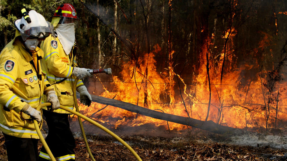
Emergency warnings for NSW bushfires
Residents in parts of the NSW mid-north coast have been urged to seek shelter as bushfires approach their homes, with hot and strong winds fanning flames.
Four emergency warnings were in place on Thursday evening for blazes at Forster, Stockyard Flat, inland from Port Macquarie, Hillville, near Taree, and Rumba Dump in the Tapin Tops National Park .
Earlier emergency warnings for Wandsworth, north of Armidale and Gulf Road in Torrington, north of Inverell, had been downgraded to less serious "watch and act" alerts. Fires at Bills Crossing Crowdy, just east of Taree remained at that level.
The nine-hectare Forster blaze, in the Goldens Road area, has broken containment lines on the eastern side of The Southern Parkway.
The RFS says people in the Goldens Road, The Southern Parkway and north of Cape Hawke Drive, should seek shelter as the fire approaches and protect themselves from the heat.
The Hillville fire, meanwhile, is burning in the Talawahl Nature Reserve, in an easterly direction toward the Pacific Highway.
Residents in the Possum Brush Road and Talawahl areas are also advised to seek shelter when the blaze approaches, while those in Hallidays Point or Corrigan should be aware of smoke and embers.
The fire at Stockyard Flat is burning across more than 4000 hectares with residents in the area of Blomfield Road encouraged to seek shelter.
The Rumba Dump fire is nearly 1300ha in size and people around Caparra Road and Hardway Creek Road are urged to seek shelter.
Seven total fire bans are in place for Thursday and emergency services have warned people to take care, with a forecast high of 37C in Grafton.
Some 66 fires are burning across NSW, with 19 uncontained.
The RFS said strong westerly winds are blowing dust across much of the state's northeast, and the Central Coast and Newcastle areas are likely to endure hazy conditions over the coming days.
Total fire bans are in place in the far north coast, north coast, Greater Hunter, Greater Sydney, New England, northern slopes and northwestern regions.
There is also a very high fire danger rating in Illawarra/Shoalhaven, Monaro Alpine, the southern ranges and central ranges.
The warm, dry and windy conditions are expected to continue into Friday.
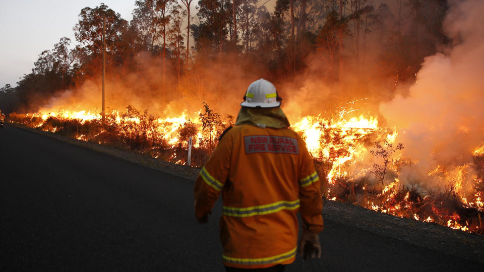
Extreme fire danger as temps soar in Queensland
The severe conditions forecast for Friday have prompted extreme fire danger warnings and fire bans across much of Queensland.
Wind gusts of up to 80km/h are expected in the afternoon as a low-pressure trough sweeps across the southeast, the weather bureau says.
Brisbane is set to reach a maximum of 37C while Ipswich will sizzle in 39C heat with no chance of rain over the next week.
Extreme fire dangers will peak in the Darling Downs and Granite Belt with warnings also issued for the Maranoa, Warrego, the Central Highlands and Coalfields, Wide Bay and Burnett regions and the southeast coast.
"We are expecting the worst of those conditions to be felt throughout the southeast interior tomorrow (Friday) with temperatures raised six to 10 degrees above average at this time of year," forecaster Kimba Wong said.
"It is a severe start to the fire season with conditions worse than last year."
🔥 We're calling on Queenslanders to be on alert with severe and extreme fire conditions expected over the coming days. 🔥
✔️Stay up-to-date with bushfire warnings
✔️Ensure your preparations are in order, including your Bushfire Survival Plan
✔️ Report fires to Triple Zero (000) pic.twitter.com/Wjylfsnb7d— Qld Fire & Emergency (@QldFES) November 7, 2019
Bushfires are already burning across Queensland on the Darling Downs near Laidley, and south of Gympie.
No evacuations had been ordered on Thursday, but residents are warned to remain on alert for Friday's extreme conditions.
Conditions will ease over the weekend, but the fire warning remain in place.
Severe winds for most of Victoria
An extreme weather warning has also been issued to large parts of Victoria.
The BOM issued a warning on Thursday afternoon for “damaging westerly winds” of up 100 km/h for the Grampians region in the state’s west and also over the Alpine areas in eastern Victoria.
Rain moving across #Melbourne city at the moment is starting to fill up those gauges. Be careful out there, and let us know what rainfall totals you're getting at your place! 🌧️🌧️🌧️ https://t.co/GER7hbDQYL pic.twitter.com/CBr3XO8odn
— Bureau of Meteorology, Victoria (@BOM_Vic) November 7, 2019
Wind was expected to gradually ease during the early hours of Friday morning, while showers and thunderstorms were strongly predicted for most districts.
Spring snow covers Tasmania bushfire zone
November snow has fallen in parts of Tasmania, including in the state's Central Highlands where last week a bushfire threatened shacks.
Springtime snow has blanketed parts of Tasmania, including in the state's centre where bushfires raged a mere week ago.
Tourists and residents at Miena in the Central Highlands woke on Thursday morning to a thick covering of snow.
"White - there's no other way to describe it. It's beautiful," Great Lake Hotel general manager Rob Morton said.
"We've had a couple of campers that had a bit of a shock overnight, but we got them into the hotel and warmed them up."
The cold front follows a wildfire that threatened shacks near Miena in late October when authorities declared the official start of the bushfire season.
But on Thursday morning temperatures at nearby Liawenee dropped below zero.
Tasmania this morning pic.twitter.com/bgGwWvA0fB
— Stevo (@RedonBlack1872) November 6, 2019
Hobart's Mt Wellington had a dusting of snow on its peak and there were also falls at Mt Field.
Bureau of Meteorology meteorologist Luke Johnson said snow was uncommon in November.
"It certainly doesn't happen every day. But this time of year we can see it," he said.
"All it needs is a decent burst of cold air, which does happen from time to time."
Snowfall levels are expected to drop even lower from Thursday's 700m to 500m on Friday.
"It'll be snowing down to low levels but the ground, particularly at lower elevations, will be quite warm. It's unlikely that snow will settle on anything but the higher peaks," Mr Johnston said.
A severe weather warning for damaging wind gusts of more than 100km/h is in place for the state's south.
Winds are expected to ease on Thursday night but cooler temperatures will persist into the weekend.
–– With AAP
Do you have a story tip? Email: newsroomau@yahoonews.com.
You can also follow us on Facebook and Twitter, download the Yahoo News app from the App Store or Google Play and stay up to date with the latest news with Yahoo’s daily newsletter. Sign up here.

