
Severe weather warnings in place as two states set to be hit by cyclone

Tropical cyclone Esther has formed in the Gulf of Carpentaria, north of Mornington Island near the Queensland and Northern Territory border with winds of up to 130km/h expected.
Residents of two states were battening down the hatches as the slow-moving tropical low threatened to develop into Cyclone Esther overnight.
The tropical low in the Gulf's centre was predicted to strengthen into a category 1 system overnight, the Bureau of Meteorology said, which has now occurred.
“The tropical low has resumed its southward movement over the Gulf of Carpentaria east of Groote Eylandt,” the bureau said in a note on Sunday evening.
“It should continue to move southward and intensify and develop into a tropical cyclone tonight or early Monday morning.”
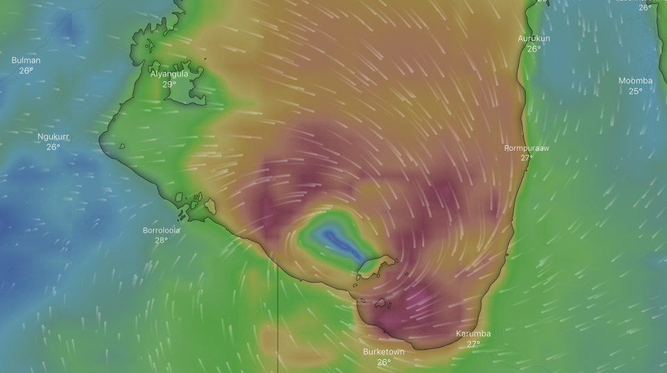
Shortly after 5:30am Monday morning, the Bureau of Meteorology Queensland said the system had developed into a category 1 cyclone.
The cyclone is producing wind gusts up to 110 kilometres per hour which could strengthen as it moves southwest at about 10 kilometres an hour.
People from Port Roper to the NT and Queensland border and surrounding areas should activate their household plan now, authorities said. “Start preparations for a cyclone, know where you will shelter.”
Those near Burketown, including Mornington and Sweers Islands and Doomadgee, should remain inside until the cyclone has passed and keep up with the latest advice.
Earlier on Sunday night, forecasters predicted the system could briefly turn into a category 2 cyclone as it hits the coastline and makes landfall between Borroloola and Mornington Island about lunchtime on Monday.
“Sometime in the early afternoon it will probably cross the coast, at this stage as a category 2,” a bureau spokesman told AAP.
However at 4am this morning, the bureau said “a category 2 impact is considered unlikely”.
Tropical cyclone Esther has formed in the Gulf of Carpentaria, north of Mornington Island. For the latest #CycloneEsther updates, refer to https://t.co/rVLE6i5J4y pic.twitter.com/7YsBwe4QQR
— Bureau of Meteorology, Queensland (@BOM_Qld) February 23, 2020
Heavy rain with the potential to cause flash flooding is expected in areas around the Gulf of Carpentaria over the next couple of days, forecasters say.
The region could receive up to 200 millimetres of rain west of Burketown to the Northern Territory border on Monday with the downpours continuing as the system slowly moves across the Top End.
“It will weaken after crossing the coast but we are expecting significant rainfall,” meteorologist Shane Kennedy said.
Flood warnings are current for Gulf of Carpentaria catchments with more than 400mm of rain potentially falling within 48 hours.
There is a severe weather warning out for the gulf right up to the Torres Strait.
Abnormally high tides are expected to swamp the coast with large waves causing minor flooding.
Destructive winds with gusts up to 130km/h are possible in coastal areas between Borroloola and Mornington Island early on Monday as the system approaches.
The slow-moving system is expected to weaken as it moves toward the central Northern Territory before possibly affecting Western Australia later in the week.
Forecasters say the system could strengthen after passing over Western Australia and the cyclone may reform in the southern Indian Ocean and possibly make a second landfall on the Pilbara coast later in the week.
Meanwhile, a tropical low north of the WA coast is forecast to develop into a tropical cyclone today.
The system is well off the coast at 660 kilometres northwest of Broome and moving southwest at eight kilometres per hour. As of 3am Monday there was no tropical cyclone advice issued.
with AAP
Do you have a story tip? Email: newsroomau@yahoonews.com.
You can also follow us on Facebook, Instagram and Twitter and download the Yahoo News app from the App Store or Google Play.


