
Heavy downpour to pummel east coast with a month's worth of rain in one week

Parts of Queensland and NSW could see flash flooding over the next week as Australia’s east coast is lashed with heavy rain and thunderstorms.
An easterly air stream carrying moisture from the Tasman Sea will bring as much as 200mm of rain to the Queensland and NSW border region in the coming days – more than a month’s worth of rain in just one week.
On Wednesday and Thursday, the heaviest falls are expected on the Sunshine Coast, north of Brisbane, with rain also forecast for the drought-affected southern interior and southwest of the state.
Southern interior areas including the Southern Downs, Darling Downs and parts of the Warrego and Maranoa regions could see up to 40mm each day until the weekend.
"Given how dry it has been in those areas this could be the most significant rainfall the southern interior of Queensland has seen in a number of months," bureau meteorologist Harry Clark said.
Forecast rain should put out some fires
Sky News Weather chief meteorologist Tom Saunders said as of Thursday he expects NSW’s inland towns will receive 100mm of rain, with 50mm falls widespread across coastal cities.
“For Sydney it should be the wettest week since at least march last year,” he said.
The rainfall is expected to reach areas that have been ravaged by drought and fire.
Roughly 60 bushfires were still burning across NSW on Wednesday morning, but only a handful should remain after the heavy rain, Mr Saunders said.

However, BOM meteorologists have warned such areas are “particularly vulnerable to rainfall runoff, which will be enhanced, and also possible landslides”.
Flash flooding likely near NSW-QLD border
A flood warning has been issued for coastal catchments south of Maryborough near the Queensland and NSW border.
Parts of the NSW Northern Rivers and Southeast Queensland will be subject to flash-flooding with up to 100mm likely to fall in the region on Thursday.
A second minor flood warning has been issued for Paroo River in NSW, which will likely peak near 1.8meters on Wednesday. The river is expected to reach 2.6metres this weekend.
Heavy rainfall drenched Western Australia’s northwest coast on Tuesday, bringing 100mm of rain in just 24 hours.
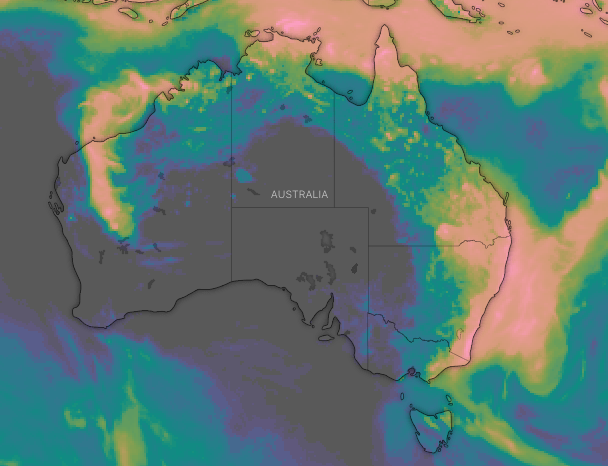
Our 8 day rainfall accumulation map indicates rainfall across much of the country (apart from SA 😞). Heavy falls forecast for northern Australia, particular off the north coast of WA (with a developing Tropical Cyclone) and also about the east coast ☔ https://t.co/4W35o8i7wJ pic.twitter.com/2wVdlmSLTX
— Bureau of Meteorology, Australia (@BOM_au) February 4, 2020
Cyclone heading for WA’s Pilbara coast
A tropical low is forming over the area and is expected to develop into a tropical cyclone on Thursday. It is forecast to cross the coast on the weekend.
“During Friday, the tropical cyclone is forecast to turn towards the Pilbara coast and intensify before crossing the coast over the weekend,” the bureau warned.
“A severe tropical cyclone impact is possible along the Pilbara coast between Exmouth and Port Hedland, including Karratha, over the weekend.”
However, a monsoon trough off in the Coral Sea could also lead to the season's first cyclone.
Conditions for a cyclone are likely to become favourable by early next week, according to a statement issued by the bureau.
with AAP
Do you have a story tip? Email: newsroomau@yahoonews.com.
You can also follow us on Facebook, Instagram and Twitter and download the Yahoo News app from the App Store or Google Play.


