
Mapped: Hurricane Beryl powers through Caribbean islands as Category 3 storm
Hurricane Beryl is barreling towards Mexico and possibly the US, after tearing through Jamaica and the Windward Islands, bringing devastating winds and storm surges that have destroyed homes, wiped out power, and left at least eight people dead.
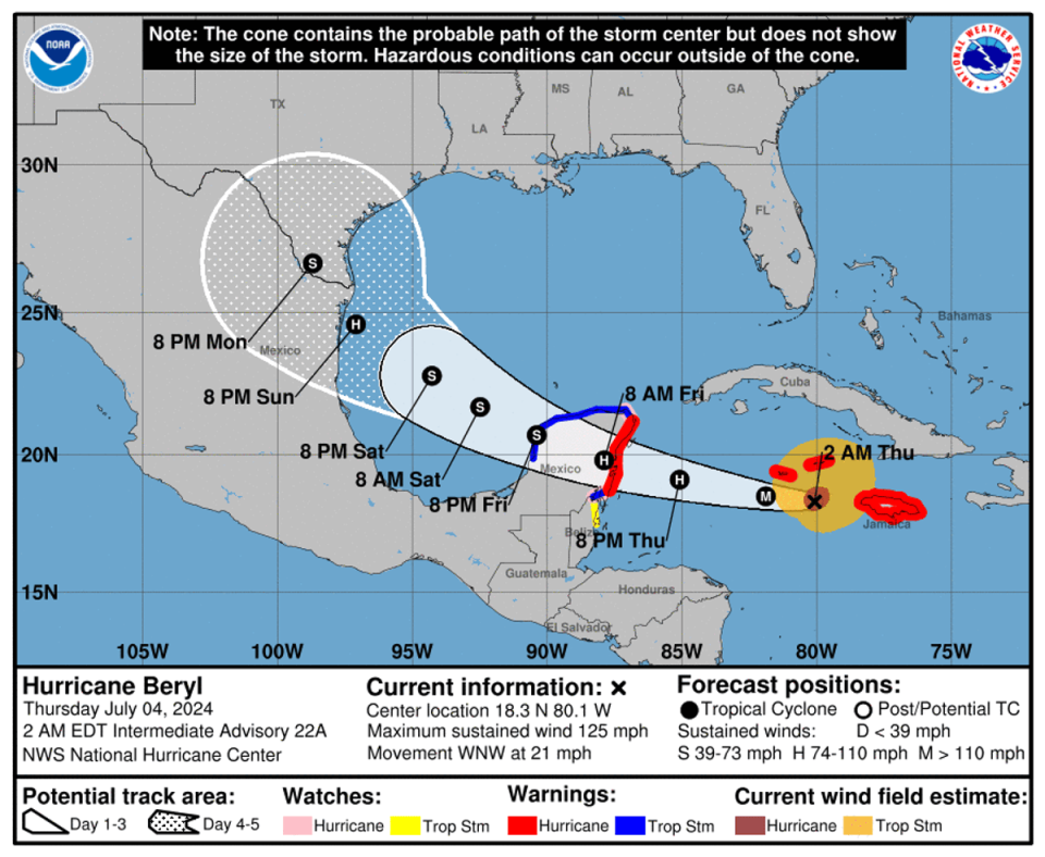
The storm continues to be a “major hurricane” after it got downgraded to Category 3 hurricane on Thursday morning, packing maximum sustained winds of 120mph (195kph).
Follow our live coverage of Hurricane Beryl here.
Beryl charted a deadly path through Jamaica, Grenada and St Vincent and the Grenadines, destroying buildings and killing at least eight, including one in Jamaica and three in Venezuela where outer rings of the hurricane caused heavy rainfall.
On Thursday morning, winds and rainfall from the hurricane were still battering Jamaica as prime minister Andrew Holness extended the curfew till 6am.
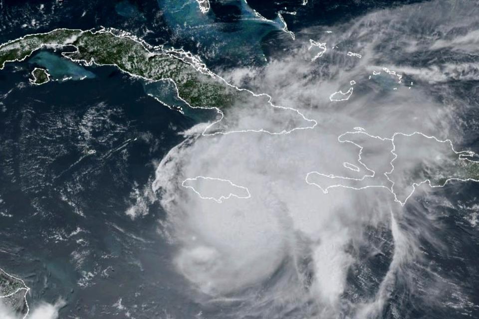
After Jamaica, the hurricane was passing through Caymon Islands and heading towards Yucatan Peninsula and Belize on Thursday.
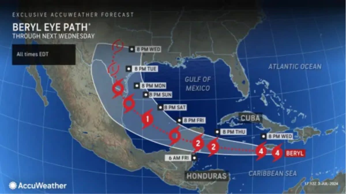
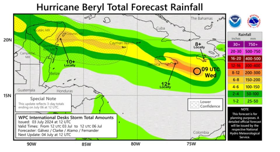
Beryl was forecast to weaken slightly over the next day or two, but still be at or near major-hurricane strength when it enters and into Mexico’s Yucatan Peninsula late Thursday or Friday, according to the US National Hurricane Centre.
Officials in Mexico warned the storm can make a “rare” double strike.
Laura Velazquez, the head of Mexico’s civil defence agency said the hurricane is expected to make landfall along a relatively unpopulated stretch of the Caribbean coast between Tulum and the inland town of Felipe Carrillo Puerto.
Because the coast there is largely made up of lagoons and mangroves, there are few resorts or hotels in the area south of Tulum.
The hurricane is expected to weaken to a tropical storm as it crosses the Yucatan peninsula and re-emerge over the weekend at storm strength into the Gulf of Mexico.
Ms Velazquez said that Beryl is then expected to hit Mexican territory a second time in the Gulf coast states of Veracruz or Tamaulipas, near the Texas border.
If Hurricane Beryl maintains its strength, it has the potential to hit southern Texas and Louisiana over the weekend, according to the National Weather Service.
Earlier, Beryl beat records, first becoming the earliest Category 4 hurricane and later the earliest Category 5 hurricane in the Atlantic.

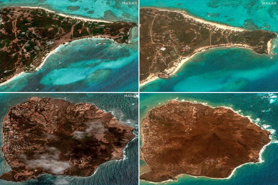
Officials in the Windward Islands, where Beryl first made landfall received “widespread reports of destruction and devastation in Carriacou and Petite Martinique”, Grenada prime minister Dickon Mitchell said.
“In half an hour, Carriacou was flattened.”
A total of eight deaths have been confirmed, with Jamaica confirming first death on Thursday and four dead in the Windward islands, including one person who was killed in Grenada’s capital St George’s, when a tree fell on a house.
Three deaths were reported in Venezuela where rainfall from outer rings of Hurricane Beryl caused flooding and landslides.
“We do hope there aren’t any other fatalities or any injuries,” said Mitchell. “But bear in mind the challenge we have in Carriacou and Petite Martinique.”
Authorities were scrambling to assess the situation on the islands of Carriacou and Petite Martinique, where there were initial reports of major damage but communications remained a challenge, he said.
On the Grenadine island Union Island, around 90 per cent of homes have been damaged or destroyed, he said.
Beryl is now only the second storm on record to reach the intensity of Category 5 in July, after Emily did so in mid-July 2005.
Earlier on Sunday, it became the earliest storm to reach Category 4 and the first ever to do so in June.
The hurricane was downgraded Sunday evening to a Category 3, but picked up power and speed over warm ocean water and was upgraded to Category 4 on Monday morning.
With the hurricane hitting St Vincent and the Grenadines over the carnival weekend, prime minister Ralph Gonsalves on Sunday urged residents to postpone their festivities and prepare for Beryl to hit.
Mr Gonsalves has already ordered the early closure of bars and postponed some carnival events, according to Loop News.
Airports were also shuttered including in Barbados, Grenada, and St Lucia on Sunday night in preparation for the storm, however, Grenada’s Maurice Bishop International Airport reopened on Tuesday.
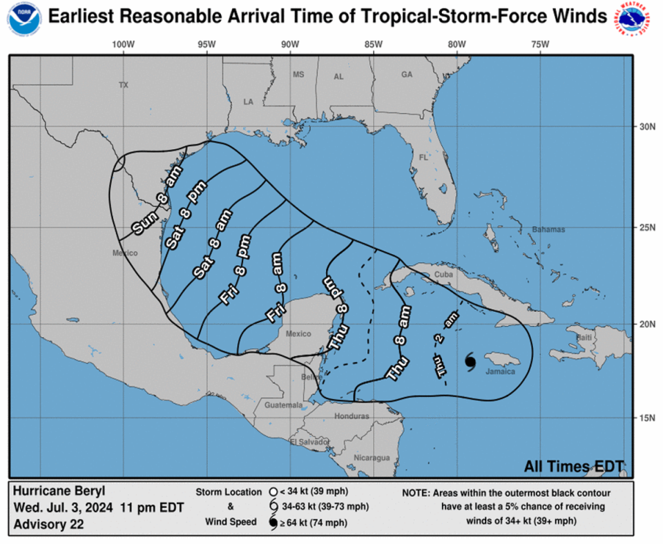
The storm is expected to remain a major hurricane as it moves through the Caribbean, with a Tropical Storm watch in effect for the south coast of Hispaniola.
A Hurricane Watch was also in effect on Tuesday for Grand Cayman, Little Cayman and Cayman Brac and the coast of the Yucatan Peninsula of Mexico from Puerto Costa Maya to Cancun, including Cozumel.
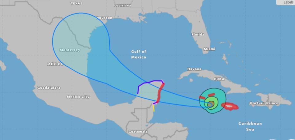
After making landfall in Mexico, Beryl is forecast to weaken. But a computer model of Hurricane Beryl’s many possible paths, known as a “spaghetti” model, showed the direction the destructive storm could take as it moved towards the southeastern US in bathtub-warm waters of the Gulf of Mexico.
The model showed the storm potentially blowing into the Gulf Coast, near eastern Texas and Louisiana.
Global heating, caused by burning coal, oil and gas, has been increasing temperatures on land and the ocean. Warmer ocean waters fuel hurricanes. The area where Beryl is located, ocean temperatures are 2 to 3 degrees above normal for this time of the year, the levels that aren’t typically seen until September.

