
Disturbing map reveals trend that 'primed' Australia for bushfire crisis

Alarming graphics of Australia have been released detailing the lack of rainfall across the nation – with large parts recording their lowest rainfall on record which “primed” parts of the country for the bushfire crisis.
December rainfall was the lowest on record across Australia, the Bureau of Meteorology confirmed on Wednesday.
One map depicting rainfall deficiency in the five months between August and December showed most of Queensland and NSW had either suffered a severe deficiency or their lowest on record.

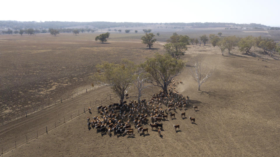
A lack of rain has proven devastating for the two states’ rural and urban dwellers which have been ravaged by drought and has fuelled the ongoing bushfire crisis in southeast Australia.
Storage volumes have rapidly decreased in major cities across the east, which prompted Sydney’s Level Two water restrictions in December.
Photos from Sydney’s Centennial Park on Tuesday highlighted the harsh reality of no significant rain.

Sydney’s water storage levels sit at their lowest in years – 43.6 per cent. This time last year they were at 60.9 per cent.
When assessing the nation’s rainfall for 2019, 68 per cent of the country endured rainfall totals in the lowest 10 per cent on record.
Twenty-four per cent of the nation suffered its lowest on record for 12 months.
The year 2019 received more than 30 per cent less rain than the previous low.
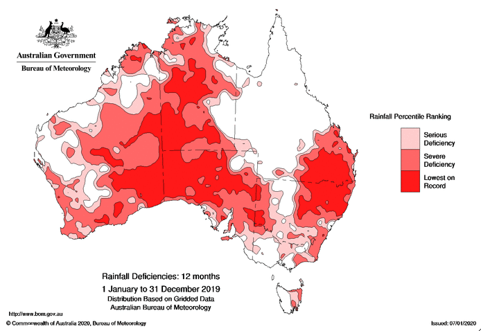
Northern NSW, southern Queensland, vast areas of South Australia and the NT, and southeast Western Australia all suffered significant lack of rain.
Firie's exhausting hours before outburst at prime minister revealed
'You have been warned': Fire-ravaged town leaves ominous message to looters
The Murray-Darling Basin has also been hit hard. Some of the largest rainfall deficiencies have occurred in the upper catchments of some of the major tributaries of the Darling, including the Macquarie, the Namoi–Peel, and the Border Rivers.
Rain-blocking conditions returns to normality
The Indian Ocean Dipole (IOD), which is the difference in temperatures between the eastern and western sides of the Indian Ocean, has finally returned to neutral after a prolonged period of a positive IOD.
The Bureau of Meteorology said the latter half of 2019 was “one of the strongest positive IOD events to impact Australia in recent history.”
And despite it returning to normal, the damage has already been done in terms of drought and bushfire danger.
“The IOD’s legacy of widespread warm and dry conditions during the second half of 2019 primed the Australian landscape for bushfire weather and heatwaves this summer,” the Bureau of Meteorology said.
The neutral IOD will last into autumn meaning there will be little relief when it comes to prolonged, much needed rain.
The Bureau of Meteorology said “consistent, widespread, above average rainfall over several months” is needed to lift the country out of the drought.
Do you have a story tip? Email: newsroomau@yahoonews.com.
You can also follow us on Facebook, Instagram and Twitter and download the Yahoo News app from the App Store or Google Play.


