
Heat relief! Cold front brings severe storms and cool change

A cold front arrived in Sydney on Wednesday afternoon bringing severe thunderstorms, damaging winds and steep drops in temperatures.
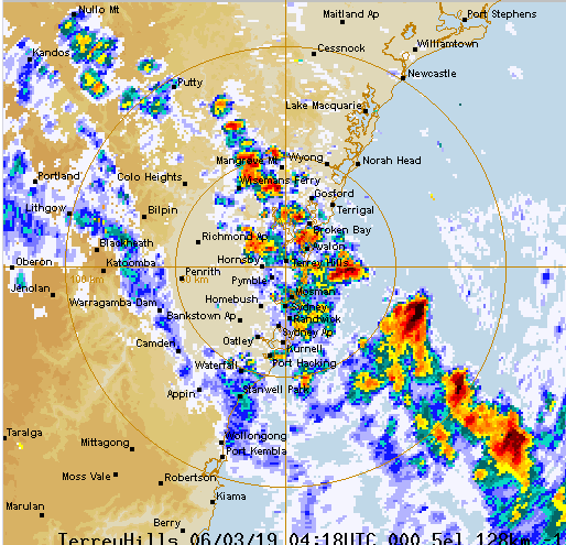
The Bureau of Meteorology issued a severe thunderstorm warning for damaging winds for parts of Sydney on Wednesday.
The storms were moving towards the southeast impacting on Parramatta, Sydney Airport and Sydney Olympic Park areas at 2:40pm, with Sydney’s CBD and waters off Bondi Beach set to be affected by 3.10pm, according to the warning.
It extends to metropolitan, Central Tablelands and parts of Hunter, Illawarra, North West Slopes and Plains, and Central West Slopes and Plains areas.
“We’re seeing at this stage temperatures have dropped six to seven degrees through Sydney, in most parts over the last 45 minutes or so,” BoM meteorologist Craig Ryan told Yahoo7.
Sydney reached a top temperature of 34.2 degrees at 1:30pm and had dropped to 25.7 two hours later.
Mr Ryan added Wednesday’s dusty haze would also lift as cold front conditions push through.
Cooler temperatures will carry on into Thursday.
View this post on Instagram
A post shared by Karen Mc (@kazzi1965) on Mar 5, 2019 at 8:06pm PST
View this post on Instagram
A post shared by Kieran (@aintnoslr) on Mar 5, 2019 at 7:53pm PST
“We’re looking at 24 degrees (in the metro area) and out towards Penrith, it’ll be 26,” Mr Ryan said.
“Throughout the [Sydney] basin temperatures will be around 10 degrees cooler than we were forecasting for today (Wednesday’s predicted maximum was 35C).”
Up to 10mm of rainfall is expected in the Sydney area on Wednesday.
Mr Ryan said wind gusts of up to 70km/h were expected.
