
Monster storm arrives as Australia's southeast braces for heavy wind, snow and rain
Millions of Australians are bracing themselves for a cold blast set to punish the nation’s southeast over the coming days.
Residents across South Australia, Victoria, NSW, the ACT and Tasmania will shiver through the “strongest weather system this winter” that will last right through to Sunday.
BoM Meteorologist Dr Adam Morgan said temperatures across Australia’s southeast will dip up to 8 degrees below the average for August, starting on Thursday.
Social media was already awash with photos and video of heavy snowfall across alpine regions.
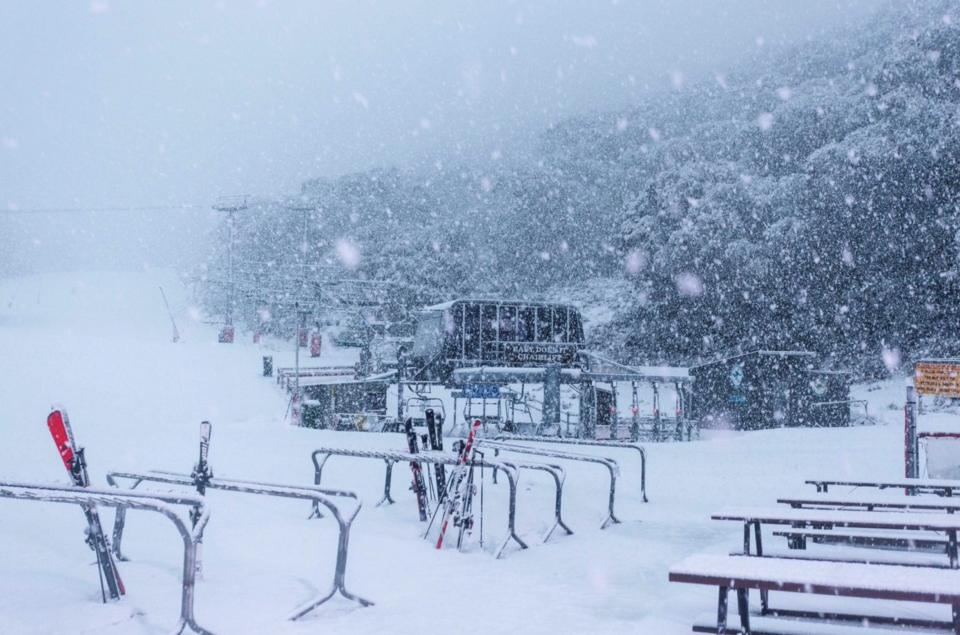
Victoria’s Mount Hotham and Falls Creek were blanketed by several inches while similar scenes were present at Thredbo and Perisher resorts in NSW.
One resort at Dinner Plain, next to Mt Hotham in Victoria, described the snow as a “massive dump”.
Snow to reach several areas including western NSW
Dr Morgan said up to half a metre was expected in alpine regions as blizzards batter the southeast.
Snow is expected to fall in areas as low as 400 metres and is expected to fall further north in areas including the NSW Central West and hills around Canberra on Friday.
Snowfalls are likely in the Blue Mountains west of Sydney on Saturday and snow may even fall close to the Queensland border in the Northern Tablelands.
BoM Meteorologist Michael Logan said there would be “widespread and damaging” winds across the mainland over the next few days, starting in South Australia on Thursday.
A series of severe weather warnings have been put in place in preparation for the extreme weather, including a warning to farmers to protect their livestock to prevent loss of life.
Canberra shivers through -3.5 degrees
Canberrans can expect to freeze for the next couple of days. The temperature got down to -3.5 in the nation’s capital early on Thursday morning.
At Melbourne Airport the temperature dipped to 5 degrees. In the west of Sydney it was just 2.5 at Penrith just before 7am on Thursday.
In Tasmania, the temperature in Launceston overnight dropped to just 0.2, while Hobart was 2 degrees early on Thursday morning.
"The cold air will extend up through NSW right across the weekend, with fairly widespread damaging winds, including Sydney, Wollongong and populated parts of the east coast," spokesman Michael Logan said.
Sydney will experience a low of 8 degrees on the weekend and 3 degrees in the west.
Victoria to face 120km/h destructive winds
Victorians have been warned to prepare for damaging winds of up to 120km/h, as a strong cold front crosses the state.
Blizzards began in the alpine region around dawn on Thursday and will continue through much of the night and into Friday morning, the Bureau of Meteorology says.
Winds will average 60 to 70km/h, with peak gusts of 90 to 100km/h, but alpine regions above 1200 metres could experience winds up to 120km/h.
The cold snap will reach western Victoria late in the afternoon before crossing the remainder of the state into Friday morning.
Warning to move vehicles under cover
Residents from Mildura, Horsham, Warrnambool and Bendigo, through to Shepparton, Seymour, Ballarat, Geelong, Melbourne, and alpine ski resorts can expect to be affected by the wintry blast.
The State Emergency Service advises people to move vehicles under cover or away from trees, secure loose items and keep clear of fallen power lines.
Melbourne temperatures are expected to reach a measly 11 degrees across Friday and Saturday.
The bureau says large parts of Victoria will cop half a month’s worth of rain over the next few days.
Although rain is falling across much of Victoria, gusty westerly winds have reduced visibility to 2000m in blowing dust at Mildura. The highest rainfall totals since 9am are 25mm at Matong North (Ovens river catchment) and 20mm at Nhill in the Wimmera. https://t.co/ZjiDlW7tZv pic.twitter.com/nX39HM7DyH
— Bureau of Meteorology, Victoria (@BOM_Vic) August 7, 2019
South Australia cops brunt of cold snap
Damaging winds and rain are sweeping across a broad area of South Australia bringing warnings of dangerous road conditions, rough seas and high coastal swells.
The Bureau of Meteorology says areas from Ceduna, on the west coast, to Renmark in the Riverland will feel the brunt of the intense weather system.
"This is due to a cold front linked to a low to our south which will also bring with it squally showers and possible thunderstorms and small hail," bureau acting state manager Catherine Kennedy said.
Wet and windy conditions developing over southern SA today. A cold front is forecast to reach Adelaide late morning or early afternoon. The strongest winds and heaviest rainfall expected between about midday and early evening. Severe Weather Warning at https://t.co/uHcfD3cfqE pic.twitter.com/ZPv7cEU6Js
— Bureau of Meteorology, South Australia (@BOM_SA) August 7, 2019
"Conditions will be hazardous about southern coastal areas with rough seas and heavy swells expected with significant wave heights of five to seven metres."
Mount Lofty near Adelaide dropped to 3.5 on Thursday morning.
The bureau said Adelaide would feel the worst of the winds and rain from midday on Thursday and into the evening.
In the Adelaide Hills, rainfall could reach 40 millimetres with about 20 millimetres expected in the city.
Temperatures in Stirling will plummet to a minimum of 4 degrees on Saturday.
The State Emergency Service also urged motorists to be careful on the roads and remain vigilant for changing conditions.
With AAP
Do you have a story tip? Email: newsroomau@yahoonews.com.
You can also follow us on Facebook, download the Yahoo News app from iTunes or Google Play and stay up to date with the latest news with Yahoo’s daily newsletter. Sign up here.

