A wet year boosted California's groundwater, but not enough to address long-term declines

After years of pervasive declines, groundwater levels rose significantly in much of California last year, boosted by historic wet weather and the state’s expanding efforts to replenish depleted aquifers.
The state’s aquifers gained an estimated 8.7 million acre-feet of groundwater — nearly double the total storage capacity of Shasta Lake — during the 2023 water year that ended Sept. 30, according to newly compiled data from the California Department of Water Resources.
A large portion of the gains, an estimated 4.1 million acre-feet, came through efforts that involved capturing water from rivers swollen by rains and snowmelt, and sending it to areas where the water percolated into the ground to recharge aquifers. The state said the amount of managed groundwater recharge that occurred was unprecedented, and nearly double the amount of water replenished during 2019, the prior wet year.
Still, the increase in underground supplies follows much larger long-term declines, driven largely by chronic overpumping in agricultural areas. The gains only partially recouped the estimated losses of 14.3 million acre-feet of groundwater during the previous two years of severe drought, when farms relied heavily on wells and aquifer levels plummeted.
“It was a good bounce up,” said Steven Springhorn, a supervising engineering geologist at the state Department of Water Resources.
“However, we're in a large groundwater deficit,” Springhorn said. “Overall, the trend has been down for a long time.”
The Department of Water Resources released the information in its semiannual report on groundwater conditions. The report did not include data for late 2023 and early 2024, which will be assessed in the next update later this year.
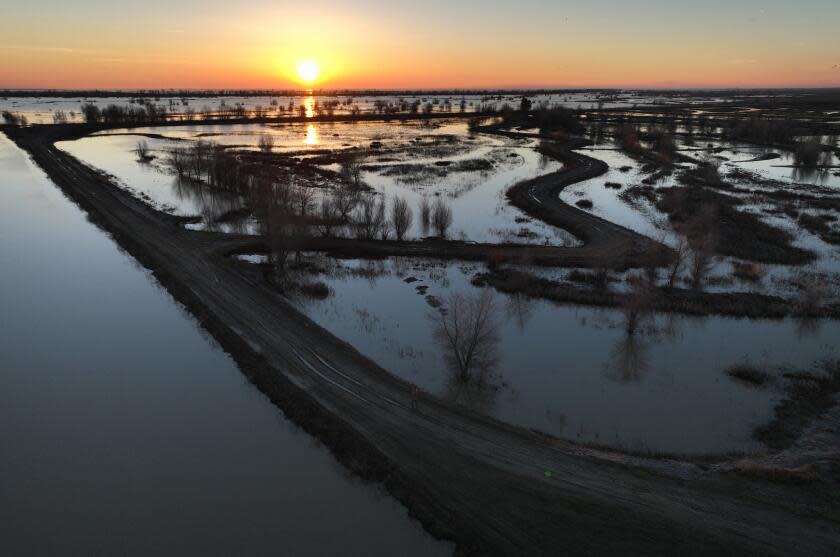
In early 2023, a series of powerful storms ended three years of extreme drought, triggering flooding and leaving one of the largest accumulations of snow on record. The year ranked as the eighth wettest statewide in the last half a century.
The wet weather and the availability of water delivered in canals led agricultural well owners to pump less groundwater. The floodwaters spread out and naturally replenished the groundwater along rivers and wetlands. In some areas, local water agencies directed floodwaters to dedicated recharge basins or farm fields, where water percolated into the ground.
Most of the managed recharge efforts to date have occurred in farming areas of the San Joaquin Valley, where local agencies have been working on plans to combat overdraft and have made investments in infrastructure to transport water to recharge facilities.
Read more: Amid soaking storms, California turns to farmland to funnel water into depleted aquifers
According to the report, water levels rose by more than 5 feet in 52% of wells with available data, while there was little change in 44% of wells, and only 4% of wells declined by more than 5 feet.
Over the last five years, however, most areas have seen declining trends in water levels. The report’s authors said this “underscores the fact that a single year, or even a few years, of heavy precipitation is not enough to refill the state’s depleted groundwater basins” or make up for a series of critically dry years.
Springhorn pointed out that researchers have estimated the losses of groundwater in the Central Valley at roughly 40 million acre-feet over the last two decades.
Since 2000, California has also received much less precipitation than the 20th century average. State water officials call this the “accumulated precipitation deficit,” reflecting repeated droughts and the worsening effects of climate change.
Read more: Groundwater depletion is worsening worldwide. Parts of California are suffering rapid declines
Farms in the Central Valley have long depended on a mix of river water and groundwater to produce crops such as almonds, pistachios, grapes and hay to feed dairy cows.
Declining groundwater levels have left thousands of families with dry wells over the last decade. But after 1,494 dry wells were reported in the 2022 water year, the total fell to 669 dry wells the following year, and has continued declining.
The problem of sinking ground, which is linked to declining groundwater, also eased substantially. Land subsidence affected smaller areas. Between October 2022 and October 2023, areas totaling about 800 square miles — largely on the west side of the San Joaquin Valley — saw a measurable “uplift” of the ground surface of more than 1.2 inches.
Springhorn said local agencies’ efforts to boost groundwater had a positive effect.
“These numbers are great. And they really are reflective of a tremendous amount of work at the local level,” he said. “But there is still a lot more work to be done to reach sustainability in our groundwater basins."

He noted that California will mark the 10th anniversary of the Sustainable Groundwater Management Act this year. The landmark law requires local agencies in many areas to develop groundwater plans and curb overpumping by 2040.
In January, the Department of Water Resources finished reviewing local agencies’ groundwater plans.
State officials have declared those plans inadequate in six areas of the San Joaquin Valley, and last month regulators voted to place one of those regions — the Tulare Lake subbasin — on “probationary” status for failing to adopt sufficient measures to address chronic overpumping.
Some of the areas where the state has declared serious problems of overdraft, such as the Tule and Kaweah subbasins, are also among the regions that did the most aquifer recharge during the last year.
“The impressive recharge numbers in 2023 are the result of hard work by the local agencies combined with dedicated efforts from the state, but we must do more to be prepared to capture and store water when the wet years come,” said Paul Gosselin, the Department of Water Resources’ deputy director of sustainable water management.
Read more: California farming area placed on probation over declining groundwater and sinking land
He said that in light of the continuing groundwater deficit, “we need to continue streamlining processes and investing in water management strategies and infrastructure, like stormwater capture and groundwater recharge.”
The state agency has provided about $121 million to support dozens of local projects aimed at increasing groundwater replenishment.
California has also recently mapped large portions of the state’s aquifers. Using a helicopter equipped with a ground-penetrating electromagnetic imaging system, state officials scanned up to 1,000 feet underground to map optimal areas for recharging aquifers.
The data are now accessible to help in planning locations for groundwater recharge. Officials hope to take advantage of channels left by ancient rivers, or what scientists call paleovalleys. These areas have coarse-grained sand, gravel and cobbles that make for highly permeable pathways to replenish groundwater.
“The more that we understand where these preferential pathways, or fast paths, to the subsurface are, the better they can be optimized” as areas to send water when it’s available, Springhorn said. “It allows us to utilize this natural infrastructure that we have in California to adapt to climate change.”
Read more: From the air, scientists map 'fast paths' for recharging California's groundwater
Experts say that replenishing groundwater alone won’t be enough to address the problems of declining aquifers in areas with serious overdraft problems, and that meeting state-mandated goals in the coming years will also require substantial reductions in pumping.
The last two wet winters have been good for the state’s groundwater, and the recharge projects to date represent an important start toward prioritizing more replenishment of aquifers, said Graham Fogg, a professor emeritus of hydrogeology at UC Davis.
“That is literally just the tip of the iceberg in terms of the potential,” Fogg said. “There is much, much, much, much more potential for managed aquifer recharge.”
For one thing, there is plenty of space underground to store water. In the Central Valley alone, the unused aquifer space where water has been drained by pumping could hold more than three times the total capacity of the state’s aboveground reservoirs, Fogg said.
He said California is on the cusp of more dedicated efforts to replenish water reserves that have long been largely out-of-sight, out-of-mind.
“It is important that whenever you get these wet winters, you maximize the potential benefit to recharge,” he said. “Did we maximize it? We didn't come anywhere near maximizing what could have been done.”
This story originally appeared in Los Angeles Times.


