
Horror night as 85 fires rock Aussie state

Campers out bush for the holiday weekend have been forced to flee as firefighters grapple with dozens of blazes, with one state’s fire service battling 85 fires in a single night.
New South Wales is experiencing damaging bush fires, with residents in Snowy Monaro and Shoalhaven on high alert.
NSW RFS issued a Watch and Act alert for Bundle Hill Rd, Bawley Point, at 4pm on Sunday.
In a new alert, issued late on Sunday, the fire service said there were 85 fires still active across the state, 39 of which were not yet contained.
“A number of fires continue to burn in the Snowy Monaro area near Shannons Flat and Bredbo. While the threat to homes has eased, firefighters will continue to work towards containment,” a tweet issued at 6.14pm stated.
There are currently 85 fires burning around the state, with 39 not yet contained. A number of fires continue to burn in the Snowy Monaro area near Shannons Flat and Bredbo. While the threat to homes has eased, firefighters will continue to work towards containment. pic.twitter.com/HhvHsMddtN
— NSW RFS (@NSWRFS) October 1, 2023
A Watch and Act alert also remains in place for Cappanana Rd, Bredbo, as a grass fire remains out of control and also at Shannons Flat Rd, Shannons Flat, where a bush fire continues to burn out of control.
It comes as the official bushfire season begins across many states on Sunday.
NSW Emergency Services minister Jihad Dib warned residents to expect continued bushfire risk in the coming days.
“Not only is it hot, it’s dry and it’s windy and those conditions combined are the perfect storm for the fire to run through,” Mr Dib said.
Fire and Rescue NSW acting commissioner Megan Stiffler said people also need to be up to date with bushfire warnings.
“We can’t ensure a fire truck will be at every house that’s put under threat so it’s really up to you to make sure your bushfire survival plan is in place,” she said.
Meanwhile, residents in Briagolong, Culloden, Moornapa, and Stockdale, east of Melbourne, were warned to “evacuate immediately” as an out of control bushfire tore through Duffy Rd at Briagolong.

Those calls were becoming dire as emergency services told residents that if they did not leave before 3pm it would be too late, and that any attempt to evacuate later could be life threatening.
Locals from Briagolong and the surrounding townships took to social media over the holiday weekend, when many are travelling, to share shocking footage of the out of control fires.
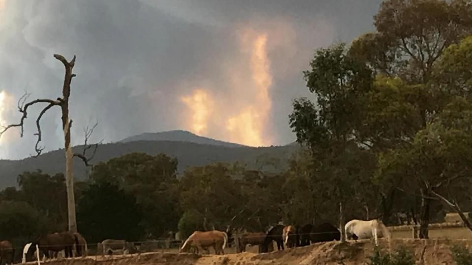
Hale Baron shared video of the large smoke plumes emanating from the fire, describing the “roaring” and “unrelenting” high wind that was presenting challenges to firefighting efforts.
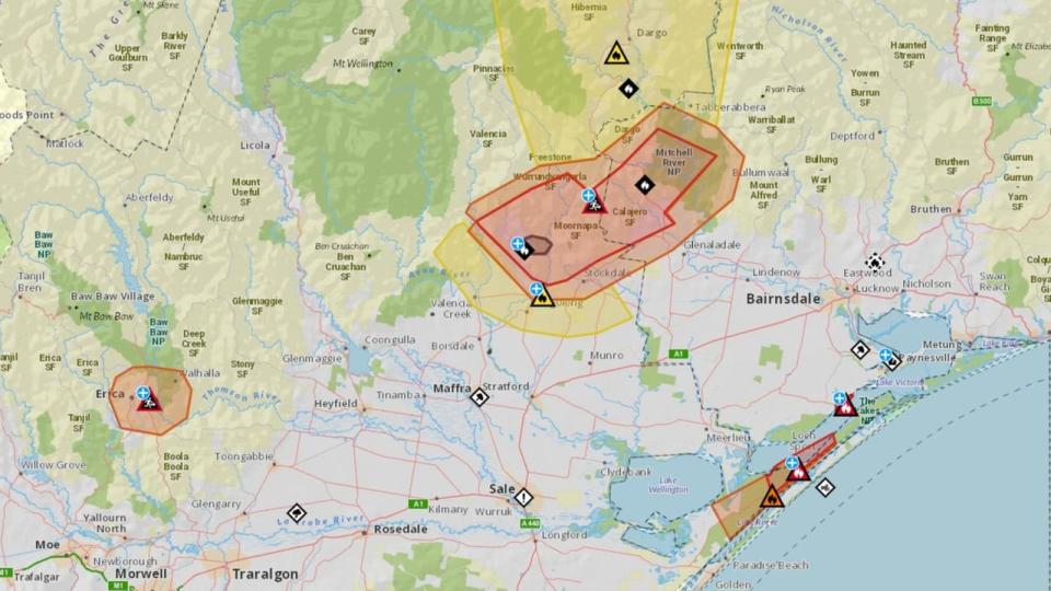
Gippsland South MP Danny O’Brien said the “horrendous wind” was causing serious fire concerns through the region, with blazes also underway in the Loch Sport and Forge Creek areas.
“If you don’t need to be there, best to stay off the roads in these areas today and please keep informed of the action you should take via the Vic Emergency app,” Mr O’Brien told residents.
Nearby, residents at Merrijig, Iguana Creek, Stockdale, Cobbannah and surrounds were being told to prepare to leave, while areas to the north and south of Briagolong were under an Advice warning.
Further south, an out of control grass fire at Loch Sport had triggered a serious emergency warning, with residents there being ordered to shelter indoors, with a second grass fire at Forge Creek.
On social media, residents there described being evacuated to the Loch Sport boat ramp carpark, with others offering similar descriptions of high wind which worsened already bad fire conditions.
Residents at Rawson, Walhalla, and Erica, east of Melbourne, as a bushfire travelling Knotts Siding Rd in a south-westerly direction had yet to be brought under control by firefighters.

Millions of families are being warned to be on alert after an extreme fire warning was issued for large swathes of NSW, including the Greater Sydney Region, with temperatures forecast to soar.
The warning will be in place for the rest of Sunday over much of the state’s coastline, including the Greater Hunter and Far South Coast, as well as North Western and Upper Central West Plains.

Just before 1pm on Sunday, there were 20 active alerts for bushfires in Victoria and 42 alerts in NSW – not including grass fires.
The Bureau of Meteorology warned a south-westerly change with move across southern areas of the state during the day on Sunday, bringing with it a strong and gusty wind along the south coast.
Families travelling over the holiday weekend were warned earlier to brace for “risky” bushfire conditions after a snap ban was put in place in some of NSW’s most sought-after tourist destinations.
Australia’s eastern states are forecast to swelter through the holiday weekend with temperatures forecast to reach 36C, triggering a ban on solid fuel fires in national parks on the NSW south coast.
NPWS South Coast director Kane Weeks said campfires and solid fuel fires were “too risky” under the current conditions, with travellers instead limited to gas, liquid fuel or electric stoves.
“Right along the coastal and escarpment reserves, dry conditions combined with hot, dry weather means that campfires are a risk in bushland areas throughout the region,” Mr Weeks said.


“Bushfires can start very easily from the sparks of a campfire … All it takes is a gust of wind and we could have a bushfire. There are many examples where campfires caused major bushfires.”
Total fire bans were already in place on Sunday across the state, including on the Far South Coast, Great Sydney, Monaro Alpine, Northern Slopes, and Central Ranges NSW RFS fire districts.
Fire permits were already suspended in many of the affected regions, including the lower Hunter area where firefighters had already been battling blazes “day and night” over past weeks.
“The past two weeks – as we head towards the official start of the fire season – has seen us and our partner agencies fighting fires day and night, with the support of aircraft,” the local RFS said.
“Due to the current predicted temperatures and conditions going into the week – in conjunction to the fire activity in the area over the past week – a decision has been made to suspend fire permits.”
The sizzling weather will begin to settle into the east from Friday, as a mass of hot air from Western Australia makes its way south where it will remain until at least Wednesday.
“Over the coming days heat really settles into parts of the southeast,” Sky News meteorologist Bradlyn Oakes said.
“Part of this is helped by the upper atmosphere pattern; we’ve got a lot of hot air pulling in and you can see it out there.
“That stretches from the northwest down toward the southeast, keeping things very warm for the next few days ahead.”
Rugby league lovers were warned that this year’s NRL grand final could be the hottest on record off the back off an earlier heatwave in September.

The Broncos-Panthers dust-up was booked for 7.30pm at Accor Stadium, with temperature to hover around 30C at kick-off.
NRL head of football Graham Annesley said the league was “ready for any circumstances” as organisers faced down Sunday’s brutal heat.
If any Greater Sydney weather station exceeds 37.3C in the first three days of October, it will be the highest early spring temperature on record.
The Bureau of Meteorology forecasts temperatures to reach a maximum of 36C on Sunday in the city, up 8C from the day before.
While conditions are expected to ease on Monday, the mercury is expected to rise again into next week with highs of 37C on Tuesday.
Though the grand final will be a scorcher, Tuesday’s temperatures are truly concerning, according to Ms Oakes.

“There are many areas of NSW as well as down through the ACT and Victoria that are likely to be 8, 10, 12, 14 degrees above average,” she said.
After a steamy Grand Final day on Saturday, Melbourne will enjoy cooler temperatures on Sunday, with a maximum of 21C forecast, before the heat hits one final time on Monday. Into the week, the temperature will dip as up to 15mm of rain moves in.
In the nation’s capital, temperatures are forecast to reach a whopping 31C on Tuesday compared with 19C recorded on the same day last year.
Brisbane is also expected to reach as high as 27C over the weekend, while Hobart will reach 23C on Saturday – 10C above the same day last year.
Fire warning
The Northern Territory is also staring down a blast of heat and fire danger warnings.
The bureau issued fire warnings for the Darwin and Adelaide River, Gregory South East and Barkly North districts on Thursday.
“Warm and dry with moderate to fresh and gusty northeast to south-easterly winds across most parts of the Territory,” the bureau said.
“Winds combined with high fuel loads will result in elevated fire dangers in the Barkly North, Darwin and Adelaide River and Gregory South East fire weather district.”
Catastrophic fire danger is forecast for Barkly North, while extreme fire danger is forecast for the Darwin and Adelaide River and Gregory South East.
NT Fire and Rescue Service has advised residents to immediately action their bushfire survival plans.
Temperatures are forecast to hover around 34C and 35Cs through to Monday.
The national breakdown
Other parts of the country will also face steadily warming temperatures.
The bureau forecasts a max temperature of 31C to hit Adelaide on Monday, while Brisbane will experience temperatures in the high 20s into the week.
Perth will enjoy a cooler weekend, with max temperatures forecast to reach 21C on Sunday before dropping to a top of 18C on Sunday.

