
UK weather: Met Office issues two amber warnings for snow covering Wales and Peak District
Two amber weather warnings for snow have been issued by the Met Office.
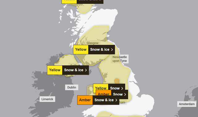
Both come into effect on Thursday, with the first covering north Wales and northwest Shropshire, and the other the Peak District and south Pennines.
The warning in Wales lasts from 8am until 3pm, while the one for the Peak District starts at 12pm on Thursday and continues until 6pm.
The Met Office has said 1-2cm of snowfall is possible in low-lying areas, while 10-20cm is possible over the highest ground within the warning areas.
Check the weather forecast in your area
The amber warning for Wales and northwest Shropshire says snow and ice are "expected to cause disruption".
The Met Office says there is a "good chance that some rural communities could be temporarily cut off".
People are also warned that travel delays are likely on roads, with the possibility of some vehicles and passengers becoming stranded.
Disruption to rail services is also possible, with the potential for power cuts and mobile phone coverage dropping out.
An amber warning is the second most serious alert issued by the Met Office - with yellow being the least serious and red being the most.
The amber warning for the Peak District and the south Pennines states that travel disruption can be expected.
Rural communities could be cut off, delays to rail services are likely and power cuts are possible.
In another new warning issued on Wednesday, much of the south of England will be covered by a yellow rain warning between 2am on Thursday and 6am on Friday - with people warned "periods of heavy rain" could cause the flooding of homes and businesses.
Warnings across the UK
A yellow warning for snow is also in place for a large part of England and northern Wales on Thursday.
It covers the Midlands and parts of northern England including Leeds, York and Carlisle, and is in place between 6am on Thursday and 6am on Friday.
The warning says a period of snowfall could bring disruption and some rural communities might be cut off.
Travel delays and power cuts are also possible.
There is also a yellow snow and ice warning in force for most of Northern Ireland between 10am on Thursday and 6am on Friday.
Another yellow snow and ice warning is in place across much of southern Scotland from 6pm on Thursday to 3pm on Friday.
The warning also covers part of central Scotland.
And a yellow weather warning will also be in place in central and northern Scotland from 3pm on Friday to 6pm on Saturday.
Read more:
Sleepy polar bear image wins top prize
Mr Bean actor blamed for slow electric car sales
King has meeting with Prince Harry after cancer diagnosis
Snow risk greatest from Thursday
Met Office deputy chief meteorologist, Chris Almond, said: "There's an increased signal for wintry hazards as we move through the week as cold air from the North moves over the UK.
"It's from Thursday that the snow risk becomes potentially impactful, as mild air attempts to move back in from the South, bumping into the cold air and increasing the chance of snow where the two systems meet.
"While there are still lots of details to work out, the initial snow risk looks highest in northern England and Wales from Thursday."
The alerts for Thursday, Friday and Saturday come as yellow warnings are in place for northern Scotland today.
One of them is in place until midnight, while the other will be in place from 4pm today until 10am on Thursday.
Snow and ice are expected to bring difficult driving conditions and potential disruption to rail networks.

