
UK weather latest updates: Storm Agnes forecast to bring heavy rain and winds up to 80mph
Strong winds and heavy rain are set to batter the UK as Agnes, the first named storm of the season, sweeps across the country this week.
The Met Office has issued a danger to life warning for Wednesday and Thursday, covering large swathes of the country. Gale force winds could result in travel disruption, damage to buildings and even power cuts, the forecaster has warned.
Met Office chief meteorologist Steve Ramsdale said: “While the precise track and depth of Storm Agnes is still being determined, there’s a high likelihood of wind gusts around 50 to 60mph for some inland areas. Exposed coastal areas could see gusts of 65-75mph with a small chance of a few places seeing around 80mph.”
He added that around 60mm of rain would be possible in a few areas of high ground in Scotland.
Storm Agnes follows a week of heavy downpours in parts of the UK. Britain was hit by the remnants of two hurricanes, Lee and Nigel, dumping large amounts of rain that led to flooding in London and other parts of the country.
Flood alerts issued in England and Scotland
10:08 , Athena Stavrou
The Met Office has issued flood alerts for areas across England and Scotland.
In England, three flood alerts have been issued for two areas in the Lake District and also for areas surrounding the River Thame in Oxfordshire.
In Scotland, the Scottish Environment Protection Agency (SEPA), have issued a flood alert for the Western Isles and warn residents to “remain vigilant”.
What the weather will be like near you during Storm Agnes
09:03 , Athena Stavrou
With Storm Agnes set to hit the UK later this week, here is what the weather will look like near you from Wednesday to Friday, according to the Met Office.
London and the South East
Dry start Wednesday, before wet and windy weather sweeps quickly northeastwards overnight, risk of gales. Sunshine and scattered showers Thursday and Friday. Windy. Temperatures around average by day. Mild nights.
The south west
Heavy rain clearing to sunnier skies on Wednesday, though likely very windy. Less windy, with further rain or showers on Thursday and Friday. Temperatures closer to average.
The Midlands
After a fine start, turning wet and very windy on Wednesday. Less windy, with further rain or showers on Thursday and Friday. Temperatures closer to average.
The north east
Dry and bright start Wednesday, before wet and windy weather quickly sweeps northeastwards later, with gales likely, clearing overnight. Sunshine and showers following Thursday and Friday. Windy and staying mild.
The north west
Persistent heavy rain developing on Wednesday, with severe gales possible. Further rain or showers from the west on Thursday and Friday and remaining breezy. Temperatures closer to average.
Scotland
Windy conditions continuing later in the week. Dry and bright on Wednesday and Thursday but some heavy overnight rain likely. Sunny on Friday but a few blustery showers.
Wales
More persistent rain on Wednesday, and turning very windy with severe gales. Less windy, with further rain or showers on Thursday and Friday. Temperatures closer to average.
UK airports brace for weather disruption
08:07 , Athena Stavrou
Birmingham Airport has issued advice to travellers ahead of today’s storm.
A spokesperson for the airport told BirminghamLive: “We are prepared for these weather conditions and will be operating in line with our usual extreme weather procedures.”

What is Storm Agnes?
07:30 , Martha Mchardy
Storm Agnes is a deep area of low pressure developing in the Atlantic.
According to forecasters, it is likely to move in from the southwest on Wednesday and move up through the Irish Sea to northern areas of the UK throughout the day.
Full list of Met Office’s storm names for 2023/2024
07:00 , Martha Mchardy
The Met Office has released 21 storm names for the upcoming autumn and winter period.
Agnes
Babet
Ciaran
Debi
Elin
Fergus
Gerrit
Henk
Isha
Jocelyn
Kathleen
Lilian
Minnie
Nicholas
Olga
Piet
Regina
Stuart
Tamiko
Vincent
Walid
Dry weather forecast after Storm Agnes
06:30 , Stuti Mishra
After Storm Agnes brings two days of heavy rain showers and strong winds beginning tomorrow, the Met Office forecasts the weather will turn mostly dry on Friday and remain so on Saturday.
While there are no signs that a hot spell is on the cards, the forecaster says showers will begin to ease from Thursday afternoon giving way to pleasant conditions.
Afterwards, a changeable pattern is expected through this period, with "a fairly settled start [to October] across most parts of the UK, excluding northern areas, where showers are likely to continue, especially in the northwest."
23C temperature recorded on Monday
06:00 , Stuti Mishra
The Met Office says Monday remained a warm day for most in the UK with temperatures around 3-5°C above the late-September average.
While the north saw temperatures in the teens, the south basked in sunshine for most parts with temperatures ranging from 20-23C.
From Tuesday onwards, as wind and rain arrives with Storm Agnes, the temperatures are set to plummet but may stay close to the average for most parts.
UK weather forecast for today
05:30 , Stuti Mishra
The Met Office is predicting showers and longer spells of rain today ahead of Storm Agnes' arrival.
While the worst weather is expected to begin from Wednesday when there is a yellow warning in place, today can be wet and windy for many, especially in the north.
However, the south could see skies clearing for a mostly dry day during the afternoon with light winds.
Storm Agnes expected to diminish on Thursday, says Met office
05:00 , Martha Mchardy
Storm Agnes’s influence on UK weather is expected to diminish later on Thursday as it weakens and moves further north, the Met Office said.
Rain will then move into southern areas late on Thursday and into Friday, with some heavy bursts possible for some areas of England and Wales.
But as we head into the weekend, a ridge of high pressure from the south is expected to bring a period of more settled weather, though some showers could continue in northern and western areas for a time.
Which regions will Storm Agnes affect?
04:30 , Stuti Mishra
The storm will affect western regions of the UK and Ireland on Wednesday, with the most powerful winds expected on the Irish Sea coasts.Scotland, Wales, Northern Ireland and northern England will also see heavy rainfall, with the possibility of up to 60mm in high-altitude areas of Scotland.
“As well as some very strong winds for many, Storm Agnes will also bring some heavy rain, with the highest totals more likely in Scotland, northern England, Wales and Northern Ireland. Around 60mm of rain is possible in a few places over high ground in Scotland.”
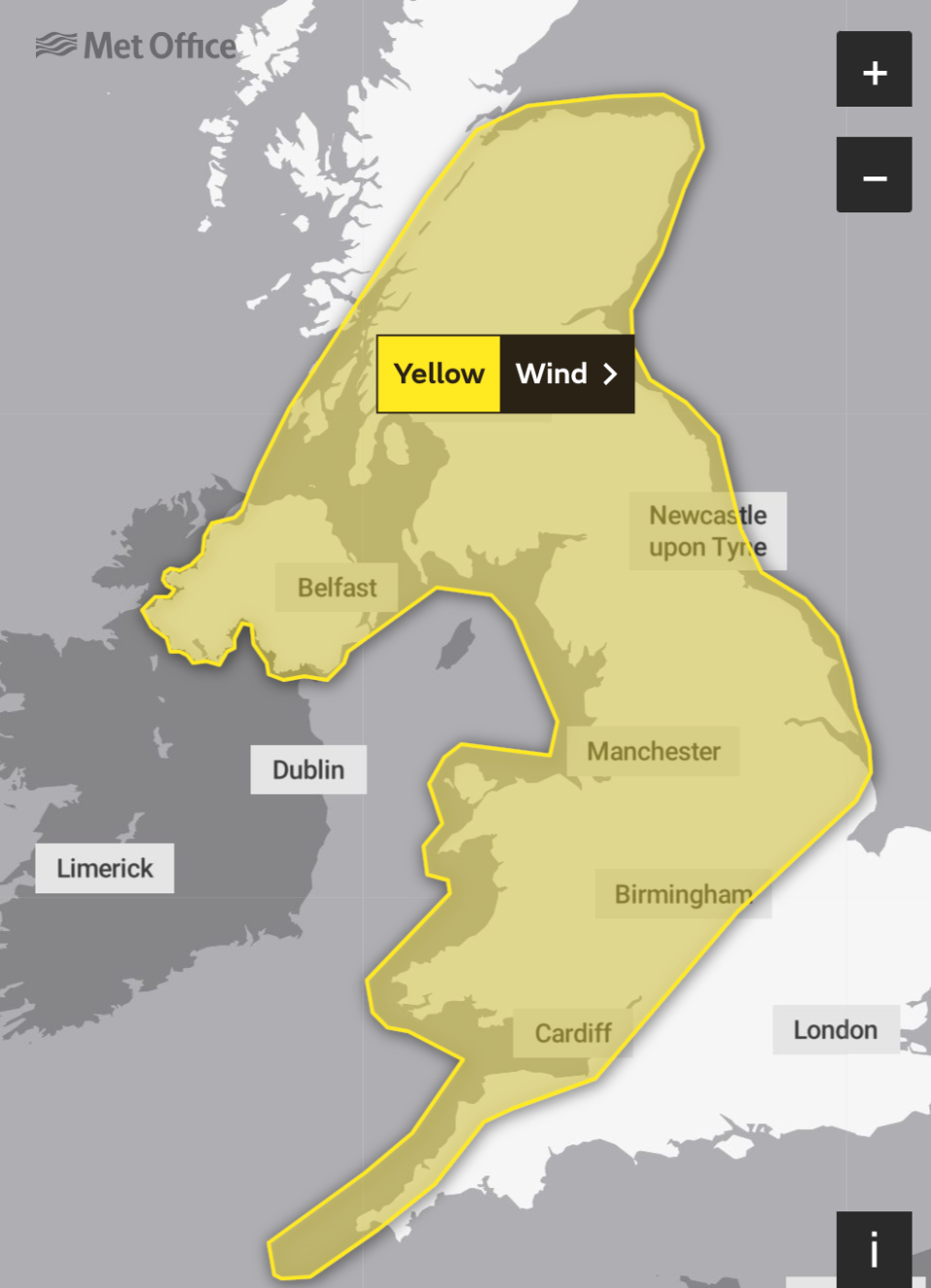
A yellow warning for wind has been issued for a large area of the UK, with a rain warning also issued for parts of Scotland.
Met Office yellow weather warnings map
04:00 , Martha Mchardy

Highs of 24C forecast after Storm Agnes
03:00 , Martha Mchardy
An Indian Summer with highs of 24C is set to hit the UK after Storm Agnes.
Warm temperatures are set to hit parts of the UK on Saturday until the following Tuesday, according to experts.
British Weather Services’ senior meteorological consultant Jim Dale told the Mirror: “A taste of an Indian summer is currently on the cards in the aftermath of the ‘offspring’ of the ex-hurricane Nigel [Storm Agnes], and will last from Saturday to the following Tuesday. It’ll mainly cover South-East England, with 23 or 24C possible at the upper limits.
“Prior to that warmth, the Atlantic storm is forming and will move in from the Southwest, crossing northern parts of the UK on Wednesday. I first saw this potential development last week, and warned it may turn into a potent force.
“Expect 60 to 70mph gusts in the North-West, and 40 to 50mph gusts elsewhere. There will be sizeable rain too, mainly in the same areas as the highest winds, with more than 25mm expected in places. As ever we watch and wait!”
The 13 UK regions expected to be hit by Storm Agnes
02:00 , Martha Mchardy
The Met Office has given 13 UK regions an official weather warning as Storm Anges approaches on Wednesday.
The 13 regions are listed below:
Central, Tayside & Fife
East Midlands
Grampian
Highlands & Eilean Siar
North East England
North West England
Northern Ireland
SW Scotland, Lothian Borders
South West England
Strathclyde
Wales
West Midlands
Yorkshire & Humber
ICYMI: Lightning struck 9,000 times during ‘insane’ thunderstorm
01:00 , Martha Mchardy
Torrential downpours during an ‘insane’ thunderstorm led to flash flooding as roads in parts of the UK turned into rivers.
Dramatic footage taken in Kenton, Devon, showed rainwater streaming down roads and into a village square as residents waded through in boots.
And in Dawlish, Devon, a bridge crossing over a river was totally submerged after the huge downpour struck the southwest of England on Sunday.
Alexander Butler reports:

Lightning strikes 9,000 times during ‘insane’ thunderstorm as UK hit by flash floods
ICYMI: London roads turn into rivers after ‘monsoon’ rain with more coming from Hurricane Nigel
Tuesday 26 September 2023 00:00 , Martha Mchardy
Torrential rain across London left streets flooded with firefighters working tirelessly throughout Wednesday evening to respond to calls.
With heavy rain only set to get worse ahead of Hurricane Nigel, the Met Office has warned of potential flooding and the possibility of interruption to power supplies.
The London Fire Brigade received “numerous calls” over flooding as dramatic footage showed roads turning into rivers, with crews “working as quickly and as safely as they can” to provide assistance.
Holly Evans reports:

London roads turn into rivers after ‘monsoon’ rain ahead of Hurricane Nigel
Met Office 4 day weather forecast
Monday 25 September 2023 23:00 , Martha Mchardy
Monday:
Early cloud soon clearing from southeast England, then mostly dry with sunny spells and lighter winds across southern and central areas. However, windy with scattered showers further north, some heavy.
Tuesday-Thursday:
Sunshine and showers on Tuesday, the showers heavy and blustery in places. Wednesday could see some disruption due to heavy rain and very strong winds. Gradually improving on Thursday.
Danger to life warnings issued by Met Office as 80mph winds set to batter Britons
Monday 25 September 2023 22:00 , Martha Mchardy
The Met Office has issued danger-to-life weather warnings as 80mph winds are set to batter the UK.
A yellow warning has been put in place across the majority of the UK from 10am on Wednesday until 7am on Thursday, spanning from the southwest of England, across to Northern Ireland and up to Inverness.
Gale force winds across swathes of the country could result in travel disruption, damage to buildings and even power cuts.
Eleanor Noyce reports:

Danger to life warnings issued by Met Office as 80mph winds set to batter Britons
Latest pictures as Storm Agnes set to hit UK
Monday 25 September 2023 21:00 , Martha Mchardy

AA issues warning to drivers ahead of Storm Agnes
Monday 25 September 2023 20:00 , Martha Mchardy
Drivers have been issued advice ahead of Storm Agnes.
The AA warned drivers to stay safe this week as Storm Agnes brings winds of up to 80mph.
Nick Powell, AA patrol of the year, said: “Many places across the UK are likely to see strong winds this week and it’s very likely trees and debris will be littering the roads. Drivers should be very cautious, especially in rural or woody areas.
“If you see twigs or small branches on the road it could be a sign that a tree has fallen just around the bend, so pay extra attention to the path up ahead.
“As always in windy weather, leave plenty of space behind other vehicles and adjust your speed to suit the conditions, especially when crossing bridges or passing high-sided vehicles. Those on two wheels are especially vulnerable to strong winds, so you should pass these with care.”
“Make sure you bring essentials with you on your journey, even if it is only short, such as warm layers, food and drink and a fully charged mobile phone. Downloading the free what3words app will allow users to accurately report the location of fallen trees or other items blocking the road.”
Storm Agnes to bring ‘disruptive winds’ to UK, says Met Office
Monday 25 September 2023 19:00 , Martha Mchardy
Storm Agnes will bring “disruptive winds” to the UK, the Met Office has said.
In a tweet, the Met Office said: “A powerful jet stream will send #StormAgnes across the Atlantic Ocean towards the UK As #Agnes crosses onto the northern side of the jet stream, it will rapidly deepen and bring some disruptive winds to parts of the UK.”
A powerful jet stream will send #StormAgnes across the Atlantic Ocean towards the UK
As #Agnes crosses onto the northern side of the jet stream, it will rapidly deepen and bring some disruptive winds to parts of the UK
⚠️ Stay #WeatherAware pic.twitter.com/osLqduz1v0— Met Office (@metoffice) September 25, 2023
How did Agnes get her name?
Monday 25 September 2023 18:00 , Martha Mchardy
Storm Agnes is the first named storm of the storm naming season, which runs from September to August the following year.
In the UK, a decision to name a storm is based on strength of winds and the resulting impacts. The decision is made by the chief meteorologist at the Met Office in collaboration with other weather organisations in northern Europe.
The Met Office, in partnership with Met Éireann (Irish Met Office) and The Royal Netherlands Meteorological Institute (KNMI), announced a new list of storm names for this years storm naming season. The Met Office say that naming storms helps to communicate the risks of severe weather.
It was decided that Agnes, Babet and Ciarán will be the first three named storms.

Predicted path of Storm Agnes
Monday 25 September 2023 17:00 , Athena Stavrou
As Storm Agnes makes it’s way across the Atlantic Ocean to the UK, the map below shows it’s predicted path.
Storm Tracking - #stormAgnes
[UPDATE 1] Storm Agnes is expected to impact UK and Ireland through Wednesday, bringing locally large rainfall totals and disruptive, possibly damaging, winds. The system is currently developing and should peak in intensity shortly before landfall. pic.twitter.com/wy4JqLRdhR— UK Weather Updates (@UKWX_) September 25, 2023
When will Agnes subside?
Monday 25 September 2023 16:00 , Athena Stavrou
Storm Agnes’s influence on UK weather is expected to diminish later on Thursday as it weakens and moves further north.
The Met Office say that following that system, rain will move into southern areas late on Thursday and into Friday, with some heavy bursts possible for some areas of England and Wales.
However, Britons can expect a period of “more settled weather” by the weekend, though some showers could continue in northern and western areas for “a time”, according to the forecasters.
Limited time for recovery as UK faces storm Agnes a week after Hurricane Nigel and Lee wrecked havoc
Monday 25 September 2023 15:30 , Athena Stavrou
Britons will have little time to recover from last week’s bad weather, as Storm Agnes is set to cause delays and power cuts less a week after Hurricane Nigel and Lee turned roads into rivers.
Last week, torrential rain across London left streets flooded with firefighters working tirelessly throughout Wednesday evening to respond to calls.
One social media user joked she “wasn’t sure whether to run or swim” around the streets of London, while another compared it to “monsoon weather” in Croydon.
Now the UK is preparing to deal with yet another spell of extreme weather just one week later, as storm Agnes is due to arrive on Wednesday.
Take a look at how the UK dealt with last week’s weather:
London roads turn into rivers after ‘monsoon’ rain ahead of Hurricane Nigel
80mph winds predicted this week
Monday 25 September 2023 15:00 , Athena Stavrou
The Met Office has said that some parts of the UK could see wind speeds of up to 80mph later this week.
They said that there’s a “high likelihood” that wind gusts could reach 50 to 60mph for some inland areas while exposed coastal areas could see speeds of 65-75 mph.
Met Office Chief Meteorologist Steve Ramsdale said there was a “small chance” some places would see speeds of 80 mph.

Flooding “likely” in some parts of the UK later this week
Monday 25 September 2023 14:30 , Athena Stavrou
The Met Office has issued yellow rain warnings for some areas of the UK and warns flooding is “likely”.
The warning was issued for areas across Scotland including the Strathclyde, Grampian, Lothian Borders and Tayside & Fife regions for Wednesday and Thursday.
According to the forecaster, flooding of a few homes and businesses is “likely” and some bus and train services would “probably” be affected.
Monday 25 September 2023 14:00 , Athena Stavrou
Satellite map shows storm Agnes’ projected path
A satellite map has shown the predicted path for Storm Agnes as it makes it’s way across the north Atlantic.
The maps show both the projected wind and rain forecasts for the coming days.
#StormAgnes has been named by the UK Met Office.
A deep area of low pressure is developing in the North Atlantic, enhanced by the remnants of Hurricane Ophelia. This low will bring strong winds and heavy rain to the UK and Ireland on Wednesday.
Wind forecast | Rain forecast: pic.twitter.com/91PIR5SEvL— Zoom Earth (@zoom_earth) September 25, 2023
Areas across the UK issued yellow weather warning
Monday 25 September 2023 13:20 , Athena Stavrou
The Met Office have issued yellow weather warnings for large areas across the UK.
The map shows the areas affected by the wind warning, which could see a “small chance of injuries and danger to life”, according to the forecaster.
Met Office issue danger to life warning
Monday 25 September 2023 12:40 , Athena Stavrou
The Met Office have issued a danger to life warning for Wednesday and Thursday as strong winds sweep across the country.
A yellow warning for winf has been issued for a large area of the UK, with the Met Office warning that there is a “small chance of injuries and danger to life from flying debris”.
They also added that danger to life could occur from large waves and beach material being thrown onto sea fronts, coastal roads and properties.
Power cuts, cancellations of rail services and closure of some roads and bridges are also possible.
⚠️ Yellow weather warning UPDATED ⚠️#StormAgnes is expected to bring strong winds across a large part of the UK
Wednesday 1200 – Thursday 0700
Latest info 👉 https://t.co/QwDLMfRBfs
Stay #WeatherAware⚠️ pic.twitter.com/PBSBxUe8Td— Met Office (@metoffice) September 25, 2023
Storm Agnes set to batter the UK with strong winds and heavy rain across the country
Monday 25 September 2023 12:06 , Athena Stavrou
The Met Office have warned that strong winds and heavy rain are set to batter the UK as Agnes, the first named storm of the season, sweeps across Britain on Wednesday and Thursday.
A danger to life warning has been issued by the Met Office for Wednesday and Thursday, as they warn of up to 80mph winds in some areas of the UK.
Storm Agnes follows a week of heavy downpours in parts of the UK. Britain was hit by the remnants of two hurricanes, Lee and Nigel, dumping large amounts of rain that led to flooding in London and other parts of the country.
The Met Office chief meteorologist Steve Ramsdale said: “While the precise track and depth of Storm Agnes is still being determined, there’s a high likelihood of wind gusts around 50 to 60mph for some inland areas. Exposed coastal areas could see gusts of 65-75mph with a small chance of a few places seeing around 80mph.
“As well as some very strong winds for many, Storm Agnes will also bring some heavy rain, with the highest totals more likely in Scotland, northern England, Wales and Northern Ireland. Around 60mm of rain is possible in a few places over high ground in Scotland.”

