
Town set for 150mm rain blast over 24 hours

A bitter cold snap has marked the end of the warmer months as part of the Northern Territory braces for 150mm of rain in 24 hours and multiple states set to shiver through below average temperatures over the weekend,
The mercury plummeted across the country’s state capitals on Thursday, reaching just 23C in the Harbour City.
Below average temperatures are forecast for most of the country this weekend, with southern Victoria and eastern parts of New South Wales all expecting cooler days.
Below average temperatures are forecast for much of the country over the coming days, before warming up from Monday for southern #Vic, eastern parts of #NSW and far south-west #WA.
More: https://t.co/jlOoTZL1iFpic.twitter.com/cyDhyVNtZv— Bureau of Meteorology, Australia (@BOM_au) March 21, 2024
Northern Territory
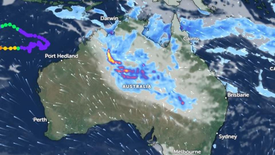
In the cyclone-hit town of Borroloola, more than 300 people have been evacuated on defence force aircraft as flash flooding hits the region.
Ex-Tropical Cyclone Megan tore through the Northern Territory earlier this week, bringing more than half a year’s worth of rain to the community of Groote Eylandt off the north coast.
Defence force flights scheduled to evacuate more than 700 residents from Borroloola before the cyclone hit were cancelled after wild weather made it too difficult to land.
Up to 80mm of rain is likely to fall within six hours on Friday, with 24-hourly rainfall totals of up to 150mm possible.
A record major flood peak along the McArthur River was expected to pass through Borroloola on Thursday evening.
NSW
The Bureau of Meteorology forecast a maximum temperature of 24C on Friday and windy conditions in northern parts of NSW.
Conditions will be mostly sunny over the weekend, though despite the blue skies the maximum temperature will likely stay below 26C on the weekend.
The warmer weather is not entirely over however, with a blast of heat predicted to hit Sydney on Monday with a high of 28C.
Victoria
Melbourne has a cooler weekend ahead with a high of 22C on Friday, and a 21C on Saturday.
Southerly winds of up to 25 km/h are possible in the early afternoon on both days.

Western Australia
The western state has managed to escape the worst of the chill, with a last push of heat bringing temperatures in Perth to a high of 30C this weekend.
Further north in Carnarvon, the mercury could even inch above 40C on Saturday.
Queensland
A Flood Watch warning is in place for parts of The Cape York Peninsula, Gulf Country and North Tropical coast in the wake of Ex-Tropical Cyclone Megan.
Multiple rivers and creeks are elevated following recent rainfall and forecasted heavy rainfall could lead to quick rises.
Localised heavy falls with thunderstorm activity and moderate widespread rainfall are forecast over the next few days.
Meanwhile in the south-east of the state, showers are forecast to linger in Brisbane until mid-next week.
South Australia
A sunny weekend is expected in Adelaide with strong wind gusts cooling down in the early afternoon.
A high of 25C is likely on Friday and Saturday, though southerly gusts of up to 40km/h will hit the capital in the early afternoon.
Tasmania
The southernmost state is due to experience a chilly weekend with temperatures reaching just 20C on Saturday.
ACT
A chance of fog in the early morning in the ACT with a low of 8C on Saturday morning and a high of just 23C.

