
New tornado outbreak threatens storm-ravaged central US on Monday, Tuesday


AccuWeather meteorologists continue to warn of a looming significant severe weather and tornado outbreak for portions of the Plains and Midwest spanning Monday and Tuesday.
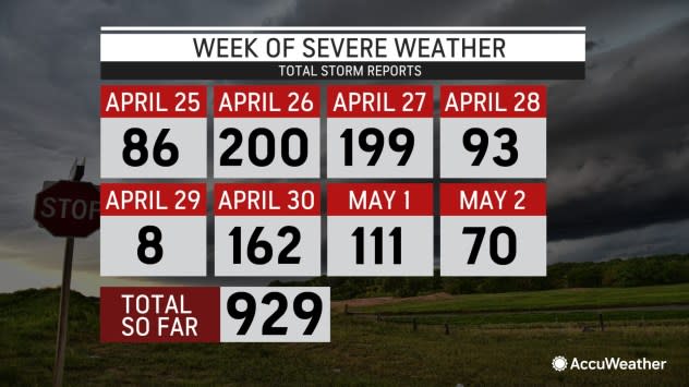
The relentless pattern that has produced over 1,000 incidents of severe weather and well over 100 confirmed tornadoes since April 25, mostly in the central United States, will continue well into next week.
 |
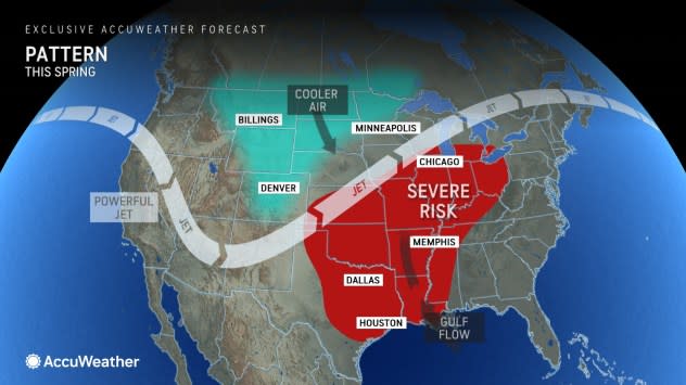
The trigger for the new rounds of severe weather and tornadoes is a potent storm that is pushing inland over the West this weekend. That storm will bring not only inches of rain and feet of mountain snow to Oregon and Northern California but also high winds over much of the West this weekend and the High Plains by Monday.
"As the energy from the Pacific storm extends east of the Rockies and comes in contact with a new surge of warmth and moisture from the Gulf of Mexico, an explosion of thunderstorms will take place over a large part of the Great Plains on Monday," AccuWeather Chief On-Air Meteorologist Bernie Rayno said.
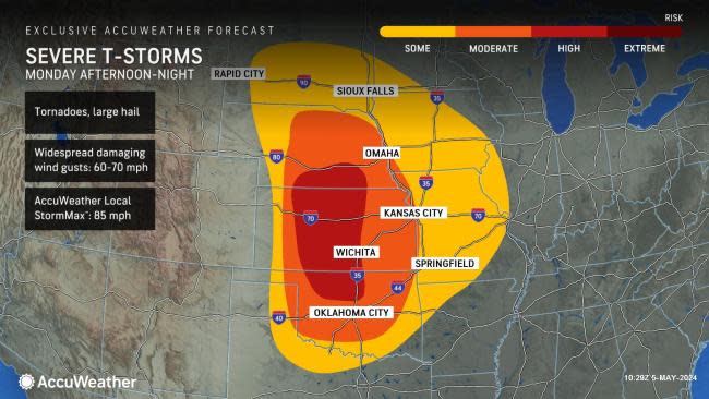
On Monday, the likelihood of severe weather extends from South Dakota to north-central Texas and reaches as far to the east as west-central Illinois. Within this area, AccuWeather has designated a moderate threat zone that includes much of central and eastern Nebraska and Kansas, central Oklahoma, northwestern Missouri and western Iowa.
 |
A high risk zone has been added by AccuWeather meteorologists that includes south-central Nebraska, central Kansas, and north-central Oklahoma.
The cities of Omaha and Grand Island, Nebraska; Kansas City and Springfield, Missouri; Des Moines, Iowa; Topeka and Wichita, Kansas; Oklahoma City and Tulsa, Oklahoma; and Sioux Falls, South Dakota; are at risk of severe thunderstorms and tornadoes on Monday afternoon and night.
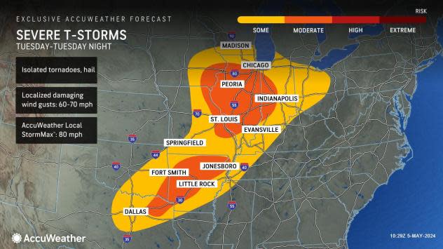
The likelihood of severe thunderstorms, some spawning tornadoes, will continue farther to the east over a large part of the Mississippi and Ohio Valleys on Tuesday.
On Tuesday, the severe thunderstorm and tornado risk will shift eastward a few hundred miles and extend to include the major cities of Chicago; Milwaukee; Indianapolis; St. Louis; Paducah, Kentucky; Memphis, Tennessee; and Little Rock, Arkansas.
 |
"We are probably looking at dozens of tornadoes being produced during the severe weather outbreak from Monday to Tuesday," Rayno said, "That number could range from a dozen to multiple dozens of tornadoes spanning the two days."
Along with the likelihood of tornadoes will be big thunderstorms that pack large hail and produce powerful straight-line wind gusts and flash flooding. Where tornadoes and large hail tend to affect only a tiny fraction of a severe weather watch and warning area, damaging winds can affect a much broader zone.
The situation will become dangerous and could be made worse by severe weather fatigue as the pattern this spring and especially in the past week or so has been relentless, AccuWeather Senior Vice President and Chief Meteorologist Jon Porter warned.
 |
"I hope people don't let severe weather alerts and warning fatigue set in, where they turn off audible alerts and notifications to get a break," Porter stated, "That could be very dangerous as they can miss out on life-saving information."
When radar indicates that a tornado is forming or when a tornado has been confirmed by spotters, every second counts to allow people to seek adequate shelter -- which is the purpose of tornado warnings. A tornado watch means to take note that conditions are threatening. A tornado warning means to take action and seek shelter immediately.
"There will be additional rounds of severe weather, and some may produce tornadoes beyond Tuesday," Porter said.
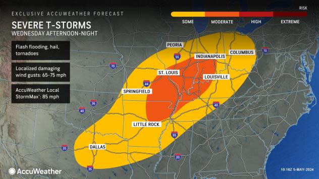
On Wednesday, AccuWeather has outlined a zone for severe weather from Illinois, Indiana and Ohio to northern Louisiana and northeastern and north-central Texas.
 |
"As a strengthening cold front presses eastward and southward late in the week, the risk of severe weather will extend from the Midwest to the Atlantic and Gulf coasts," AccuWeather Senior Meteorologist Matt Benz said.
Benz noted that during a pattern change, such as a strong cold front or dip in the jet stream, severe weather is often pushed into these areas.
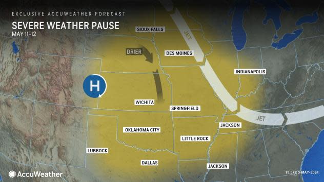
The same pattern change will mark a much-needed break from damaging storms and tornadoes over a large part of the Plains and Midwest starting late this week and continuing through the weekend.
 |
There may be an extended period without widespread areas of severe weather or at least storms packing violent tornadoes.
Want next-level safety, ad-free? Unlock advanced, hyperlocal severe weather alerts when you subscribe to Premium+ on the AccuWeather app. AccuWeather Alerts™ are prompted by our expert meteorologists who monitor and analyze dangerous weather risks 24/7 to keep you and your family safer.
