Thunderstorms may spark fires ahead of major cooldown for western US
Soon after another surge of heat cycles over the interior West this week, a series of changes will occur that will bring in cooler air and some showers to the Northwest, but it will not be before an uptick in dry thunderstorms that could spark wildfires over the interior Southwest, AccuWeather meteorologists warn.
A storm that has been hovering off the coast of California for over a week and helping to pump up the heat in the West will finally shift inland through Friday.
 |
Even though this storm will weaken and have very little moisture, an uptick in thunderstorms will occur as it moves over heated areas of the Southwest.
Because of limited moisture, many thunderstorms will produce little to no rainfall. However, because thunderstorms produce lightning, lightning strikes can spark multiple wildfires where they occur over dried grassland and brush. Hot and breezy conditions ahead of and during the storms can cause any fire that starts to spread quickly.
 |
This first storm will begin the change to lower temperatures, but a more pronounced setup will follow.
The first of two storms from the northern Pacific will roll ashore in the Northwest at the end of the week. That storm will be accompanied by a dip in the jet stream with cooler air. However, instead of the jet stream lifting northward in its wake, it will remain in place as another storm approaches for early next week.
The pattern will lead to rounds of clouds and showers with spotty thunderstorms from the Northwest to the northern Rockies.
The end result will be a large swath of Pacific air that will replace hot air that has formed in place over the western United States or percolated northward from Mexico.
 |
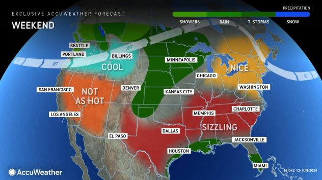
Astronomical summer begins at 1:50 p.m. PDT on Thursday, June 20. The final weekend before the changing of the seasons will likely be on the cool side, as air from over the Pacific will produce temperatures near or slightly below the seasonal average for much of the West.
For example, in Las Vegas, temperatures around 110 F into Saturday will be swapped with highs near 100 by early next week. More significantly, highs near 100 around Salt Lake City through Thursday will be swapped with highs in the low to middle 80s later this weekend to next week.
Farther north in Boise, Idaho, highs will trend into the upper 60s early next week. Temperatures in Sacramento, California, will stabilize with highs within a few degrees of 90 as soon as midweek. Following a high in the 100s midweek, temperatures will trend downward through the 90s in Fresno, California, later this week.
 |
As temperatures trend down with the jet stream dip in the West this weekend to next week, temperatures will surge in the East, where millions of people await the first heat wave of the year.
Want next-level safety, ad-free? Unlock advanced, hyperlocal severe weather alerts when you subscribe to Premium+ on the AccuWeather app. AccuWeather Alerts™ are prompted by our expert meteorologists who monitor and analyze dangerous weather risks 24/7 to keep you and your family safer.


