
50k without power as city hit by cyclone

Tropical Cyclone Kirrily crossed the coast near one of Queensland’s biggest cities overnight bringing 100km/h plus winds and damage to buildings.
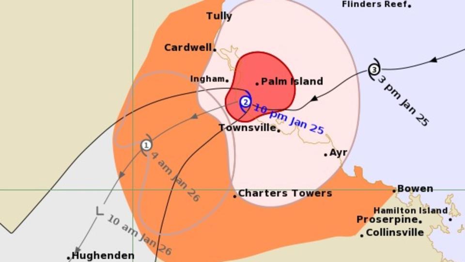
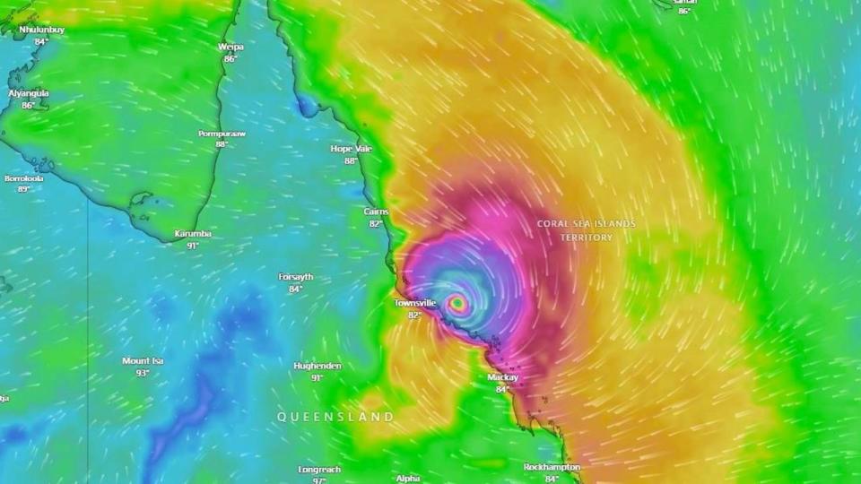
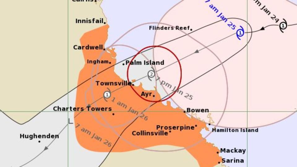
The storm crossed between Townsville and Ingham at around 10pm. As predicted, it has now weakened and is currently a category 1 cyclone situated north of Charters Towers and heading towards Hughenden.
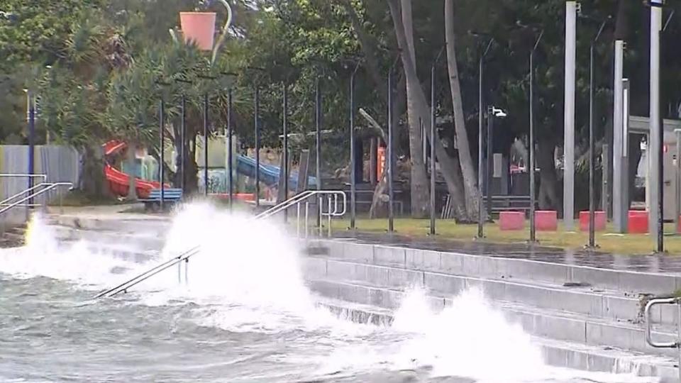
There are reports of boats breaking their moorings and becoming stranded on Townsville’s waterfront. However, so far, the winds have been less ferocious and there hasn’t been as much rain as expected.
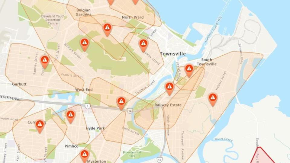
Nonetheless, a map of energy distributor Ergon’s website shows the chaos Kirrily has caused in Townsville, Queensland's third largest city with 180,000 residents.
The map shows around 50 separate areas of Townsville without power including much of the CBD.
Ergon Energy said about 55,000 people were without power.
“Our teams and their families in Kirrily’s path are bunkering down while this dangerous system roars in.” the organisation said in a Facebook post.
“The only priority tonight is safety – getting through this storm – then when it’s safe to start moving around tomorrow, we’ll begin damage assessments.”
Ergon Energy has said many homes are without power in Townsville and Burdekin with more outages reported in the Whitsunday, Hinchinbrook and Charters Towers shires.
Danger still persists
Residents around Townsville were told to brace for possibly 170km/h wind gusts due to a category 3 storm.
However, Kirrily reduced in intensity to a category 2 cyclone just before it reached land meaning winds were below that maximum- although still strong enough to cause damage.
At 7.42pm on Thursday at 93km/h gust was recorded in Townsville. Cape Ferguson, south of Townsville, recorded winds just shy of 100km/h at multiple times during the late evening. Mt Stuart got to 100 km/h at 7.30pm and Alva Beach peaked at 107km/h.
Surprised at just how little rain we're seeing with this storm. Have experienced some fairly strong gusts in the past few minutes however along with some explosive power flashes quite close to our location 🌀#CycloneKirrilypic.twitter.com/v0pyECNNRB
— Jason H (AU) 🇦🇺 (@OreboundImages) January 25, 2024
Back in #Townsville after following the system to the north and winds are still at gale force on the coast, perhaps even a little stronger than earlier 🌀#CycloneKirrilypic.twitter.com/dxIqV8tnmA
— Jason H (AU) 🇦🇺 (@OreboundImages) January 25, 2024
A cyclone warning zone is in effect from Cardwell to Ayr including Townsville and Charters Towers. There could be strong winds and heavy rainfall throughout the area including possible flash flooding.
As it progresses westwards, initially as a category 1 storm, winds near the centre of 85km/h with wind gusts to 120mh/h can be expected.
During Friday, the system is likely to track further inland as a tropical low, resulting in heavy to intense rain and possible damaging winds to parts of the northern interior and western Queensland, the BOM said.
A storm tide is also possible on Friday morning between Townsville and Alva Beach which could bring large waves and minor foreshore flooding including property damage.
Inland warning
A severe weather warning is in place for inland northern Queensland particularly the Goldfields and towns such as Hughenden and Richmond. Again it’s all about strong winds and heavy rainfall with possible flash flooding as s Kirrily passes over.
Moderate rainfall totals – the highest around 100mm at Clarke Range, inland from Mackay – were recorded on Thursday afternoon.
Sustained winds have also been “incredibly” high and would push onto inland areas later in the day, Bureau meteorologist Miriam Bradbury said.
She said the combination of wind and rain had the potential to bring down power lines, leading to possible road closures and power outages.
The resulting rain depression will be pushed into the central and western parts of Queensland over the following days, once the cyclone weakens.
The bureau has already warned that damaging gales are occurring over the Whitsunday Islands, while isolated falls of up to 300mm of rain could descend on other regions in the coming days.
In footage captured by 9 News, wild waves lash the foreshore at Bowen, north of Mackay, over Wednesday and Thursday as conditions continue to ramp up.

Those same winds are expected to extend northward to coastal and island communities between Ayr and Ingham.
They may extend up to Innisfail if the system takes a track further north, the bureau has warned.
On Thursday, Bureau meteorologist Angus Hines said some wind gusts along the Whitsundays region had already clocked 102km/h.
Others at Flinders Reef reached 94km/h.
Mr Hines said the winds would spread throughout the area, prompting a warning that power lines could be downed and trees could be uprooted.
“The strongest gusts are expected late Thursday and early Friday before that wind will start to fade away,” he explained.
Mr Hines said ocean water could also be pushed onto low-lying roads due to surging storm tides.
“That’s most likely between Townsville and Mackay at high tide,” he said.
For the next few days, widespread 100-200mm rainfall totals are expected from the coast to the Northern Territory border as the cyclone weakens into a tropical rain depression.
Isolated spots could cop up to 300mm of rain, Mr Hines said.
“That amount is certainly going to contribute to the possibility of riverine flooding,” he said.
“We still have a broad flood watch in place across northern Queensland covering almost all rivers in this part of the country.”
On Thursday, Mr Miles said authorities were “prepared and ready for the worst” and would now “wait and hope for the best”.

He explained the state had pre-emptively declared the weather event a disaster to seek assistance from the federal government.
“We’ve already received 146 calls for assistance from the SES … most of them asking for assistance with sandbagging,” Mr Miles said.
Townsville residents have already taken preparations, with businesses and hundreds of schools closed.
Pre-emptive disaster declarations would allow emergency services to have the appropriate powers to assist impacted communities, state disaster co-ordinator Deputy Commissioner Shane Chelepy said.
He reiterated the next few days would be “critical” for residents.
“Police and emergency services doorknocked all the low-lying areas around Townsville and provided advice to residents in those areas,” Mr Chelepy said.
Mr Chelepy urged people to stay off the roads ahead of the flooding and move from their homes if they didn’t feel safe.
“We will start to see heavy rain and winds over the next 24 hours,” he said.
“Be patient, work with emergency services over the next 24 hours and if you need assistance, call triple-0.”

The coastal town is part of the affected warning zone issued by the bureau that now extends from Innisfail to Sarina, including Townsville, Mackay, the Whitsunday Islands and the inland city of Charters Towers.
“Destructive wind gusts up to 140km/h are expected to develop about coastal and island communities between Ayr and Bowen, during (Thursday) evening extending north to Ingham, including Townsville,” the bureau’s warning states.
“Heavy rainfall which may lead to flash flooding is likely to develop about coastal areas between Innisfail and Sarina during the day before spreading to inland areas late today and continuing during Friday.”
From Friday, the system will weaken inland and track further as a tropical low, bringing heavy to intense rain in parts of the northern interior and western Queensland.
The bureau has urged people between Ingham and Bowen, including Townsville and Ayr, to complete their disaster preparations and quickly shelter.

Senior meteorologist Laura Boekel said the category 2 winds were strong enough to damage houses and knock down power lines, urging people to beware of any fallen lines.
She said the heaviest rainfall, which could lead to “life-threatening” flash flooding, would occur at the centre of the system when it makes landfall.
“We could see isolated totals of up to 300mm as this system crosses the coast,” Ms Boekel said.
“It will continue to bring rainfall even when it loses cyclone strength.
“We’re encouraging all Queenslanders to be across the forecast this weekend. We could be seeing showers and storms across the southeast that are producing more rainfall than usual because of the system in the north.”
Townsville Mayor Jenny Hill said more than 20,000 sandbags had been distributed to Townsville residents.
She said no storm surges had been expected for the region.
“If we get the most dangerous amount of rain, we’ll see the dam fill to 108 or 110 per cent, which means we’ll only have minor openings that can be contained in the river.”


