
Satellite images reveal monstrous Category 3 Hurricane Ian from space
Satellites have captured the enormous Hurricane Ian from space as the Category 3 storm barrels towards the Florida coast.
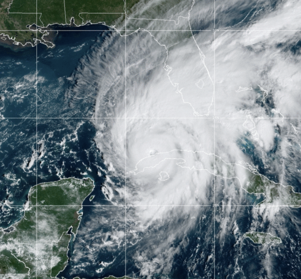
The images, released by the US National Oceanic and Atmospheric Administration (NOAA), showed tightly-packed storm bands rotating north after the eye of the hurricane passed over western Cuba on Tuesday.
Hurricane Ian crashed into Cuba at 4.30am (eastern time) in Pinar del Rio province, where 50,000 people had been evacuated and authorities had made attempts to save the island’s valuable tobacco crop. Winds reached sustained speeds of 125mph (205 km/h) with storm surge of up to 14 feet (4.3 meters).
At 2pm ET on Tuesday, the National Hurricane Centre (NHC) further sounded the alarm for Florida, announcing that Ian was approaching the western Gulf coast as “an extremely dangerous major hurricane”.
Maximum sustained winds have increased to near 120 mph (195 km/h) with higher gusts.
Recent models are projecting the hurricane to make landfall south of Tampa Bay, an area that has not seen a major storm for more than a century.
Storm surge could reach up to 12ft (3.7m) in the Tampa area. However, due to the size of the storm, which is being supercharged by warm waters in the Gulf of Mexico, large stretches of Florida’s coast are at risk.
Around 2.5 million people have been ordered to evacuate including in Pinellas and Hillsborough counties, home to St Petersburg and Tampa.
Mandatory evacuations were also placed on some parts of Pasco, Sarasota, Charlotte and Lee counties. Most of the central Florida Gulf Coast has some kind of evacuation order in place.
Water is already over the sea wall in Key West. Storm surge here will peak at 2-4 feet. Highest wind gusts could range 60-70mph tonight. #HurricaneIan pic.twitter.com/eGHTHpBXgS
— Brandon Orr (@BrandonOrrWPLG) September 27, 2022
Ian is tracking to move over the southeastern Gulf of Mexico today, pass west of the Florida Keys later tonight, and approach the west coast of Florida as a possible Category 4 hurricane on Wednesday and Wednesday night.
Meteorologist Brandon Orr, from WPLG in Miami, tweeted video shortly before midday on Tuesday showing storm surge pouring over the sea wall in Key West. The region is expected to have surge between two and four feet, and winds up to 70mph.
On Tuesday, Governor Ron DeSantis urged Floridians to heed warnings to evacuate and seek higher ground due to potential for “catastrophic flooding and life-threatening storm surge”.
President Joe Biden had earlier approved a disaster declaration for Florida “immediately upon receiving” a request from Governor DeSantis. The president said that he had spoken with mayors in Tampa, St Petersburg, and Clearwater on Tuesday.
New hurricane watches and warnings were also being issued for neighbouring states of Georgia and South Carolina.
Hotter ocean and air temperatures caused by the climate crisis are amping up hurricanes into stronger - and more destructive - events, scientists say.
According to the most recent assessment from the United Nations’ leading Intergovernmental Panel on Climate Change, global heating is not only making cyclones more powerful but slowing their pace and packing them with added preciptiation which can have dangerous implications for flash flooding and coastal surge.

