
The 12-hour window of extreme weather 'most concerning' to NSW authorities

The Bureau of Meteorology has warned a 12-hour window will be of “most concern” for the Sydney and Central Coast areas as authorities brace for more potential flash flooding.
Jane Golding, from the Bureau of Meteorology, spoke at a press conference about NSW’s ongoing extreme weather conditions on Sunday.
“For the Sydney and the Central Coast area it is really the next 12 hours of most concern [from about 11am],” she said.
Ms Golding said the focus would then shift towards the South Coast, where similar rainfall rates could be expected on Sunday night and Monday.
NSW SES Commissioner Carlene York said more than 800 SES volunteers are out on the field, with 40 flood rescue assistance requests received since Wednesday and a total of 300 jobs called in.
She added powerlines coming down and power services being impacted by the weather has affected the SES’s responses.
#SydneyStorm #NSWSES thank you for acting so quickly to help my parents. pic.twitter.com/wXKVUGsQPp
— Mitchell Hall (@thefountain73) February 9, 2020
“We have to make sure the electricity conditions are safe for us to do our work,” she said.
Comm York said on there had been a lot of flooding through homes as a result of roof damage and fallen trees, urging people to be wary of the electronics in the homes, which could put people in more danger.
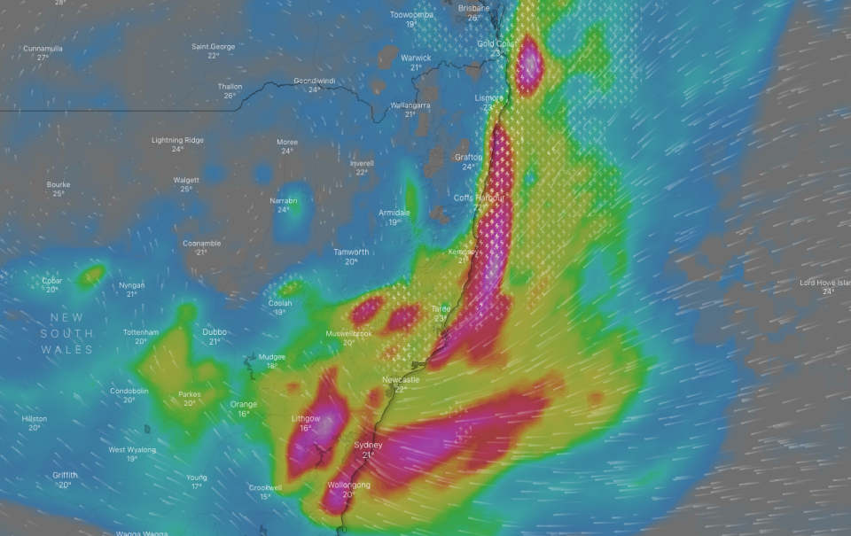
Ms Golding said some areas in NSW received a “couple of hundred millimetres” overnight, some areas receiving almost 300mm overall on Saturday.
The Byron Bay area, near the Queensland border received heavy rainfall overnight, and the Mid North Coast received 250mm in the last 24 hours, Ms Golding said.
She added the gusty winds across the state were a sign the system was intensifying.
“The winds have picked up across the central parts of the New South Wales coast. So down from Newcastle, down to about the Batemans Bay area, we are really seeing those winds start to pick up,” Ms Golding said.
“A few locations along the coast [are] already recording gale force winds, around 70km/h. But broadly, as you go inland, lot of places are getting 50km/h. So some really gusty easterly winds... is a sign of this system intensifying.”
Ms Golding said it was clearing up near the Queensland border after “heavy storms” on Saturday night, but there could be an “outside chance” the area has one or two more storms on Sunday.
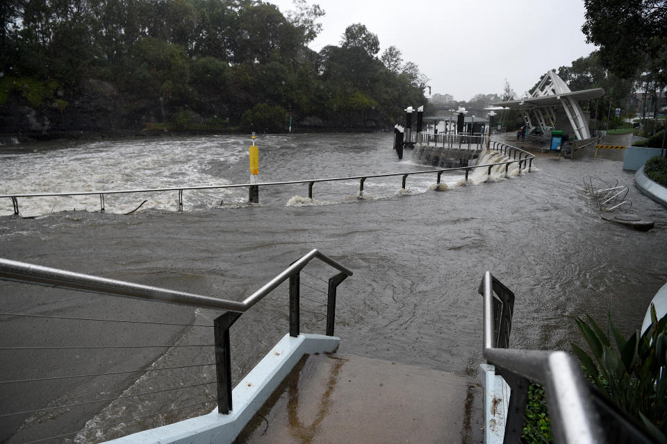
The central NSW coast will receive the peak rainfall amounts on Sunday as will most coastal areas and the eastern ranges, like the Blue Mountains and the Illawarra region, which will be the areas of most concern in the coming hours, Ms Golding added.
"The Illawarra escarpment. Most of those areas will just see ponding of water over roads, which we are seeing at the moment,” she said.
Ms Golding said the places that get “heavy rainfall totals”, which are expected on Sunday afternoon, could see “significant flash flooding”.
She warned the strong winds paired with the king tide could result in coastal erosion.
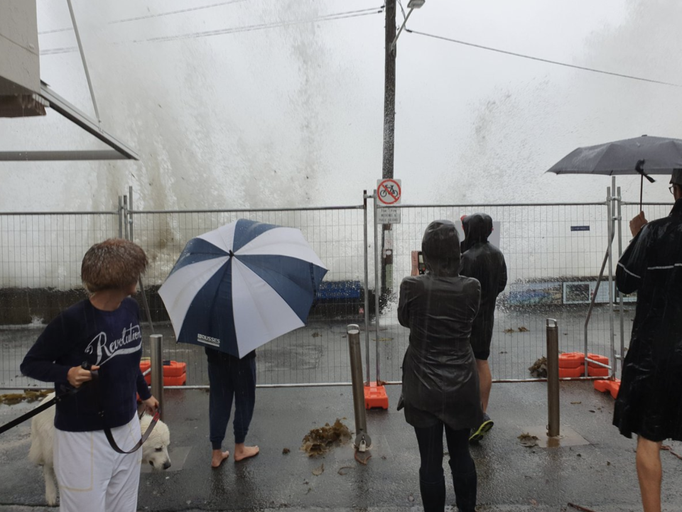
Massive wave overtopping happening at Fairy Bower #Sydneystorm pic.twitter.com/2kyBoiDTUc
— Mitchell Harley (@DocHarleyMD) February 8, 2020
“So, the coastal erosion is really today (Sunday) and tomorrow (Monday), will be the main danger period, because it is really the height of the waves, the power of the waves coming in from the east which erodes the land,” she said, adding there were several “vulnerable areas” on the central and southern NSW.
Earlier, the bureau said in a statement there was "potential for periods of very heavy (torrential) rainfall and life-threatening flash flooding" in the Hunter region, including the Central Coast, as well as the greater Sydney, Illawarra and eastern parts of the Central Tablelands districts, including the Blue Mountains.
‼️‼️GET PREPARED‼️‼️
DAMAGING WIND GUSTS, in excess of 90 km/h, are possible along the coastal fringe between Ulladulla and Forster later today and Sunday.
Stay vigilant and monitor conditions. Get prepared:https://t.co/gLenRSRom5 pic.twitter.com/9HlIIePP2H— NSW SES (@NSWSES) February 7, 2020
Police urge people to stay out of ‘dangerous’ flood waters
NSW Police assistant commissioner Karen Webb said people were not “hearing or adhering” to warnings from emergency services.
“Do not drive into swollen water areas across roadways. It is very dangerous. We have experienced an increase in demand for people driving into flood waters,” Comm Webb said.
“You can't beat those flood waters.”
She said the volumes of water made it “very dangerous” for people.
Comm Webb also stressed the importance of not entering the surf in the intense conditions, adding five men decided to take a fishing boat out on Brisbane Waters at 11.30pm (local time) on Saturday.
“The boat capsized,” she said.

“Fortunately those people were rescued by good Samaritans nearby. But that was very reckless and unnecessary, and put lives at risk.”
In a statement issued by NSW police, Comm Webb said she was “disappointed” she needed to remind people to act responsibly in this weather.
Following a video surfacing on Saturday, police are investigating a man who was filmed jet skiing in floodwaters on the Central Coast, “which is behaviour so reckless I can barely comprehend it”, she said.
Do you have a story tip? Email: newsroomau@yahoonews.com.
You can also follow us on Facebook, Instagram and Twitter and download the Yahoo News app from the App Store or Google Play.


