
Forecasters dumbfounded as rising temperatures lead to winter bushfire danger
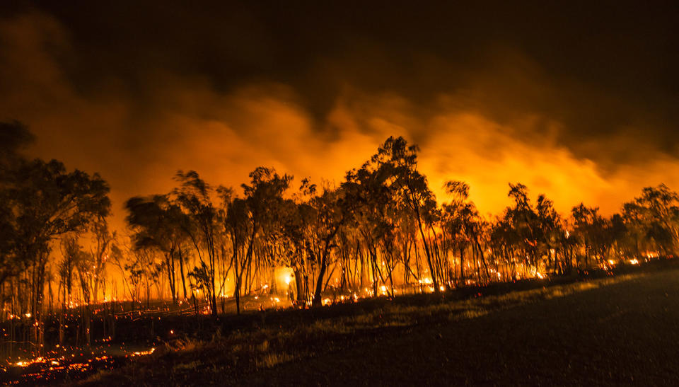
An uncanny mid-winter event has shocked the nation’s weather experts, with bushfire warnings in place in some regions as temperatures soar to the north.
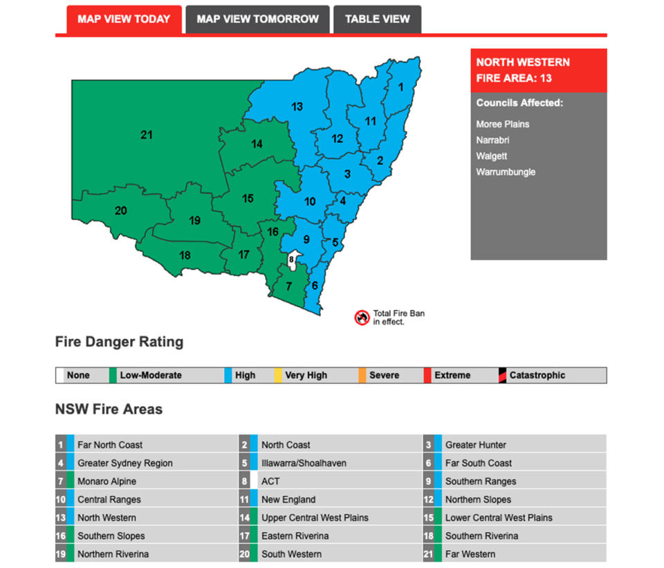
Strong winds and rising temperatures have brought on a severe fire danger warning to the Top End, while some areas of NSW’s Greater Hunter and North Coast could reach a Very High Fire Danger level.

Parts of NSW are likely to see elevated bushfire risks on Tuesday, the Bureau of Meteorology warned.
On Monday, Dubbo was eight degrees above its July average, according to Weatherzone. Similarly, Bourke has felt at least five degrees above the month’s average daytime temperature the past two days, forecasters calculated.
Grafton in the north has experienced more than a week of above July average daytime temperatures.
‘A spell of unseasonable warmth’
“Along the east coast, we’re in the middle of a spell of unseasonable warmth and on Tuesday,” according to Sky News Weather channel meteorologist Tom Saunders.
Areas around Coffs Harbour and Grafton reached almost 26 on Tuesday and are expected to remain in the 20s all week.
Sydney is a few degrees cooler, but still reached an unseasonably high 23.6 degrees on Tuesday, which is 8 degrees above average for this time of year, Mr Saunders said. The temperature will drop to 19 on Wednesday, but still well above normal.
The city’s July average is 16.7C, but this year it soared to an average temperature three degrees above the norm.
The Sunshine State remans warm through mid winter, with Brisbane forecast to reach 26 degrees on Wednesday.
As bizarre as it sounds mid #winter - parts of #NSW are likely to see elevated #bushfire risk today. It's anticipated some areas of Greater #Hunter & North Coast could reach Very High #Fire Danger due to warm temps & strong winds. @NSWRFS active fire map https://t.co/NWE9UC1pGr pic.twitter.com/sr2nKCJuHH
— Bureau of Meteorology, New South Wales (@BOM_NSW) July 22, 2019
Dry winds elevate the risk of fire in the Top End
Meanwhile, severe fire danger warnings are in place for the Darwin and Adelaide River, and Northern Fire Protection Area fire forecast areas, according to Weatherzone.
Despite the unusual winter temperates further south, the forecaster said temperatures over the Top End this month have not been out of the ordinary for this time of year.
“Wind speeds have also been increasing in the north of Australia with a ridge of high pressure strengthening over the region. These dry winds, moderate-to-fresh in strength, may help to quickly spread any fires,” Weatherzone reported.
At 11am, Darwin had already recorded a wind gust of 37km/h.
Conditions should remain warm and gusty at times tomorrow. This could see the increased fire risk continue for parts of the Top End.
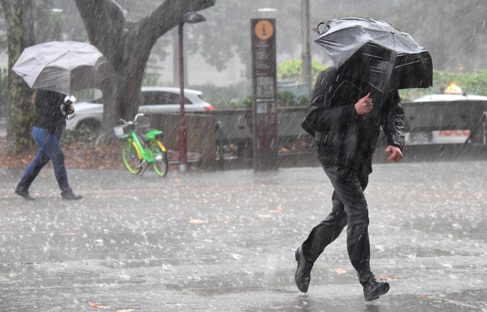
Severe weather to sweep across southern states
A typical winter continues across our southeast, which is experiencing damaging weather conditions.
South Australia, Victoria and southern NSW will be hit with damaging winds on Tuesday afternoon and into Wednesday, the BOM confirmed. It expected gusts up to 120 km/h in elevated areas, and blizzard conditions in Alpine regions.
In Tasmania overnight, snowfall is expected as low as 400m in the south and 600m in the north. The BOM has also issued a flood warning for Tasmania’s Meander River.
“The strong winds will contribute to big and powerful swell along southern coastal areas, with significant wave heights of around 6-8 metres,” the BOM indicated.
⚠️ Minor #Flood Warning updated for #Meander River, for Tuesday evening. A further 5-10 mm are forecast for the remainder of Tuesday with up to 15 mm possible in elevated areas. See https://t.co/V9LYfDAYDq for details and updates; follow advice from @SESTasmania. #TasFloods pic.twitter.com/X4ZkVY8H7R
— Bureau of Meteorology, Tasmania (@BOM_Tas) July 23, 2019
A cold front is bringing wind gusts of up to 120 kilometres per hour to South Australia. The Bureau has issued a severe weather warning for the state's coastal districts with the worst of the conditions expected to hit on Tuesday afternoon.
The front will also bring squally showers and thunderstorms with Adelaide forecast to have up to six millimetres of rain.
Police have urged motorists to drive to the conditions, ensuring they slow down, be alert and pay attention at all times.
Do you have a story tip? Email: newsroomau@yahoonews.com.
You can also follow us on Facebook, download the Yahoo News app from iTunes or Google Play and stay up to date with the latest news with Yahoo’s daily newsletter. Sign up here.

