
'Life-threatening' warning amid flash-floods and torrential rain - and it's not over yet
The Sydney basin has seen its heaviest rainfall in about 20 years in the past few days as communities were hammered by an east coast low that also brought strong winds.
And the deluge is not over yet. Flooding is expected along the entire NSW coast and damaging winds and heavy rain are set to batter the NSW south coast on Monday.
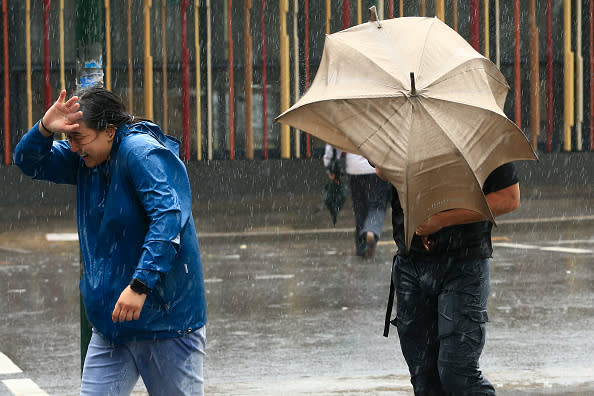
NSW residents who have not been evacuated have been urged to stay home on Monday as “life-threatening” flash-flooding and torrential rainfall continues to lash the state.
Tens of thousands of homes are still without power, more than 50 schools have been closed and some communities north and south of Sydney CBD were forced to flee their homes amid flooding after severe weather plagued NSW on Sunday.

From 9am Wednesday to 5pm Sunday, 250 to 550mm fell over many parts of the Northern Rivers, Mid North Coast, Central Coast, Sydney, Blue Mountains and Illawarra forecast district, with part of the Illawarra receiving falls above 600mm.
Utility companies are rushing to restore power in swamped regions, with up to 150,000 customers without electricity on Sunday night.
Matt Kirby with the SES, which received 10,000 calls for help over the weekend, told the ABC people should work from home or at least reconsider their travel to avoid roads overrun with water.
"We are trying to ask people to reconsider their travel, a number of roads are closed," Mr Kirby said.
"And we are still seeing people driving into floodwater."

Communities along the Hawkesbury and Georges rivers have been ordered to evacuate ahead of surging floodwaters forecast to peak at their highest level in decades.
Major flooding was inundating Milperra and Liverpool in western Sydney in the early hours of Monday, the NSW State Emergency Service said.
There are concerns the Georges River at Milperra could reach levels higher than 1988's flood.
Residents near the Narrabeen Lagoon in northern Sydney have also been urged to leave, with flooding in that area likely to be worse than the damaging flood of 2016.
The Bureau of Meteorology says severe weather conditions are forecast again on Monday with heavy rains, damaging winds with gusts in excess of 90km/h, landslides and damaging surf possible along the state's entire coast.

Flash-flood warning
Torrential rain could create potentially deadly flash-floods in Sydney, Illawarra and the Central Tablelands, the bureau warned.
“There is potential for periods of very heavy (torrential) rainfall and life-threatening flash-flooding in those areas during the morning period,” the BoM said.
“Dry and burn areas of the state are currently particularly vulnerable at the moment, Rain run-off into waterways around these areas is likely to be greater than usual and may contain debris such as ash, soil, trees and rocks. This means flow of debris and landslips are possible during this period.”
NSW Maritime executive director Mark Hutchings says boaties needed to be extremely cautious on Monday.
"Strong and damaging winds have caused power outages around the state and are a threat to moored craft," Mr Hutchings said.
"Winds can cause vessels to break free of their mooring tackle, the rain can fill bilges and debris can entangle mooring lines, cause damage and become hazards to safe navigation."
On Monday, Ausgrid was racing to restore power to up to 13,000 home in northern suburbs of Sydney including Hornsby and Pymble, parts of the Central Coast including Ourimbah, Avoca and Wyong and a number of pockets in Greater Sydney, Newcastle and the Hunter.
"The strong rains and wind have caused more than 2400 hazards to the electricity network such as fallen power poles, large trees across roads, damaged wires and extensive flash-flooding," Ausgrid said.
Endevour Energy had about 19,000 customers without power.
The train had its stopping pattern altered to not include my stop so I came home. This is campbelltown on the way out after about half an hour without any trains. RIP #sydneytrains pic.twitter.com/h33WC1Knr0
— Christine (@Chrissaayyyyy) February 9, 2020
Storms cause commuter chaos
The weather has caused major disruptions to Sydney's public transport networks.
Images show massive crowds of commuters packed onto train platforms.
“Severe weather conditions has affected network infrastructure at various locations,” NSW Transport said.
“Service changes and cancellations may occur at short notice on some lines. Please allow plenty of extra travel time today and send us a message if you need any travel assistance.”
Buses are replacing services between Chatswood and Macquarie Park and there are major delays along the T1 North Shore and T9 Northern Lines.
There is also a partial closure on the Central Coast and Newcastle Line and buses are also being used to replace trains.

Storms threaten Victoria
Devastating storms that ripped through eastern NSW are on their way to Victoria, threatening floods in the state's bushfire-ravaged east.
The Bureau of Meteorology on Sunday issued a severe weather warning for heavy rainfall that will affect most of Victoria on Monday, with downpours expected in East Gippsland.
Rainfall between 25 and 60mm is forecast from early Monday morning to mid-afternoon and emergency services have advised that in fire-affected areas, rainfall might bring debris into waterways and trigger landslides.
Rain started falling across Victorian fire grounds on Monday, providing some relief to firefighters as they prepare for potential damage to roads across the eastern parts of the state.
"We're rapt with the rain that has started to fall across parts of the fire grounds today and have our fingers crossed it continues over the next few days as predicted," the Gippsland Department of Water, Land and Planning said.
"There is a chance though that the increased rainfall could cause a few issues with landslips and road damage in some fire-affected areas again, as we saw a few weeks ago."
Emergency Victoria said crews are on standby to clean up and remove any hazards from the roads, with machinery deployed in fire-ravaged areas like Orbost and Genoa.
"Heavy rain should be confined to East Gippsland, which is a double-edged sword," Emergency Victoria said.
"On the one hand, it's good bushfire extinguishing rainfall. On the other hand, the vulnerable landscape will be at a higher risk of landslips, trees falling, and pollution of debris and ash running into local waterways."
Storms and showers are expected around almost all of Victoria until Saturday.
Downpour continues in Queensland
Showers and possible thunderstorms are forecast for large parts of Queensland following a weekend of downpours.
Morning showers are likely in Brisbane on Monday and Tuesday as well as on the Gold Coast, where most of southeast's wet weather is expected including up to 35mm of falls, Bureau of Meteorology forecaster Peter Markworth said.
Rain is also forecast for the Cape York Peninsula with a monsoon off the coast, while Thursday Island could see up to 70mm over Monday and Tuesday.
Mactier street at Narrabeen under water #sydneystorm #narrabeen #northernbeaches pic.twitter.com/go8EQUZ1Pu
— Angelina (@angesoutham) February 9, 2020
Western parts of Queensland are forecast to stay dry throughout the week, and a trough is preventing rain heading to the state's southwest region.
There is good news for the drought-stricken southern interior, however, where further falls are forecast to start the week.
Up to 15mm of rain could fall in the town of Stanthorpe, which officially ran out of drinking water in January and had to start trucking in water from a nearby dam.
Southern Downs mayor Tracy Dobie said Stanthorpe's main water supply, Storm King Dam, recently had a month's worth of drinking water flow into it.
She said the dam would need six months' worth of water for water trucking to cease.
Tropical cyclone Damien dissipates in WA
Former tropical cyclone Damien has dissipated after lashing the West Australian coast with destructive winds over 200km/h.
The tropical low is still producing strong winds and showers as it moves south after making landfall in the Pilbara region on Saturday.
Only in Australia 🙄 pic.twitter.com/zfcdgQXUEk
— Amanda Rose (@TheAmandaRose) February 9, 2020
The WA Department of Fire and Emergency Services advised that it may still not be safe to return home, urging residents to continue monitoring weather warnings.
"Some services such as power and telephones may not be working and service providers will be working to restore these as soon as they can,” the DFES said.
Severe Tropical Cyclone Damien reached the coast near Dampier on Saturday afternoon, bringing fierce gales to the industrial port and nearby Karratha.
A severe weather warning remains in place for the eastern Gascoyne and northern Goldfields where damaging winds and heavy rainfall are expected to continue.
Those areas could experience 24-hour rainfall totals in excess of 200mm on Monday and Tuesday, the weather bureau as warned.
Flood warnings are in place for the central Pilbara and Gascoyne regions.
With power outages continuing, parents are advised to check if their child’s school is open tomorrow before sending them. Many schools may still be impacted by power outages and flash flooding. #SydneyStorm pic.twitter.com/QH5aqnZIuO
— Ausgrid (@Ausgrid) February 9, 2020
Damien has been the most significant cyclone in the Dampier-Karratha region since Cyclone Orson in 1989, according to the Bureau of Meteorology.
Karratha Airport recorded wind gusts up to 195km/h as well as sustained destructive winds for two hours either side of the cyclone's eye, and 235mm of rain in the 48 hours to 9am Sunday.
Footage of the storm shows branches being ripped from trees and heavy rain being whipped sideways by the strong winds.
Locals have also reported a number of buildings lost their roofs.
Damien was the third cyclone of the season off the WA coast.
Do you have a story tip? Email: newsroomau@yahoonews.com.
You can also follow us on Facebook, Instagram and Twitter and download the Yahoo News app from the App Store or Google Play.


