
Southeastern US tornado, flash flood risk to continue through Monday evening


A severe weather threat that began over the weekend will continue along the Southeast coast through Monday evening, AccuWeather forecasters say.
The first round of severe weather erupted from Saturday afternoon to Saturday night, and brought hail and heavy rainfall to central Texas. Hail up to the size of golf balls occurred. On Sunday and Sunday night, a second round of severe storms brought hail up to the size of baseballs from eastern Texas to southwestern Mississippi.
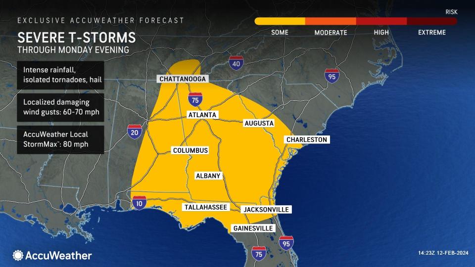
By Monday morning, the severe weather from over the weekend had congealed into a large swath of downpours across Alabama, Georgia, the western Florida Panhandle and into the Carolinas. Several flash flood warnings were in effect in this corridor with reports of street and river flooding.
 |
Flooding downpours are expected to remain a concern through the evening hours as the swath of downpours slowly progresses eastward and expands northward.
There is the potential for isolated spin-up tornadoes embedded within severe thunderstorms, with the greatest risk for this to occur being across the Florida Panhandle, southeastern Georgia and southwestern South Carolina. Hail and damaging wind gusts can also occur in the strongest storms.
"Flight delays are likely to tally up at airports such as Atlanta Hartsfield-Jackson International, the busiest airport in the world, as heavy rain and thunderstorms continue through Monday," explained AccuWeather Meteorologist Alex DaSilva.
Travelers along interstates 10, 20, 75 and 95 can anticipate slowdowns as the rain and thunderstorms cross the region. Motorists will also need to be wary of areas of standing water or debris on secondary roadways.
Have the app? Unlock AccuWeather Alerts™ with Premium+
The storm is expected to blanket a large part of the Northeast with half a foot to a foot of snow and major travel problems from Monday night to Tuesday.
Meanwhile, locations across the South Central and Southeast will trade the stormy pattern of late with calmer and drier conditions as a zone of high pressure arrives in the wake of the storm.
Want next-level safety, ad-free? Unlock advanced, hyperlocal severe weather alerts when you subscribe to Premium+ on the AccuWeather app. AccuWeather Alerts™ are prompted by our expert meteorologists who monitor and analyze dangerous weather risks 24/7 to keep you and your family safer.
