
Major rain warning as mercury plunges
Sydney has shivered through it’s coldest day of the year so far as Aussie states brace for falls of up to 60mm of rain.
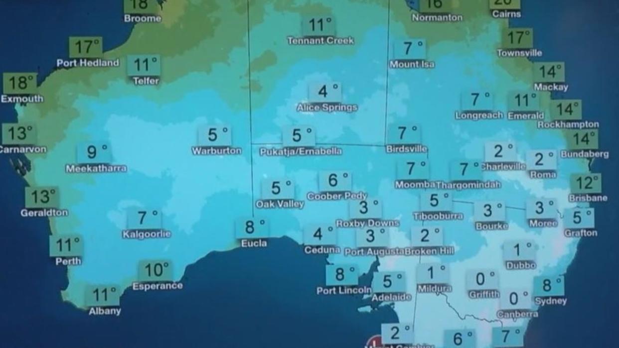
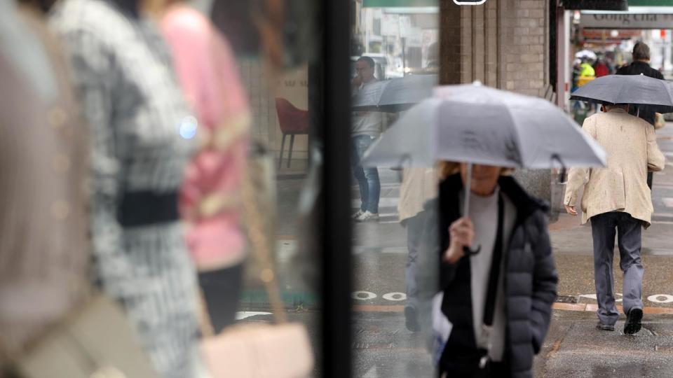
The NSW capital reached just a maximum of 11C on Saturday - feeling like just 7.2 degrees at midday alone - in what has been called a freezing weekend across the country.
But a new weather system originating from the Southern Ocean, about 3000km southwest of WA, is set to lash multiple states with between 20-60mm of rain from next Wednesday.
A second round of showers, isolated thunderstorms and gusty winds are forecast for parts of WA until next Saturday, South Australia on Friday and Saturday, and Victoria and Tasmania over the next weekend.
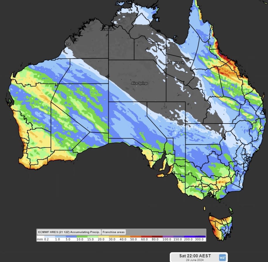
Weatherzone states these systems could deliver widespread falls of 5-15mm during the next 7 days.
Several regions could cop between 20-60mm, with the heaviest being in the coastal and mountainous regions.
It follows a shivering Saturday for Sydney, where the mercury did not exceed more than 12 degrees.
Even Canberra exceeded this with 11.3 degrees being recorded, but with much chillier “feels-like” temperature of 4.6 degrees.
Earlier, the BOM announced another chilly weekend is set to hit Aussies in NSW, Victoria, Tasmania, South Australia and the nation’s capital, with some showers sprinkled in to really hit the winter weather home.
Low pressure areas that have been sitting along the Tasman Sea all week will continue to bring cool, southerly winds along Australia’s lower east coast on Saturday.
“It’s going to be another cool and frosty weekend for many areas,” meteorologist Angus Hines warned.
“On Saturday, those winds will be carrying a few showers for eastern Victoria and the NSW coast.
“On the other side of the country, we’ve got a cold front arriving in Perth early on Saturday morning … a spell of showers with a possible thunderstorm, maybe a little bit of hail and some cool gusty winds pushing through.”
Rainfall is also expected on the Queensland coast on Saturday afternoon, from Brisbane all the way to Cairns.
As for the chilly weather, it’ll sadly continue with many places in the low single digits such as Dubbo and Moree in NSW, Adelaide, Canberra, and Roma and Mount Isa in Queensland. Launceston in Tasmania will be particularly brutal, with the area forecast to hit -1C on Saturday morning.
“No surprises that it will be another chilly start to Saturday morning. Frost temperatures are expected on the east coast,” Mr Hines said.
“Don’t expect to get higher than 16 or 17 degrees if you live in Tasmania, Victoria, NSW, ACT and even South Australia.”
NSW
Minor flood warnings have been issued for the Hastings River, the Cooks River and the St George Basin for Saturday and Sunday. The bureau is expecting the Hastings River at Settlement Point to reach the minor flood level of 1.2m.
Strong wind warnings have also been issued for the Macquarie, Hunter, Sydney, Illawarra, Batemans and Eden coasts for Saturday.
In Sydney, it’s partly cloudy with a slight chance of showers and a maximum temperature of 17C.
Victoria
A frost warning is in place for parts of Victoria on Saturday morning, with places like Mallee, Wimmera, Northern Country and North East districts expected to hit -1C.
In Melbourne, it will be cloudy with a slight chance of showers and a maximum temperature of 13C.

Tasmania
A road weather alert has been issued for drivers in Tasmania, with icy conditions making it dangerous to drive on Saturday morning. Affected areas include the Central Plateau, North West Coast, Central North, North East and the Western districts.
In Hobart, it’s cloudy with a medium chance of showers and a maximum temperature of 13C.
Queensland
Strong wind warnings have been issued for the South East Gulf of Carpentaria for Saturday.
The sunny weather continues in Brisbane, with the bureau warning of a chance of smoke haze to hit the area. A maximum temperature of 25C is forecast, with showers expected to hit on Saturday.
Western Australia
Showers are expected to hit Western Australia’s southwest, with gale warnings put in place for the Albany and Esperance coasts on Saturday.
In Perth, the weather is partly cloudy with a maximum temperature of 20C.
South Australia
Frost warnings are in place for parts of SA, where temperatures are forecast to hit -1C in the Mid North Riverland, Murraylands, Upper Southeast and Lower Southeast districts on Saturday morning.
Adelaide will be partly cloudy with a slight chance of showers. A maximum temperature of 16C is forecast.

ACT
The bureau has issued a warning to any sheep graziers about the incoming cold temperatures, showers and southwesterly winds expected to hit on Saturday. Areas affected include the Northern Tablelands, Southern Tablelands and the Snowy Mountains.
Cloudy weather is forecast for Canberra, with medium chances of showers and a maximum temperature of 11C.
Northern Territory
A strong wind warning has been issued for the Beagle Bonaparte and Roper Groote coasts for Saturday.
The sun is shining in Darwin and is set to continue for the next few days, with Saturday’s maximum temperature to hit 32C.

