
Millions to be hit by brutal cold snap
Temperatures have plunged to freezing temperatures in Queensland as a cold front moves across the southern states.
Residents in the sunshine state were shivering on Monday night as the mercury dipped to -7.7 degrees in some parts.
According to the Bureau of Meteorology, it was the coldest July since 2019 in Applethorpe with -4.7C recorded on Tuesday morning and Warwick with -2.3C.
Tasmania has also been battling grim winter conditions with fierce winds in excess of 130km/hr.
Hobart recorded wind gusts of 109km/hr overnight, as damaging winds reached 132km/hr at Mt Wellington.
The Bureau of Meteorology issued a strong wind warning for parts of Tasmania, including the Central North Coast, Banks Strait and Franklin Sound, East of Flinders Island, Lower East Coast, South East Coast and South West Coast.

Sky News meteorologist Bradlyn Oakes said the brutal cold front passing the southern states is responsible for the strong winds.
“Lots of windy weather making its way through, all to do with this cold front that continues to push eastwards as we head through the day today,” Ms Oakes said.
“We’ll see some of that diminish as that pushes through eastwards.
“Severe weather warnings for areas in Tasmania (remain) where we’re going to continue see damaging winds go through.”
The bureau forecasts Sydney will record a low of 8C on Wednesday and 7C on Thursday, while temperatures will peak at 20C.
Chilly temperatures are forecast for Melbourne and Hobart, Wednesday expected to reach a top of 17C in each capital city.
However, the bureau forecasts Melbourne will remain cold on Thursday, reaching a low of 9C and a high of 15C.
It’ll be slightly warmer in Queensland, with temperatures hitting a top of 22C in Brisbane on both Wednesday and Thursday.
Some areas even woke up to below freezing temperatures, including Canberra which recorded -2.0 degrees and Applethorpe in Queensland reaching -4.7 degrees on Tuesday morning.
“This high pressure area that stretches out across the country will lead to cool conditions across our mornings,” Ms Oakes said.
“As the high pressure just sticks around, our mornings are going to be chilly and frosty.”
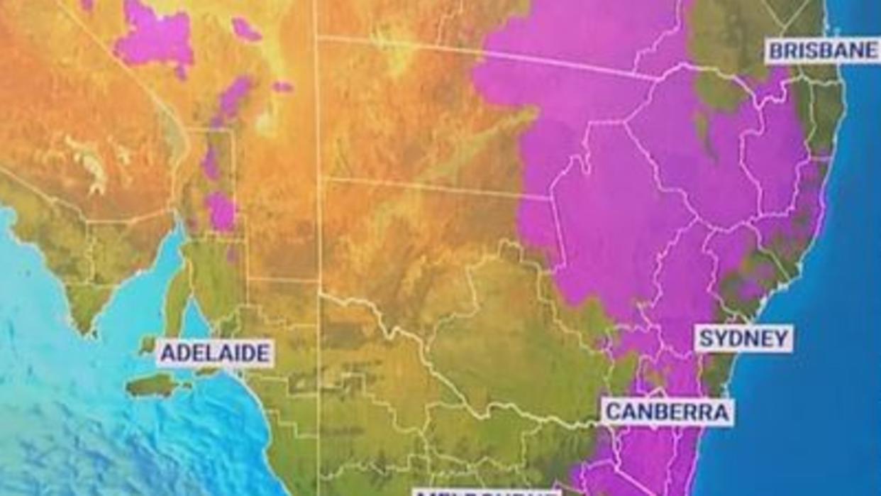
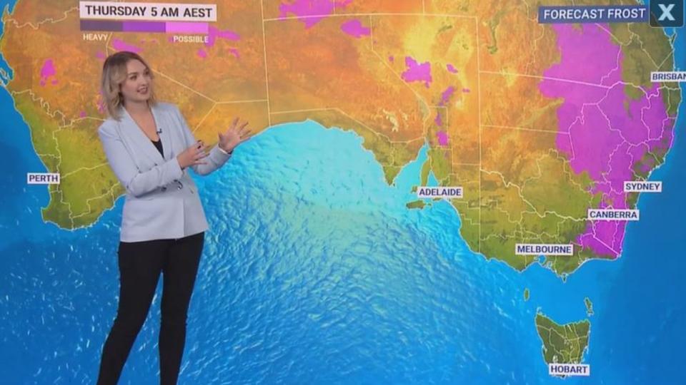
“Widespread frost is expected on Wednesday morning from Western Australia through to our eastern states.
“That hangs on in the east into Thursday.”
Ms Oakes said cold front has brought some “fairly cool temperatures in the morning a few degrees below seasonal” across the country on Tuesday.
Queensland
Temperatures have dropped well below freezing in on the Granite Belt in Queensland, with the temperature dropping to -4.7C at Applethorpe about 6.30am on Tuesday.

Meanwhile, Stanthorpe recorded -4C, temperatures dropped to -2.3C at Warwick.
The bureau confirmed it was the coldest July morning in Applethorpe and Warwick since 2019.
New South Wales
The bureau has also issued a warning to sheep graziers during this cold snap.
“Sheep graziers are warned that cold temperatures and easterly winds are expected during Wednesday,” the bureau warned.
“Areas likely to be affected include parts of the Northern Tablelands forecast district.
“There is a risk of losses of lambs and sheep exposed to these conditions.”
A flood warning is also in place at Barham and Corowa on late Tuesday.
⚠️ Flood #warning updated: Moderate flooding is possible at #Barham from late Tuesday. Minor flooding is occurring at #Corowa, and is possible at Torrumbarry Weir from late Tuesday. Details and updates: https://t.co/Ss766eSCrLpic.twitter.com/1v6R7RPekH
— Bureau of Meteorology, New South Wales (@BOM_NSW) July 11, 2023
Western Australia
Ms Oakes said the cold front will continue to strike the southwest as it makes its way towards the east, bringing frosty mornings all week long.
“This first frontal zone is going to just skirt by bringing a couple of showers as we head through our Tuesday,” she said.
“There’s also another frontal zone that will push into the southwest into Wednesday, which could bring a few showers into Perth on Wednesday and Thursday.

