
Flash flooding warnings as slow storms hit

NSW’s northeastern coast was lashed by slow-moving thunderstorms throughout Monday, with warnings a new deluge of “intense” rain will stick
A southeasterly surge in NSW’s Northern Rivers has led to warnings of severe thunderstorms and persistent rain that could result in flash flooding.
Locations on high alert include Lismore, Casino, Kyogle, Evans Head, Maclean, and Ballina, where slow-moving storms pelted the area with more than 70mm on Monday afternoon.
The Bureau of Meteorology warns the trend will likely continue this week, with forecasts of severe thunderstorms for the state’s mid-north coast, lower west and upper west forecast districts.
Slow-moving thunderstorms brought more than 70 mm in Ballina this afternoon. A severe thunderstorm warning is still current in much of #NorthernRivers. Latest warning https://t.co/tYiUXby2yrpic.twitter.com/7GlL0V7GH9
— Bureau of Meteorology, New South Wales (@BOM_NSW) January 15, 2024
In Queensland, the potential of severe thunderstorms will lash the north, far north and northwest on Monday, as monsoon weather takes hold.
Areas in the far southwest, near the NSW border could also experience heavy storms, with the potential for the lightening and thunder to spread across most of the state.
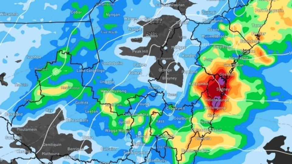
On Monday morning, meteorologists warned that residents in Sydney, the Illawarra and Central Coast regions are particularly at risk as a coastal trough meets a highly moist south-easterly wind flow, which has intensified rain in the area.
Rain has already caused areas of Sydney to come underwater, with the Bureau of Meteorology issuing a severe thunderstorm threat for the city as well as Newcastle and Wollongong overnight to Monday morning.
Sydney’s inner west was particularly affected with parts of Concord Rd and Homebush Bay Drive closed in sections as they became inundated with water.
The Bureau has cancelled its warning but has stressed it will continue to monitor the situation as new storm cells may arise.
The Sydney metropolitan area will continue to come under threat throughout Monday as well as areas north of Batemans Bay, and Illawarra and Central coast also at risk of heavy falls according to WeatherZone meteorologist Yoska Hernandez.
“Residents in these regions are urged to exercise heightened caution as 60-80mm of rain is anticipated, mainly falling during the morning and afternoon,” she warned.
“If thunderstorms or particularly heavy showers develop, some coastal and adjacent inland areas could potentially receive 80-120mm.”
The strongest part of the wet weather system will start to shift north later on Monday, transitioning into lighter showers as the day progresses.

“Meanwhile, the Mid North Coast and Northern Rivers districts are likely to experience the most substantial rainfall in the afternoon and evening,” Ms Hernandez said.
“In other regions along the NSW coast and adjacent inland, falls of 30-60mm are expected during Monday, with isolated heavy downpours also possible for parts of the Mid North Coast, with the potential for rainfall exceeding 100mm.”
Despite showers easing, another 20 to 40mm of rain is projected to fall across the NSW coast, and the wet weather is likely to persist until Friday.
Meanwhile, warmer than usual ocean temperatures have caused record-high humidity in Sydney, with the sticky conditions also felt in Brisbane.
It comes as severe weather continues to plague Queensland, with those in southeast areas of the state inundated with rain along with monsoon affected residents in the far north.
The hardest hit areas remain in the north, where some flood affected areas will be hit with up to 30mm of rain each day this week.

Flood watch remains in place for the Cape York Peninsula and parts of the Gulf of Carpentaria as flood warnings are enacted for the Paroo, Tully, Murray, Barcoo, Bulloo and Diamantia Rivers.
A major flood warning has been enacted for the Paroo River around Eulo, as the rain pushes river levels to rise “significantly.
“The Paroo River at Eulo is currently at 3.80 metres and expected to be rising slowly, with moderate flooding (moderate flood level 3.00 metres),” the Bureau warned.
“The Paroo River at Eulo may peak around the major flood level (4.00 metres) overnight Sunday into Monday.”
Brisbane will also be impacted by showers throughout the week, with up to 10mm expected to fall on Monday and Tuesday despite temperatures in the high twenties.

