A dayslong siege of rain is fueling a serious flash-flood threat in the South
A multi-day siege of heavy rain and thunderstorms is raising the risk of flash flooding across the South, while freezing rain creates potentially perilous travel conditions for parts of the central US on Tuesday. Here are the latest updates:
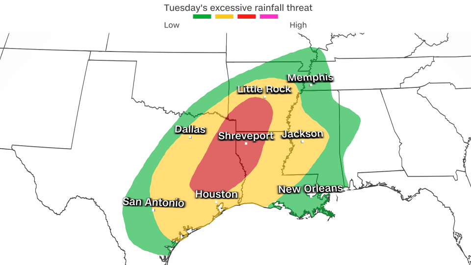
• Heavy rain brings flash flooding to South: More than 30 million people are under flood watches that stretch from eastern Texas to the Tennessee Valley. More than 5 inches of rainfall could inundate drought-stricken areas this week, overwhelming dry soil and triggering additional flooding. Heavy rainfall Monday unloaded flash flooding in Texas, including San Antonio.
• Wintry mix poses travel threat: Freezing rain and scattered snowfall could lead to ice-glazed roadways and some power outages through Tuesday night from parts of the Midwest to the interior Northeast. Air travel may be hampered by icy weather after similar conditions on Monday led to spikes in delays and cancellations at airports including Chicago’s O’Hare International Airport and St. Louis Lambert International Airport.
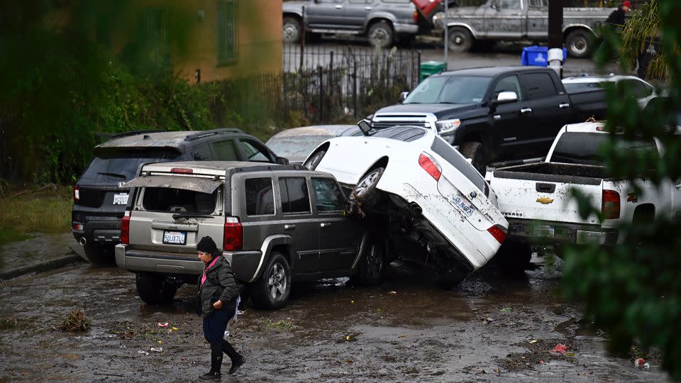
• Hundreds rescued in California flooding: Winter storms continue to pummel the West. Cleanup and recovery is underway Tuesday in San Diego, where the mayor has declared a state of emergency after heavy rain sent several feet of fast-moving water rushing through some streets and prompted hundreds of rescues on Monday, officials said. Damage assessments are underway in the region and temporary shelters have been established for the displaced and homeless. Gov. Gavin Newsom on Tuesday declared a state of emergency in San Diego and Ventura counties to support recovery from recent storms.
Serious flash flood threat in the South
Daily waves of warm, moist air will fuel rounds of drenching storms for the South through midweek before wet and dreary conditions expand to a wider area of the eastern US by Friday and Saturday.
Moisture surging north from the Gulf of Mexico is increasing the flood threat across the South.

The heaviest rainfall and the greatest risk for flash flooding will be Tuesday and Wednesday over some of the most parched areas of the region, including Louisiana and Mississippi. Level 3 out of 4 risks of excessive rainfall are in place for both days.
Widespread rainfall totals of 4 to 6 inches are likely. Higher totals will focus on areas closer to the Gulf of Mexico where multiple rounds of heavy rain and a few thunderstorms unfold. Parts of Louisiana and Mississippi could end the week with rainfall bordering on double digits.
Rainfall of this nature can easily lead to flash flooding, especially in drought-stricken areas, because the ground is dry and hard, allowing less water to soak into the soil.
Drought conditions cover more than 80% of Mississippi and more than 90% of Louisiana, and over 10% of both states are in exceptional drought – the most severe level of US Drought Monitor scale.
While the rain will become less intense after Wednesday, steady rounds of rain will persist for the entire week across parts of the South.
By Friday and Saturday, rain and will expand tremendously in scope, bringing dreary, wet weather across much of the East.
Around 1 to 2 inches of rain is possible during this time from the central Appalachians through New England.
Icy roads threaten travel woes
About 13 million people are under winter weather alerts across the Great Lakes and Northeast on Tuesday as a storm that wreaked icy chaos begins to wind down.
After slick roadways led to reports of cars losing control or spinning out on Monday, accumulating ice remains a threat Tuesday. Even small coatings of ice are enough to cause issues on untreated, paved surfaces like roads and sidewalks. Larger build-ups can also cause tree damage and cause power outages.
Several regional National Weather Service offices urged people to avoid driving in hazardous conditions or exercise extreme caution if travel is essential.
The weather service in Indianapolis, Indiana, cautioned that though air temperatures will be slightly above freezing, ice can still coat roads and sidewalks. “If traveling, drive slow and safe!” the agency said.
Winter weather alerts last into Wednesday for parts of New York and New England.
Mopping up in water-soaked San Diego
Monday’s rainfall and flooding in San Diego were “unprecedented,” Mayor Todd Gloria said Tuesday. He said he toured the communities in the southeast areas of the city most impacted by rain and flooding.
Monday was ranked as the fourth-wettest day on record in San Diego, with 2.73 inches of rain, according to the National Weather Service.

“The damage and the impact were absolutely devastating, in fact, it was heartbreaking,” Gloria said at a news conference.
“I saw homes that were destroyed by floodwaters, floodwaters that reached the ceilings in some cases. I saw cars that had been picked up and moved down the street, floated away from where they had been parked, got swamped with water and with mud.
“I saw entire lives changed in just a few minutes, and I want to let folks know my heart is with them, and I ask San Diegans to hold every one of your neighbors in your hearts who are having to deal with yesterday’s events.”
Gloria said those residents most affected by the storm will be in recovery mode for weeks, if not months.
He encouraged residents to assess damages, file claims with their insurance and report issues to the county.
Initial assessments indicated Monday’s rainstorm caused $6 million to $7 million in damage to the city’s infrastructure, said Chris Heiser, director of San Diego’s Office of Emergency Services.
CNN’s Cindy Von Quednow and Joe Sutton contributed to this report.
For more CNN news and newsletters create an account at CNN.com


