
‘Damaging’ winds and snow hit east

Strong winds have ripped through parts of NSW and Victoria as winter begins to set in across Australia.
The two states experienced the damaging winds, showers and highland snow on Wednesday as a cold front moved in.
“A cold front and associated low pressure system will drag showers and cold air across southeastern Australia on Wednesday,” WeatherZone meteorologist Ben Domensino said.
“Westerly winds will strengthen ahead of the approaching front, before a burst of colder and gusty southwesterly winds sweep through in the wake of the front.”
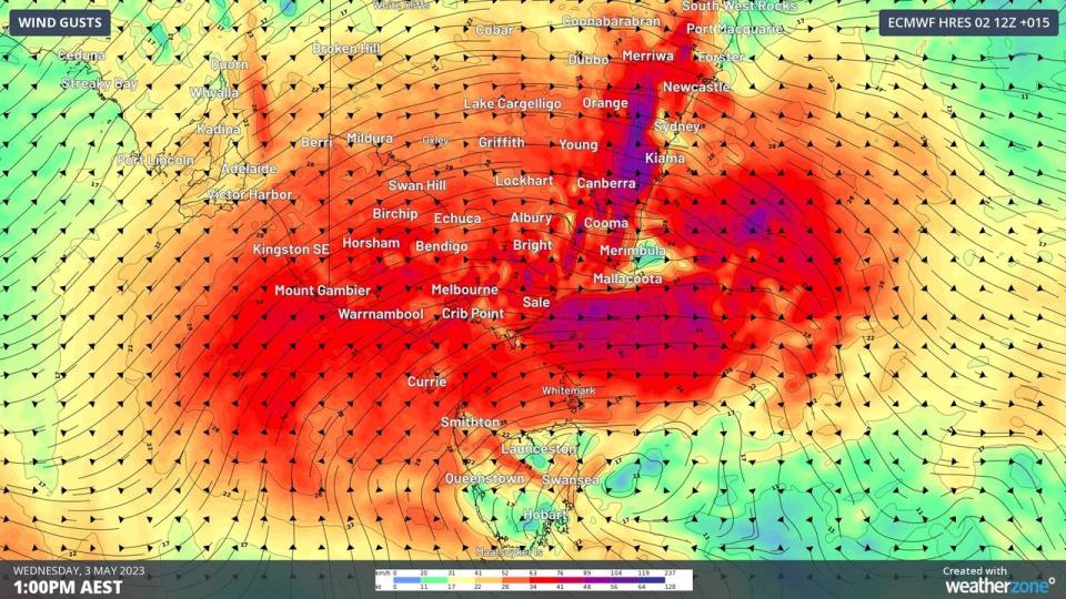
Victoria saw the strongest winds in elevated and exposed coastal areas while the ranges in southern and central NSW as well as parts of the ACT also experienced the icy blasts.
Many places experienced wind gusts over 110km/h early on Wednesday morning.
These included Mt Buller which saw 119km/h gusts, and Thredbo Top Station and Frankston Beach which each had winds of 115km/h.
Sydney and Melbourne experienced much weaker winds of up to 30km/h throughout the day which dropped off to 20km/h in the evening.
Showers fell and are expected to continue across most southern, central and eastern districts of Vic and southern NSW/the ACT.
“There could also be a few thunderstorms in southern Vic as the front sweeps through, which bring an additional risk of isolated damaging wind gusts,” Mr Domensino said.

