
Cyclone, thunderstorms set to smash Aussies

Dangerous gales and wind gusts of up to 90kmh are expected to hit WA today as ex-Tropical Cyclone Lincoln moves towards the coast from the Indian Ocean.
The Bureau of Meteorology warned Australians near the town of Exmouth in the state’s North West Cape and Gascoyne areas to prepare for the severe winds from late morning.
“Gales with damaging wind gusts of 90kmh may develop later this morning in the Exmouth-Ningaloo region then south to Coral Bay, and possibly to Cape Cuvier later in the day,” the bureau states.
“Heavy rainfall is likely to be confined to near the path of the cyclone, developing along the Gascoyne coast during the day, and then extending southward tonight.”
“Higher than normal tides are expected between Exmouth and the Shark Bay area.”

A “yellow alert” is now in place for people in or near coastal communities and offshore islands between North West Cape to Cape Cuvier.
The alert means residents need to take action to prepare themselves for the event, including by securing property and household items and preparing emergency kits.
Meanwhile, the bureau also expects to see severe weather strike North Queensland across Saturday, with severe thunderstorms and heavy rainfall concentrated around the town of Tully between Cairns and Townsville.
“Severe thunderstorms are likely to produce heavy rainfall that may lead to flash flooding in the warning area over the next several hours,” the bureau stated on Saturday morning.
“Locations which may be affected include Tully.”
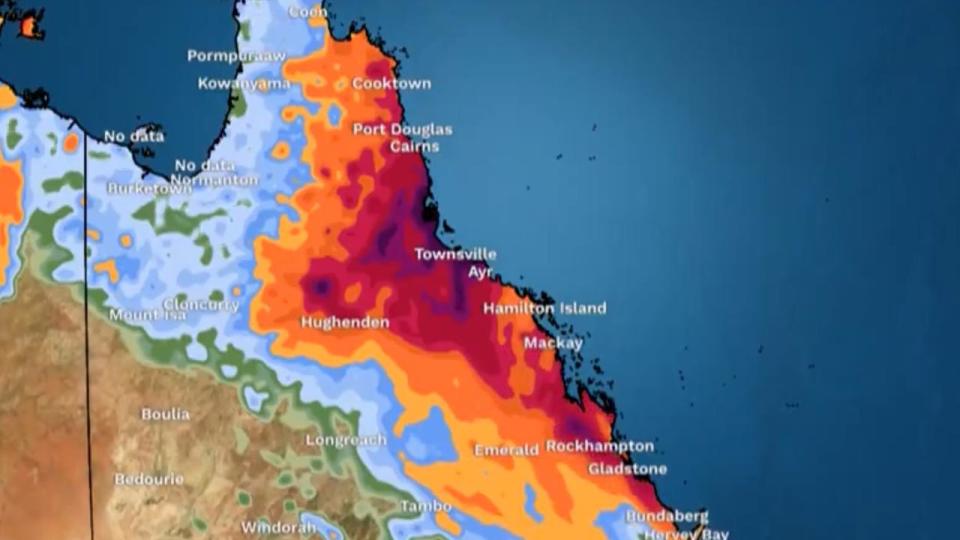
Recent rainfall observations in the region include 271mm in six hours at Bulgun Creek, 280mm in six hours at Tully, 238mm in six hours at South Mission Beach and 192mm in six hours at Murray Flats.
Queensland’s emergency services advise residents in the area to “go inside a strong building now” and “stay inside until the storm has passed.”
Residents are also advised to park their cars undercover away from trees, close doors and windows and avoid driving on roads.
The severe weather comes only weeks after ex-tropical cyclone Kirrilly tore through the same region.
The trough is expected to drive the rain southward into Sunday, the bureau states.
Rainy weather is also predicted for Sydney as Taylor Swift mania grips the city this weekend, though there are no warnings in place for the city.
BOM says there is a “60 per cent” chance of rain for Sydney on Saturday but the clouds are expected to clear by the evening.

