
Chance of new cyclone’s landfall revealed

A tropical low bearing down the east coast has a roughly 40 per cent chance of crossing into one state should it form into a tropical cyclone, with Aussies facing a dual front of storms and heat over the coming days.
A low intensity heatwave warning remains in place for swathes of Queensland but temperatures are forecast to skyrocket to the mid-forties in some parts of the state from Monday.
Maximum temperatures in Brisbane could reach 31C today, then jump to 35 by next week.
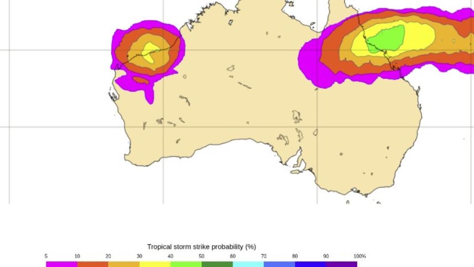
The rising mercury is in addition to a tropical low in the Coral Sea, northeast of Cairns, which is likely to develop into a tropical cyclone by Sunday.
The system, which will be named Kirrily once it forms, will be the second cyclone named in the Australian region so far.
Models produced by WeatherZone forecast the system to move south or southwest between Sunday and Tuesday and remain well away from the east coast.
Another, from the European Centre for Medium-Range Weather Forecasts (ECMRWF), gives the system a 40 per cent chance of crossing into Queensland.
“However, the movement and strength of the tropical cyclone becomes less certain from Wednesday onwards,” a WeatherZone spokesman said.
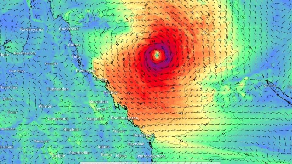
“Some models predict the soon-to-be cyclone will track in a westerly direction towards the Queensland coast from Wednesday or Thursday.
“Others models expect it to move in a south-easterly direction, taking it further away from Australia.”
Queensland Premier Steven Miles has nevertheless urged people in the northern part of the state to be prepared for the cyclone should it make landfall.
It comes after a freak summer season plagued by heavy rainfall and storms across the state, with the north and far north regions hardest hit by ex-Tropical Cyclone Jasper over December.
More heavy storms soaked parts of the state in January.
While Queensland’s heatwave has been classified as low intensity, parts of Western Australia are enduring scorching temperatures of up to 49C.
Kalgoorlie is expected to get to 38C on Saturday, 41C on Sunday and 43C on Monday.
In the Northern Territory, “dangerous and life-threatening” flooding has been forecast from a tropical low hanging around the Top End.
Six hourly rainfall totals of 80-120mm are likely, the BOM has said in a severe weather warning, which could easily lead to flooding.
But the more immediate danger lies at Tennant Creek, with as much as 180mm falling in just hours in some parts.
Darwin could experience storms of up to 9mm on Saturday with highs of 33C.

