Tropical rainstorm racing away from northern Caribbean after unleashing heavy rain
AccuWeather meteorologists say the door for a tropical rainstorm to become the next named system in the Atlantic basin had slammed shut by Saturday as the feature raced away from the northern Caribbean islands.
The feature was designated by the National Hurricane Center (NHC) as Potential Tropical Cyclone 22 at 4 p.m. EST Thursday due to the system's better organization. By Friday evening, the final advisory was issued as the storm lost that organization well to the northeast of Montego Bay, Jamaica. The feature was tracking to the northeast at over 20 mph as of early Saturday morning.
AccuWeather forecasters will continue to refer to the system as a tropical rainstorm through Saturday to emphasize the risks to lives and property as a result of heavy rainfall.
 |
By Saturday night, the risk of tropical downpours will greatly diminish across eastern Cuba, Hispaniola and the southeastern Bahamas as the rainstorm races northeastward.
During the end of the week, wind shear became too disruptive for the rainstorm to organize and become a tropical depression or storm, despite the feature sitting over an area of very warm waters.
AccuWeather meteorologists had warned the public days earlier that wind shear could ultimately be an inhibiting factor to the feature becoming a full-blown tropical system and that, regardless, flooding rainfall would be the main risk to life and property across the northern Caribbean islands.
The next storm to take shape in the Atlantic will be named Vince, and then only the name Whitney will be left on this season's list of names.
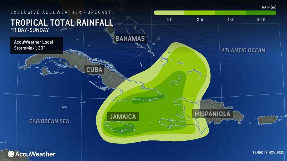
AccuWeather meteorologists are projecting a wide swath of 4-8 inches (100-200 mm) of rain across Jamaica, southeastern Cuba and western Haiti. The AccuWeather Local StormMax™ is 20 inches (510 mm).
 |
The combination of heavy rain and mountainous terrain on the larger islands of the Caribbean will raise the risk of dangerous flash flooding and mudslides.
Cruise and fishing interests from Jamaica to the southeastern Bahamas may want to follow the system's progress as there is the potential for sudden gusty thunderstorms that could make for rough seas and dangerous conditions.
The system in the Caribbean is not expected to affect the United States as steering winds and a cold front will push the system out into the Atlantic later this weekend to early next week.
Meanwhile, a separate system from the one in the Caribbean unloaded heavy rain and triggered strong winds in South Florida from late Tuesday to early Thursday. The rainstorm dropped more than a foot of rain and produced wind gusts to hurricane-force, or 74 mph, in some locations.
Want next-level safety, ad-free? Unlock advanced, hyperlocal severe weather alerts when you subscribe to Premium+ on the AccuWeather app. AccuWeather Alerts™ are prompted by our expert meteorologists who monitor and analyze dangerous weather risks 24/7 to keep you and your family safer.


