Big Sur to be cut off again as damaged Highway 1 threatened by rain
Communities and businesses stuck between two major landslides on Highway 1 in Big Sur will be cut off from the rest of the state again this week when officials halt convoys in and out of the region temporarily in light of a rainy forecast.
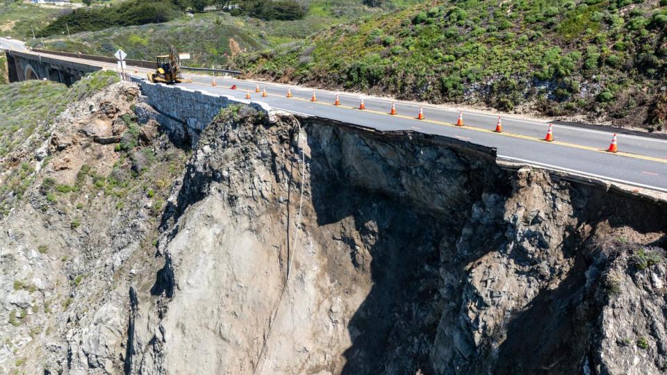
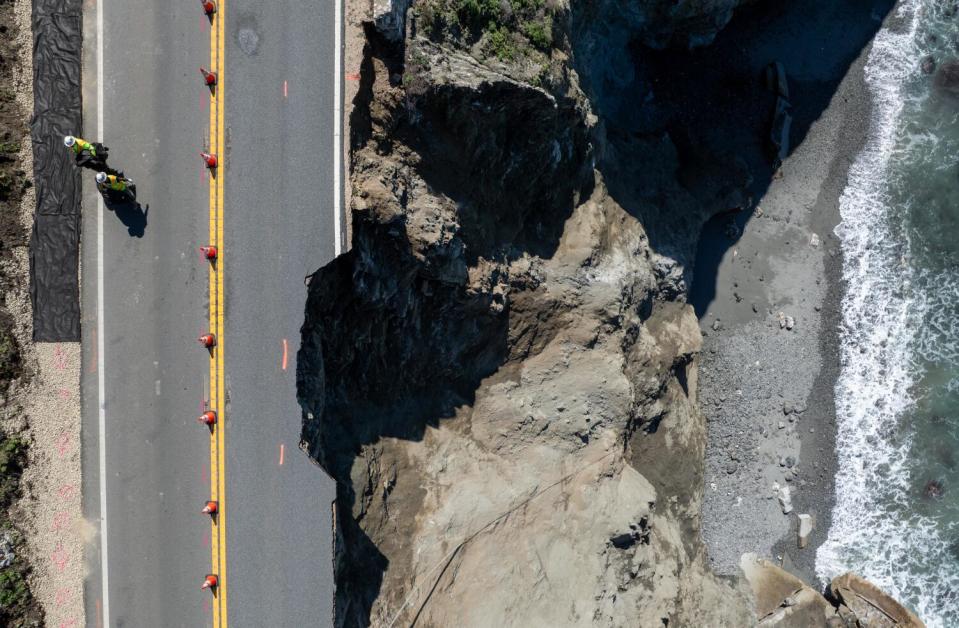
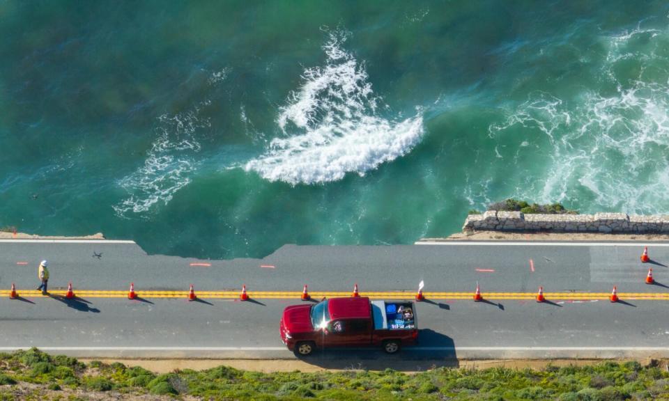
After a massive chunk of roadway fell into the ocean over the weekend in Carmel-by-the-Sea, authorities shut down a stretch of the scenic highway beginning just above Rocky Creek Bridge, about 40 miles north of an ongoing closure that begins near Limekiln State Park.
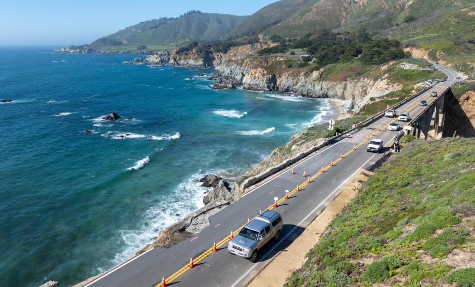
The new closure blocked outside highway access from Palo Colorado Road to Limekiln State Park, but officials have permitted some travel in and out through twice-a-day, regulated convoys on the northbound lane, which didn't see obvious landslide damage. Access is limited to local residents and essential workers.

Both southbound and northbound traffic queue up at the road closures before 8 a.m. and 4 p.m. Officials then escort the vehicles from one direction and then the other. The last two days, about 300 vehicles have taken advantage of the convoys.
Now, however, officials say the convoys will not run Thursday and Friday, and they are urging residents to evacuate, if needed, before another Pacific storm is expected to bring more rain to the region and the road completely shuts down.
The Monterey County Sheriff’s Office issued an evacuation warning Wednesday morning for Big Sur communities ahead of the anticipated showers and thunderstorms, which officials worry could further destabilize or damage the roadway — the only route in or out for an estimated 1,400 residents.
“Emergency Medical Services may be unable to evacuate patients beyond the road closures,” county officials said. County and state officials said a limited number of first responders, including trained volunteers and resident officers, would be positioned inside the route's bookending closures.
The National Weather Service is forecasting rainfall totals of about a half-inch across the Big Sur coastline Thursday and Friday. But thunderstorms could drive heavier rainfall in some areas, meteorologists said.
Read more: Big Sur tourism 'on standstill' after its connecting roadway crumbles into the sea -- again
“We want to be able, in the rain, to keep constant observation of the slip-out and not put any cars on it," said Kevin Drabinski, a California Department of Transportation spokesperson. "It looks as if it has not advanced any more from its original state — which is a good sign — but because it’s such a new event ... and because it was likely caused by saturated ground and recent rain events, we’re going to suspend any travel across the closure area."
Rain has continued to be the culprit of land movement and road hazards in Big Sur, frequently keeping the world-famous highway closed for months at a time.
“We're really doing everything we can to provide limited access that we're comfortable with, but it's really a situation where we're managing the risk," Zeke Dellamas, a California Department of Transportation spokesperson, said Wednesday. "We're cognizant of how much impact this has on the local community, the business community and potentially emergency response here, and we're moving forward as quickly as we can," he said.
In addition to marooning residents, stopping the convoys will continue to cut off businesses from tourism during one of Big Sur's peak seasons.
Saturday's Rocky Creek slip-out, as it is being called, was “a surprise to everyone,” said Patte Kronlund, resident and executive director of the Community Assn. of Big Sur.

“It literally is 200 feet south of a slip-out that happened in 2011, which created same situation of one lane and two traffic lights at either end,” said Kronlund, who is quick to praise the Department of Transportation for assessing and evaluating the damage Sunday.
“They were confident that the northbound lanes road could bear the weight of traffic,” she said, citing at least 2,000 vehicles — “trailers, motor homes, horse trailers” — that used the highway either to head north out of Big Sur on Sunday or to return.
Read more: Part of Highway 1 near Big Sur crumbles as new landslide closes more of historic roadway
Drabinski said Caltrans' goal is to use that northbound lane eventually to run one-lane traffic around the clock, but there's no official timeline for that. Right now, he said, crews are focused on placing 500 feet of concrete barriers along the center line of the roadway to define a channel for vehicles to pass through and ensure the safety of workers, as well as fortify other parts of the roadway.
Then, the real work will begin.
"The first area of focus will be stabilizing the edge of the roadway," Drabinski said. "How can we first address this initial slip-out and get it to a state where it reaches an equilibrium?"
He said engineers and construction crews are working on those tough questions, but he said any permanent solution can happen only after the area is stabilized — which additional rain has been known to disrupt.

Thomas Young, a professional civil engineer based in Roseville, Calif., with extensive experience in highway construction, said officials working on this project will be focused on three things: safety, maintenance and road capacity.
Young, who spoke generally about such construction projects having no direct knowledge of this latest slip-out in Big Sur, said engineers and construction officials will first try to figure out why the slope failed — which he said was probably related to water infiltration. Then, the team will look for further cracking or slippage around the failure to determine how big an area was affected.
Read more: California is building fewer homes. The state could get even more expensive
“Once you get slippage, you never regain the same strength of the hill," Young said. He said there are a variety of solutions to repair such a slip-out, including retaining walls and tieback supports that hold weakened sections of the hillside to a more secure foundation, but that almost all options have a hefty price tag. He would expect the plan will also have to look at drainage and water mitigation.
"At some point it becomes an economic burden," he said, explaining that officials and the public have to weigh the value and burden of such repairs. "It's a fight against nature.... At some point does it become untenable? Yeah. And is that 10 years from now or 1,000 years?"
But residents and businesses to the south of the newly damaged road are dedicated to the area, and the region continues to drive tourism.
Normally more than 1,000 visitors a day are taking in the view and having a meal at the popular roadside destination Nepenthe, according to its general manager, Kirk Gafill.
“There are silver linings” to the current situation, he said over the phone, citing the rare quiet that has fallen on the busy coastline. "But it is not sustainable. It is not realistic for people to live in this community without the highway being open.”
Gafill, who has lived in Big Sur all his life, has been through this before, most notably in 2017, when an atmospheric river undermined the Pfeiffer Canyon Bridge and closed the highway into the Big Sur community for seven months.
Read more: Laguna Beach High School investigates 'inappropriate' AI-generated images of students
“The state estimated that that closure had a $500-million impact on the economy,” he said. “That was over $1 million a day — not just for Big Sur, but for the state entirely. Seven years later — with inflation-adjusted dollars — this closure will add up to even more per day.”
The businesses in Big Sur know what to do during these down times, he said: Make repairs, clean facilities and hope the closure doesn’t last long.
“But we just don’t know,” he added.
The Rocky Creek slip-out is insult to the real injury, said Gafill: the massive slide — known as Paul’s Slide — that buried the highway to the south in January 2023. It's been blocked ever since; the work on Paul’s Slide was expected to be completed by late spring, weather permitting.

In addition, two new slides developed in February in the same vicinity. The larger one, with more than 300,000 cubic yards of dirt, has yet to be cleared, leaving engineers uncertain of the condition of the road. Once work begins on this large slide — contingent on dry weather — Caltrans is estimating it will take three to four months to complete the repair.
“The Big Sur coastline — the community, its businesses, residents and employees — have been impacted economically since 2016 after a series of back-to-back disasters,” said Kronlund, who sees it all starting with the Soberanes fire, which burned for four months in Garrapata State Park, destroying 68 structures and killing a bulldozer operator.
Read more: L.A. Metro's D Line hits a milestone: Tunneling is complete for expansion to the Westside
In successive years, the Big Sur coast and the adjacent Santa Lucia Range have proved to be especially vulnerable to atmospheric rivers and fires, including the 2020 Dolan fire.
In the aftermath of Paul’s Slide, Kronlund estimates that businesses north of the road closure, which includes most of Big Sur, have seen a 35% decline in revenue, while businesses to the south of the slide have seen a nearly 50% decline or greater.
To help families and businesses affected by this closure, the Community Assn. of Big Sur has begun a fundraising campaign through its website, citing the economic damage caused by road closures to the north and south.
This story originally appeared in Los Angeles Times.


