
Australia smashed by extreme weather

While most eyes are on Tropical Cyclone Jasper, wild weather is also expected elsewhere, ranging from heatwaves to heavy rainfall.
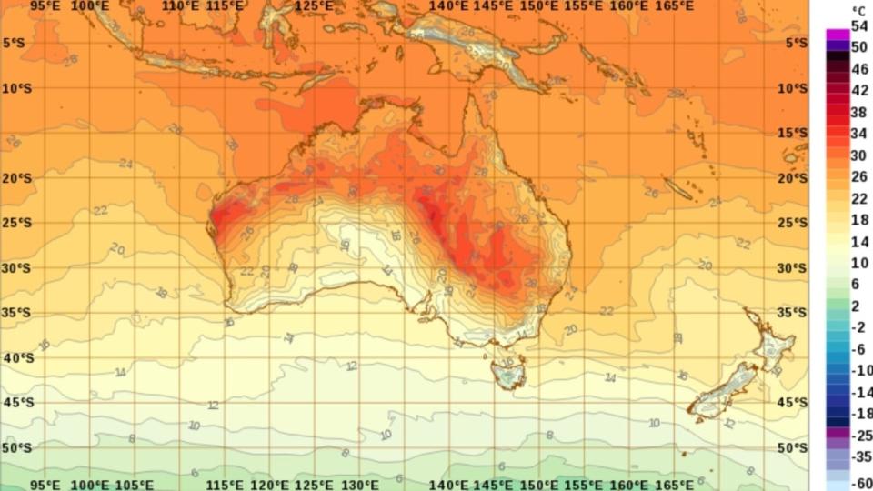
Following sweltering heat Saturday in NSW that saw Sydney reach 40℃ and a max of 44.7℃ in the centre of the state, things are looking a little cooler.
The south western parts of Queensland and inland NSW can still expect to hit that 40℃ mark however with heatwave warnings still in place.
Bondi Beach lifeguard Bruce Hopkins told Today that lifeguards and they got through the first real test of summer largely unscathed.
“Yesterday was really hot,” he said.
“We were lucky though we got away not too bad. We only had one person that had dehydration and a bit of heat exhaustion.
“So, all in all with about 25,000 people down here, we only had one incident that was pretty good.”
Mr Hopkins said even with the weather cooling off they were ready for a big and warm summer season.
“It’s a bit like playing football,” he said.
“Everyone is coming off on holidays and the festive season and we’re ramping it up and ready to go for the hot summer coming along.”
Sky News Weather meteorologist Alison Osborne said the coast of NSW was set for a bit of a reprieve on Sunday which should keep the numbers at the beach down just a little Sunday.
“For the coast you can see the winds coming off the water,” she said.
“That is acting like a nice radiative cooler so we are looking at temperatures nudging the 30 degree mark”
The outlook for Queensland is very similar to that of New South Wales today as the nervously wait for Tropical Cyclone Jasper to male landfall in the coming days.
While parts of NSW and Queensland burn, South Australia and Victoria are seeing some unseasonable weather on the other end of the spectrum, with temperatures below 20℃ and plenty of rain.

South Australia has had a wet 24 hours that has seen it record its December average rainfall in the space of a day and there is still more to come before the system moves on.
There are flood watch warnings in place for areas of Adelaide and much of the Eyre Peninsula and as far north as Coober Pedy for Sunday.
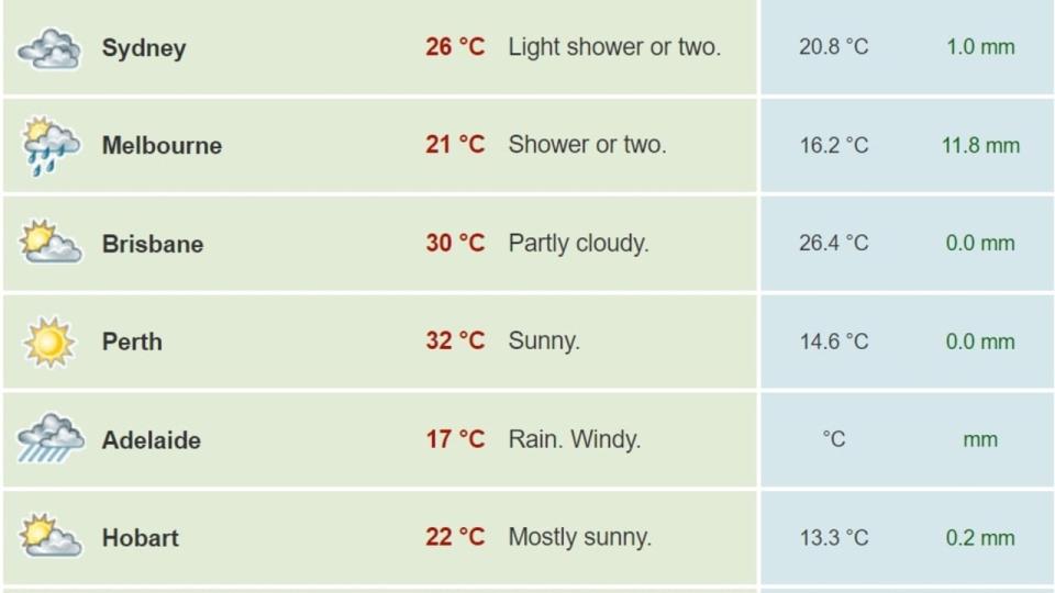
Adelaide is only expecting a maximum of around 17℃ while Melbourne isn’t faring much better with clouds and rain and a max of 21℃.
Out west it is looking ideal with sunshine and temperatures in the low to mid 30s, while the top end can expect stormy weather and rainfall as well as some lightning while also floating around the 30℃ mark.
jordan.mccarthy@news.com.au

