
Australia to be hit by 7 days of storms
Residents in every state and territory are expected to be soaked over the coming week, with severe thunderstorm warnings in place for Queensland and NSW.
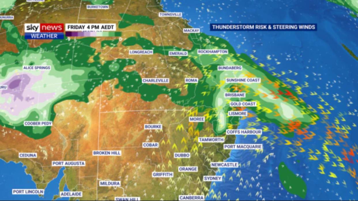
A series of upper-level troughs are expected to trigger rain and thunderstorms across the country this week and next.
The “dynamic” nature of the weather pattern means that meteorologists are finding it difficult to predict just where the rain will fall according to WeatherZone’s Ben Domensino, but Australians should expect the gloomy weather to stick around for up to 10 days.
“At this stage, rain and storms are likely to affect part of every state and territory during the next seven days, with heavy falls possible over Qld, NSW and central Australia,” he said.
“Some of the coming week’s thunderstorms are likely to become severe and heavy rain could cause flash flooding in some states.”
From Thursday, southern Queensland and northern parts of NSW are most likely to be impacted according to the Bureau of Meteorology’s Patch Clapp.


While the storms are likely to be fairly spread out, Mr Clapp warned that those who are hit will be in for some hectic weather.
Mr Clapp said that the storms are likely to be fairly spread out, but those that do get hit could be in for some wild weather and should look to park their cars undercover.
“There is a chance that whatever does get going is going to be big and severe,” he said.
“Some disruptive winds, that’s wind gusts up above 135 km, and possibly, some giant hail as well.
“Even though it’s going to be really scattered and you might miss out Thursday, it could be very severe where the storms do get going.”
Residents in Coffs Harbour, the Gold Coast and Brisbane have been warned there is a chance the thunderstorms could hit them on Thursday, with showers increasing through Friday.
Showers are expected as far south as Sydney as the 1400km storm front rolls across Australia’s south east, though the rain will not be as harsh as it is further north.
While the rain will largely be concentrated in NSW and Queensland, the gloomy outlook is also extended to parts of Victoria’s south and east, most of South Australia, the Northern Territory, Western Australia’s south and parts of Tasmania according.

Melbourne is expected to remain out of the firing line with a 40 per cent chance of showers while Adelaide residents can enjoy sunny skies on Thursday and Friday.
In brighter news Mr Clapp said that residents of NSW and Queensland can enjoy a less rainy weekend before the wet weather returns next week.
“It looks pretty settled in southeast Queensland, northern New South Wales,” he said.
While the rain is expected to ease on Saturday and Sunday, the clouds are set to stick around and temperatures will reach a balmy 26C degrees for Sydney and Brisbane.
In other states, Victoria and South Australia are in for a nice weekend with some cloud and only a small chance of rain with temperatures in the early to mid 20s.
Western Australia is expected to be hot and sunny with temperatures into the 30s, Tasmania has a chance of rain Saturday and highs of 20° and the Northern Territory can expect sunny and hot conditions.
Canberra is in for sunshine and temps closing on 30°.
However, a fresh cold front is expected to roll in from Monday, bringing new showers.
“Most forecast models suggest this wet and stormy weather will continue into the first half of next week across a broad area of the nation’s east and north,” Mr Domesino said.

