
Aussies warned of sweltering summer months

Australians have been warned of the potential of an abnormally warm and dry spring and summer.
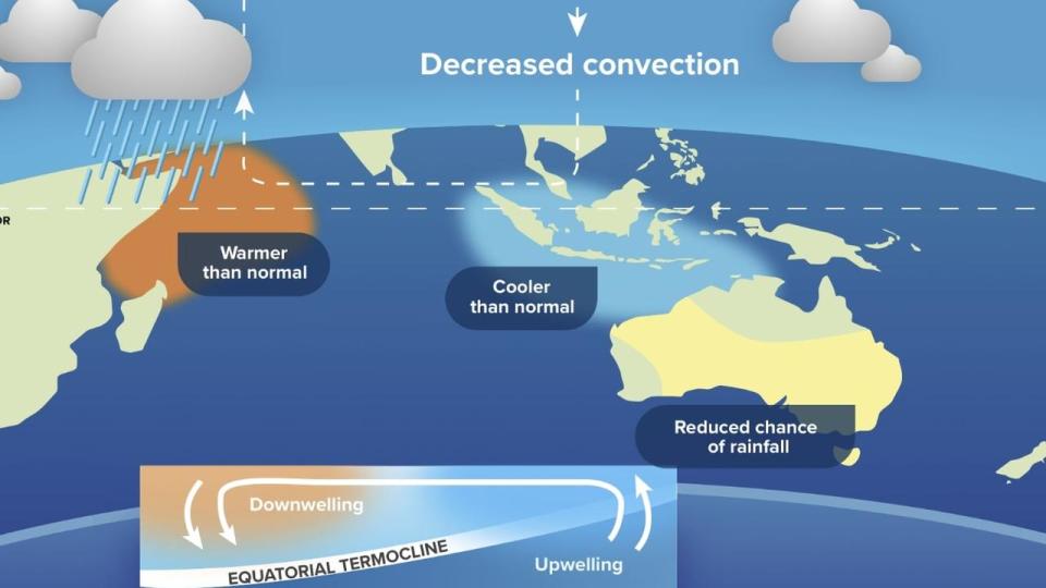
The alert from WeatherZone comes as meteorological organisations recorded a positive Indian Ocean Dipole that’s started to emerge off the coast of northwest Australia.
The Indian Ocean Dipole (IOD) refers to an index that measures sea surface temperatures in the tropical Indian Ocean.
“Positive IOD events reduce the amount of atmospheric moisture flowing towards Australia from the northwest, which typically suppresses rainfall and increases daytime temperatures over parts of the continent,” WeatherZone meteorologist Ben Domensino said.

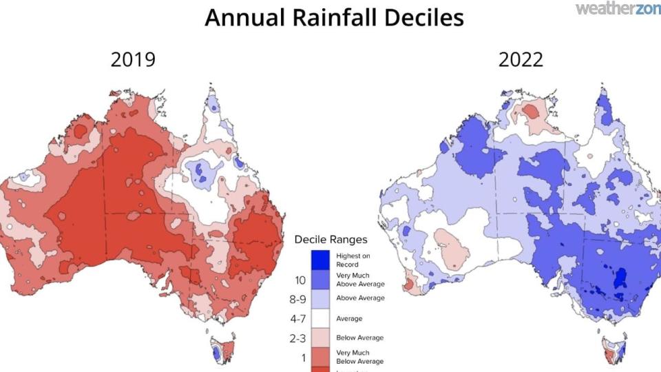
Australia last experienced a positive IOD event in 2019, which resulted in the nation’s driest year on record.
With a La Nina weather event taking place from 2020 to 2022, there is a strong change of conditions on the cards as parts of Australia continue to dry up.
“The IOD index has been in a neutral state (between -0.4 and 0.4) since October last year. However, the latest weekly value rose to 0.79, which is the highest value since December 2019,” Mr Domensino said.

The recent IOD results come just a day after the Australasian Fire Authorities Council released its seasonal bushfire outlook for spring 2023, with huge parts of Queensland, NSW and the Northern Territory under threat.
There is an increased risk of fire as north as Innisfail and Townsville and as far west as Winton in Queensland, while blazes can me seen over the majority of NSW north of Sydney and Wollongong.
The area at increased risk of fire has grown compared to 2022 due to increased vegetation from three years of La Nina aided by dry weather helping to add fuel loads to the landscape.

The developing positive IOD and a potential El Nino event are also adding to concerns that it will be a tough bushfire season
“Both of these climate drivers increase the likelihood that the second half of 2023 will be warmer and drier than average,” WeatherZone’s Anthony Sharwood said.
“The third factor (coming warmer-than-average weather) could make the summer bushfire outlook even more worrying.”

