
‘Severe’ storm warning after millions drenched

A week long weather pattern promising to drench as much as 90 per cent of the country by Sunday has dumped almost 100mm on Sydney in less than 12 hours.
The Bureau of Meteorology reported 94mm of rain at its Observatory Hill station since 9am on Monday, more than ten times all of the rain received in June last year.
The heavy rains sparked chaos across the city, flooding streets and scuttling much of Saturday’s Vivid events just a week into the annual light show.
New Sydney AquaDuck testing in the CBD this first day of winter pic.twitter.com/vo4Hvm1PVm
— Lord of the Dance (@trashyhonky) June 1, 2024
A severe thunderstorm warning was in place for much of the city’s coast on Saturday evening after a slow-moving storm was spotted near Bondi Beach and Watsons Bay.
The storm is forecast to affect Manly and Maroubra by 8.15pm, followed by Dee Why, Kernell, and Randwick by 8.45pm.
📍Pitt Street, Sydney #sydney#rain#weatherpic.twitter.com/0QfQkiTQaG
— Hayley Prenter (@PrenterHayley) June 1, 2024
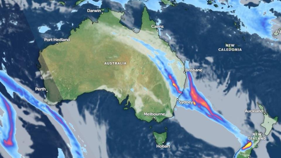
It comes as a cloud band continues to move east across the country, bringing with it the risk of more heavy rains.
Senior Meteorologist Sarah Scully said the rainband will continue to move along the east coast of Australia today.


“On Saturday, it will continue to track eastwards into southeastern parts of Queensland with patchy rain and showers continuing in eastern parts of NSW,” Ms Scully said.
“On Saturday night that low develops of the coast of NSW and as we move into Sunday it starts to track eastwards and really wrapping moist air into the coast there.”
By Saturday, northern NSW and parts of southern Queensland will get some of the predicted wet weather, with a forecast of 15-50mm expected.
The small reprieve from the first cloud band in Western Australia will be short lived, as a second rainband is predicted to develop over the state with signs showing it’ll hit the interior by Monday.
All together, it’s expected that at least 10mm of rain will fall onto two-thirds of Australia, on top of what’s already been felt this week.
NSW
Ms Scully said it would be “another wet weekend ahead for eastern parts of NSW”, but couldn’t say exactly where the worst of the weather would be.
“The heaviest rain and strongest winds are high dependent on the position, movement and proximity of the low to the coast,” she said.
“If the low remains slightly offshore then the coastal impacts will be limited during the period, however if it is expected to move closer to the coast the forecast may be upgraded to mention an East coast low.
“The low is expected to move south towards eastern Vic and the east coast of Tasmania early next week.”
Strong wind warnings have been put in place along the Byron Coast, Coffs Coast, Macquarie Coast, Hunter Coast, Sydney Coast, Illawarra Coast and Batemans Coast for Saturday.
Rain is expected to hit Sydney on Saturday, between 20 to 60mm and a maximum temperature of 19.

Tasmania
A minor flood warning at Corra Linn has been issued as a total rainfall of 20-70mm was recorded across the North Esk River within the last 24 hours.
The river at Corra Linn is currently at 1.95 meters and rising, resting just below the minor flood level.
The BOM is monitoring the situation closely.
Hobart will be partly cloudy with light winds, and a maximum temperature of 13.
Victoria
A minor flood warning continues to be issued for the Seven Creeks.
Melbourne is partly cloudy with a chance of morning fog within the nearby hills. Slight chance of a shower or two with a maximum temperature of 14.
Queensland
The marine wind warning for the Gold Coast waters is still in place, with a strong wind warning for South East Gulf of Carpentaria and North East Gulf of Carpentaria in place for Sunday.
In Brisbane it’s cloudy with a chance of fog developing in the west in the early morning. A high chance of 6 to 15mm of rain in the afternoon and evening, with a maximum temperature of 22.

Western Australia
A severe weather warning for heavy rainfall and a damaging destructive winds warning has been issued along the Central West to the South West coast. A cold front is set to bring severe weather to the West coast later on Saturday.
The BOM is warning that the heavy rainfall may lead to flash flooding along the South West district from late afternoon, with an expected 50 to 70mm of rainfall.
Damaging winds between 60 to 70km/h are possible along the South West district and is expected to spread to the Lower West and the Central West districts by Saturday afternoon.
The BOM is also warning residents of destructive winds peaking at 125km/h from late Saturday to early Sunday, which could cause significant damages to homes and properties.
Locations that could be affected are Bunbury, Busselton, Geraldton, Kalbarri, Mandurah, Manjimup, Margaret River and Perth.
Perth is mostly sunny with a high chance of showers along the southwest, with chances of thunderstorms in the west, with a maximum temperature of 23.
Australian Capital Territory
Canberra is partly cloudy with a chance of some areas developing frost in the early morning, along with some fog. Slight chance of showers and a maximum temperature of 15.

