
‘400mm of rain’: Cyclone lashes far north

Residents in the Gulf of Carpentaria are being warned of “significant hazards” as Tropical Cyclone Megan is set to develop into a category three cyclone on Sunday night.
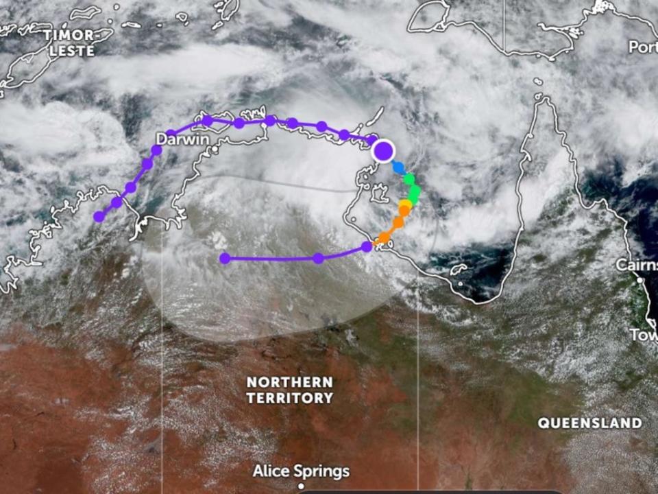
Tropical Cyclone Megan developed into a Category 2 cyclone overnight as the Northern Territory was lashed with “incredibly high rainfall”.
Flood warnings are in place, and the Bureau of Meteorology warns it will reach “severe” intensity on Sunday night.
“It’s continuing to intensify or will continue to intensify today as it moves down … we do expect it to reach severe cyclone intensity, so a category three system this evening,” senior meteorologist Miriam Bradbury said.

Ms Bradbury warned there was a “whole suite of very significant hazards” for communities in The Gulf of Carpentaria areas, as the Northern Territory recorded 400mm of rain in less than 24 hours.
It comes as the Northern Territory had 400mm of rain in less than 24 hours.
“These heavy forms do bring the risk of flash flooding and eventually riverine flooding as well. We’ve got flood watch as current for much of the Northern Territory and parts of Queensland too,” Ms Bradbury said.
Northern Territory and Queensland residents are also being warned “very destructive” wind gusts may be on the way, with gusts of 110km per hour being observed already.
“We may see very destructive wind gusts up to 200km per hour as it crosses the coast. Those wind strengths are incredibly strong,” Ms Bradbury said.
“They will cause damage, we have already had reports of damage about parts of the coast including Groote Eylandt.”
High tides are another area of concern.
“We’re expecting to see tides significantly above the highest astronomical tide, which is basically the highest high tide you can get,” Ms Bradbury said.
A coastal crossing is likely to occur on Monday or Tuesday morning.
“There’s sort of a cone of uncertainty, as we call it. Essentially there are still a number of possible solutions of how this could play out, but at this point, we are expecting the coastal crossing to occur at the west of the Northern Territory-Queensland border, “ Ms Bradbury said.
Current cyclone warnings span between Groote Eylandt in The Gulf of Carpentaria to the Northern Territory-Queensland border, extending to the border of Mornington Island.
It comes as the tropical low on the Gulf of Carpentaria reached a tropical one cyclone Saturday afternoon.

