
'Absolute pummelling': Pier ripped away as polar blast smashes southeast
A pier has broken away, buildings have been smashed by falling trees and widespread snowfalls are being reported as Australia’s southeast cops a battering from a severe burst of winter weather.
Ferocious winds reaching 120km/h swept through Victoria overnight and into NSW on Friday morning.
Victoria’s State Emergency Service had 157 calls for help across Victoria between 6am Thursday and 6am Friday, the majority for fallen trees and a few calls for building damage.
Melbourne's southeastern suburbs and Mornington Peninsula are getting the worst of the winds on Friday, according to the Bureau of Meteorology.
Winds reached 120km/h at Cape Otway in the state's west at about 5am on Friday.
With an almighty roar, the entire roof has just blown away at work in Silvan #storms #polarblast @vicemergency @7NewsMelbourne @9NewsMelb pic.twitter.com/y1lIZRiNUQ
— Kristin (@Kristin542) August 8, 2019
Winds are expected to ease in the Melbourne area from late morning when the rain is expected to hit the city.
A severe weather warning remains in place for the damaging winds for most of the state.
"A low pressure system tracking rapidly eastwards across Bass Strait will reach the Tasman Sea this morning," the warning reads.
Blizzard conditions are expected across alpine areas on Friday, with snow expected above 500m and flurries possible for the Dandenong Ranges.
BOM forecaster Beren Bradshaw told Yahoo News Australia, Macedon and Trentham can also expect snow flurries.
Snow at Macedon this morning. Slight risk of flurries in the #Dandenongs overnight, but better chance on Sunday. Some alpine roads closed, check @VicTraffic for updates. Snow forecasts on MetEye: https://t.co/9TUUJa3azB #VicWeather #VicSnow pic.twitter.com/Gncp3ngd8c
— Bureau of Meteorology, Victoria (@BOM_Vic) August 9, 2019
“Mount Hotham, Falls Creek and Buller can also expect a good amount of snow today,” she said.
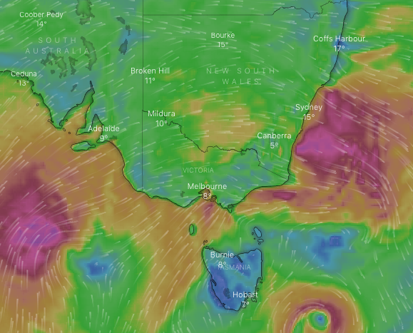
Icy temperatures are also set to continue across the state, with Melbourne headed for a top of 11 but strong winds will make it feel much colder.
On Twitter, residents tweeted about battling the wind and the rain on the way to work on the frigid Friday morning.
“Not sure if I'm going to blow away or wash away. Whichever, it'll be cold,” one man tweeted.
Another added “working in this weather is insanity”.
Mountain Watch reported Falls Creek receiving up to 60cm of snow.
Elsewhere across Victoria, Ballarat is forecast to reach just 7 and Mount Dandenong 4.
Corryong, near the NSW-Victoria state border, is forecast to hit a low of -2 on Saturday while Albury-Wodonga and Beechworth to the west will hit zero.
Batten down the hatches...Strong winds have brought down this massive pine tree outside the Victoria Hotel at Moonan Flat on the #Scone side of the #BarringtonTops.
The @BOM_NSW has issued a severe wind warning for much of the state today. Stay safe!
📸: Fiona Coddington pic.twitter.com/GRCVPuAA0O— Val Schaefer (@schaefer_val) August 8, 2019
Frankston pier breaks away
The pier at Frankston, southeast of Melbourne’s CBD, has been ripped apart due to the weather.
A resident tweeted video of the pier adding it had “snapped off and is floating away”.
Paul Edbrooke, the member for Frankston, also tweeted a photo of the smashed pier.
“The end of Frankston Pier has broken free and headed for the beach,” he tweeted.
The end of Frankston Pier has broken free and headed for the beach😳.
Thank you to all of our emergency services, and remember Call 132 500 from anywhere in Vic for flood, storm, landslide, tsunami and earthquake emergency. For life-threatening emergencies call Triple Zero (000). pic.twitter.com/jhvnpvpqfy— Paul Edbrooke MP (@paul4frankston) August 9, 2019
Department of Transport’s Chris Miller told 3AW radio “what's left of the pier is still copping an absolute pummelling at the moment”.
Tom, who works at Sofia Frankston cafe not far from the pier, told Yahoo News “waves just went straight over it”.
“It’s very, very windy,” he said.
By 9am, winds at Frankston were howling at 95km/h.
The end of Frankston Pier has snapped off and is floating away @3AW693 pic.twitter.com/OB49PjS8z6
— Chris R (@Chrissa) August 8, 2019
Winds batter NSW, snow falls in Canberra
In NSW winds of up to 90km/h are expected for the Southern Tablelands, Snowy Mountains, Illawarra, Southern Coastal Ranges and eastern parts of the Central Tablelands.
BOM meteorologist Craig Ryan told Yahoo News the worst is expected on Friday throughout the state.
“The winds will remain strong but not as strong over the weekend,” Mr Ryan said.
“Winds of 60-70km/h will hit the Sydney Metropolitan Area around mid-Friday morning.”
Those heading out for a weekend at the slopes are in for a high chance of snow showers.
Jindabyne has an 80 per cent chance of snow showers on Sunday with a max of 5 and -2.
Thredbo is likely to experience blizzards and possible small hail with a low of -7 on Saturday.
Snow will fall in Perisher Valley with chances of a thunderstorm in the afternoon and evening.
Good day folks ,
dusting of snow now ?
Check it out now people..#sujaysphotography #snowdust #actweather #liveweather #friday #canberra @WINNews_ACT pic.twitter.com/OUrRvrGkJG— Sujay’s Photography (@Sujaysphoto) August 8, 2019
The ACT has seen snow flurries on Friday morning with Canberra’s filming the white stuff coming down.
“There’s a possibility of some snow later today and overnight but it won’t be severe,” Mr Ryan said.
“It won’t be severe though - just some flurries for Canberra’s CBD and surrounding suburbs.”
Winds smash Adelaide
In South Australia, a warning was issued for damaging winds in Adelaide, Murray Bridge, Kingscote, Victor Harbor, Meningie and Coonalpyn.
The bureau predicted winds to average between 50-70km/h but they could also reach up to 90-110km/h.
Adelaide’s CBD is due for a top of 12 with showers. The rain will continue over the weekend but will ease with tops of 13 on Saturday and Sunday.
Adelaide, this weather is stressing me out! Stop with the wind! pic.twitter.com/qHyvSGOqq9
— Petra Starke 🌟🗝 (@petstarr) August 8, 2019
In Queensland, residents in the Granite Belt and Darling Downs are set to shiver through the weekend.
The region is headed for a low of 1 on Saturday before it plummets to -4 on Sunday.
It follows reports earlier this week a polar blast could bring snow flurries to the region.
Brisbane and the Sunshine Coast should be much warmer though with temperatures in the low 20s.
Flights cancelled in Melbourne
The powerful gusts have also led to a number of flight cancellations with more than 20 flights departing Melbourne for Sydney cancelled.
Sydney Airport also warned passengers to check with the airlines as the city “is set for a windy one” and some flights have already been cancelled.
With Paul Newman and AAP
Do you have a story tip? Email: newsroomau@yahoonews.com.
You can also follow us on Facebook, download the Yahoo News app from iTunesorGoogle Play and stay up to date with the latest news with Yahoo’s daily newsletter. Sign up here.
