
'Heavier rain to come': Towns under water as record storm lashes 1000km stretch of coast
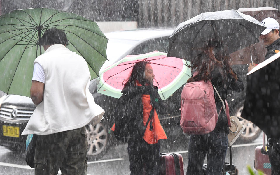
Heavy rain and strong wind continue to lash Australia’s east coast as rainfall records were smashed overnight, and people woke to find roads, homes and shopping centres under water.
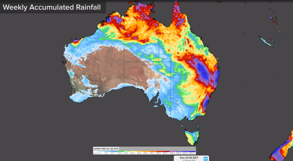
The hardest hit was Byron Bay on NSW’s far north coast, with Cape Byron receiving its biggest downpour in 46 years – 275mm fell between 9am Thursday and 9am Friday.
The SES attended 147 requests for help including rescuing backpackers who had misjudged the death of water, The Northern Star reported.
“We have had the big dry and horrendous bushfires, now we have flooding rain,” a resident of nearby Skinners Shoot said on Instagram on Friday morning.
“Going to the shop in Byron Bay now requires a wetsuit”, one person wrote with video of flooded Byron Bay shops.
There were several other NSW North Coast towns hit with rain in quantities over 100m for the 24 hour period, including 179mm in Ballina and 111mm in Grafton.
“Ballina had its wettest day since 2016, and for a February day that goes back to 2001,” Weatherzone’s Craig McIntosh told Yahoo News Australia.

The worst to come for Sydney
Sydney also copped a drenching. Manly on Sydney’s Northern Beaches recorded 104mm, the highest for the city, while nearly 80mm was recorded in the city and closer to 90mm on the North Shore.
More than 300mm of rain will fall in parts from Friday into the weekend.
“The trough is deepening and moving south along the coast, so over the weekend much of the heavier rain will also push south along the coast,” Mr McIntosh said.
“Sydney’s wettest days could be over the weekend and could be more than what we’re going to see today (Friday).”
Drought and bushfire ravaged regions of NSW and southern Queensland also received much-needed rain. NSW Rural Fire Service Commissioner Shane Fitzsimmons took to Twitter to celebrate the heavy rain falling.
“Falls across our fire areas will be so welcomed by our farmers, fire fighters & all affected,” he said.
'Heaviest rain in years': Massive deluge to hit Australia's east coast
Heavy downpour to pummel east coast with a month's worth of rain in one week
Bushfire-ravaged east coast set for drenching as 'monsoonal trough' lingers
A severe weather warning for heavy rain and damaging wind is expected to remain in place throughout the weekend. It covers a coastal region stretching for over 1000km from the Queensland border to the NSW south coast.
Streets have been flooded in Byron Bay after 281mm of rain fell this morning, as parts of NSW are set to receive their “heaviest rain in years.” #SydneyRain Full Story: https://t.co/S53KMLnQSC pic.twitter.com/Z4u6lIgC8h
— Yahoo News Australia (@YahooNewsAU) February 6, 2020
Flash flooding warnings remain for NSW and Queensland
Flash flooding and heavy rain will affect people in the NSW Mid North Coast, Sydney Metropolitan, Illawarra and parts of Northern Rivers, Hunter, Central Tablelands and Northern Tablelands Forecast Districts.
“The weather warning that’s out for eastern NSW now will probably stay for at least the next two to three days”, Mr McIntosh said.
Melbourne will avoid much of the heavy rain but could experience some significant downpours early into next week, he added.
Queensland’s southeast will have heavy rain over the coming days and the flood warnings are likely to stay active throughout the weekend.
The Courier Mail reported Friday morning that major roads including Gympie Rd at Carseldine and the M1 Bruce Highway at Griffin had flooded due to the heavy rain.
More than 180mm fell in Maryborough on the Fraser Coast in the 24 hours up until Friday morning and parts of the Mary River spilled over at the seams.
So nice listening to rain falling last night & driving with windscreen wipers on for a change this morning. @BOM_NSW indicates continued rain this next week & importantly, falls across our fire areas which will be so welcomed by our farmers, fire fighters & all affected. #NSWRFS pic.twitter.com/gJ3aFRQlzF
— Shane Fitzsimmons (@RFSCommissioner) February 6, 2020
Cyclone Damien to intensify near WA’s Pilbara coast
The Weatherzone forecaster said there could be even more wild weather in store in the coming days for Queensland, as indications suggest a tropical cyclone is forming over the Coral Sea.
On the other side of the country Cyclone Damien is heading towards Western Australia’s Pilbara coast and is expected to intensify on Friday.
Residents between Dampier and Pardoo Roadhouse, including Dampier, Karratha and Port Hedland, are warned of the potential of a very dangerous storm tide as the cyclone crosses the coast.
Damien was classified as Category 2 with sustained winds of 100 kilometres per hour and wind gusts to 140 kilometres per hour.
Do you have a story tip? Email: newsroomau@yahoonews.com.
You can also follow us on Facebook, Instagram and Twitter and download the Yahoo News app from the App Store or Google Play.


