
'Heaviest rain in years': Massive deluge to hit Australia's east coast

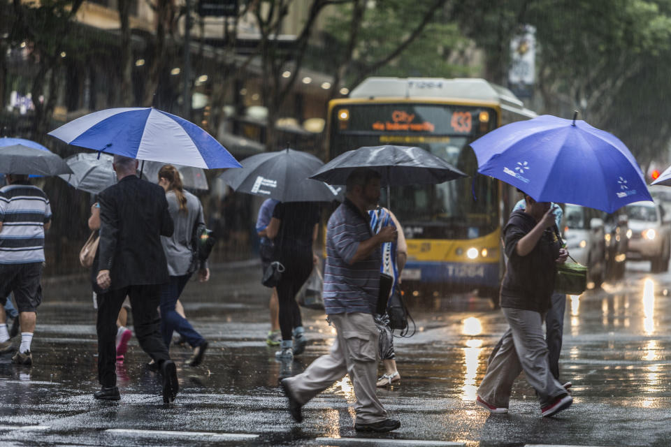
Parts of southeast Queensland have been drenched and flood warnings are in place as other states brace for a massive deluge of rain.
Sky News Weather Chief Meteorologist Tom Saunders told news.com.au parts of Queensland and NSW are in for the “heaviest rain in years”.
“This major weather event will continue into the weekend,” he told the publication.
Brisbane Airport has received 38mm since 9am Thursday while Redcliffe, north of the CBD, has received 25.
Communities near Tin Can Bay, in the Wide Bay-Burnett region, recorded falls of more than 200mm in the 24 hours to 9am on Thursday.
It's been raining in Brisbane 🌧🌈
So I rugged up and went out for a lovely little walk ✨ pic.twitter.com/6VRDTAlLXM— 🎀Sammy🎀 @ Brissie ☀️ (@SammyTeaTime) February 6, 2020
Coops Corner, in the same area, recorded a whopping 260mm in the same time, taking its weekly total to 390mm.
Many coastal locations recorded between 50 and 100mm in just a few hours.
Heavy rain drenched the region between Hervey Bay and the New South Wales border on Wednesday night and Thursday morning.
Brisbane experienced commuter chaos as water covered some major arterial roads.
The low-pressure system has pushed south into northern NSW, but forecasters say more rain is on its way.
Bureau of Meteorology forecaster Kimba Wong said drought-stricken areas of southern Queensland are expected to get the best of the rain on Sunday, before the weather system moves towards the coast.
"We should see some pretty good rainfall totals for drought-stricken areas through the eastern parts of the Maranoa and Warrego and through the Western Downs," Ms Wong said.
A flood watch is current for coastal communities south of Caboolture to the NSW border, and southern inland catchments.
"Catchments in the flood watch area have received rainfall over the last few weeks so will respond to heavy rainfall," the bureau has warned.
Proper rain for the last 24 hours. The ground is getting a wonderful soaking. Though it usually means the internet stops working. #Brisbane #SouthEastQld pic.twitter.com/PzB2vp7WCc
— Leesa Watego (@leesawatego) February 6, 2020
Catchments likely to be affected include the Pine and Caboolture rivers, the upper and lower Brisbane River, the Logan and Albert rivers, and Gold Coast rivers and creeks.
Inland river systems are also under flood watches or warnings.
Brisbane Airport is forecast for between 35 to 60mm on Friday. Similar totals are also predicted for areas on the Sunshine Coast while the Gold Coast could be drenched with up to 80mm.
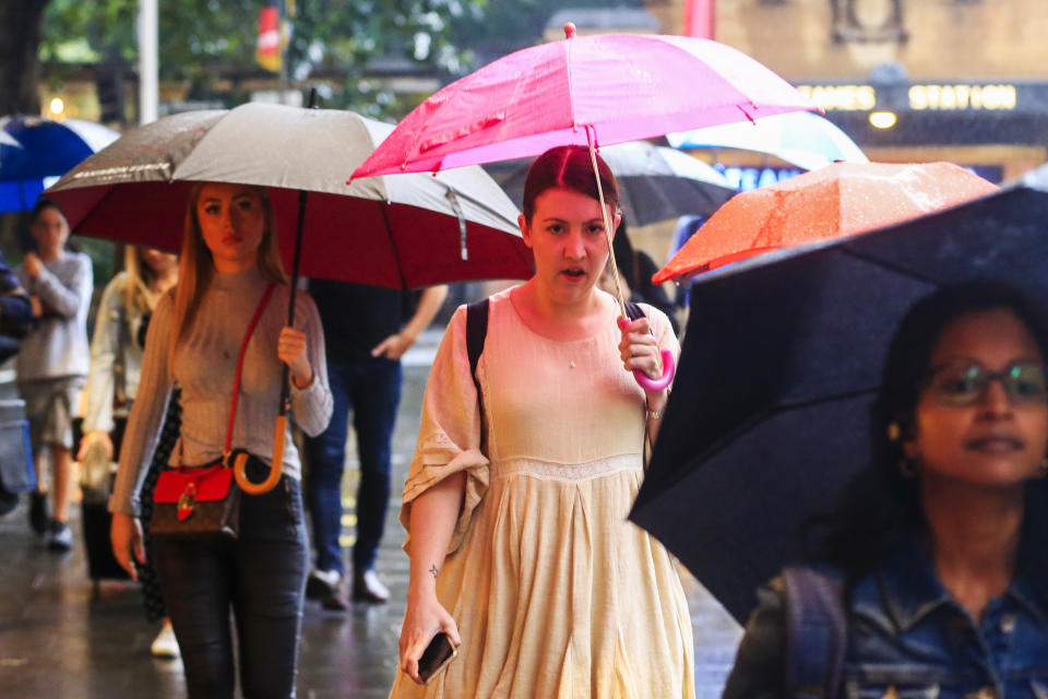
Wet weekend forecast for Sydney
Anyone heading to work in Sydney’s CBD on Friday morning is going to need an umbrella with between 45 and 90mm forecast for Friday.
These conditions should continue through to Saturday and Sunday, making for a wet weekend.
BoM has issued a warning for heavy rainfall, which may lead to flash flooding for parts of the Northern Rivers, Mid North Coast and eastern parts of the Northern Tablelands forecast districts from Thursday.
From Friday, northern parts of the Hunter may be impacted too, BoM said.
Coffs Harbour on the NSW Central Coast could receive up to 200mm on Friday, however it should ease on Saturday to between six and 20mm before its kicks off again on Sunday with a possible total of 120mm.
Newcastle is also in for heavy rainfall with possible totals of 60mm on Friday and Saturday, and 70 on Sunday.
The South Coast won’t escape the deluge either with 80mm forecast for Friday in Kiama, and up to 200mm forecast for Saturday. Up to 150mm is predicted for Sunday.

Cyclone could hit WA
Residents in Western Australia's Pilbara region are being urged to prepare for destructive winds and possible flooding as a result of a severe tropical cyclone.
A tropical low off the Kimberley was expected to develop on Thursday into Tropical Cyclone Damien, the state's third tropical cyclone for the year.
The Bureau of Meteorology expects it to reach the Pilbara coast between Port Hedland and Onslow on Saturday as a severe tropical cyclone.
Destructive winds with gusts up to 150km/h may develop on Friday night, increasing further on Saturday near the cyclone centre.
Abnormally high tides could also cause serious flooding at the coast between Dampier and Wallal.
Tropical Cyclone Damien is forecast to develop further and turn towards the Pilbara coast on Friday. Gales are expected on the Pilbara coast later on Friday ahead of a severe cyclone impact on Saturday. #CycloneDamien https://t.co/B1MVXBYXhh pic.twitter.com/tecljy5NMn
— Bureau of Meteorology, Western Australia (@BOM_WA) February 6, 2020
Rainfall totals may exceed 300mm close to the cyclone path, the bureau says.
Residents of towns in the Pilbara between Port Hedland and Mardie, including Karratha and Dampier, are being encouraged to organise emergency supplies such as a first-aid kit, torch, portable radio, spare batteries, food and water.
Both Port Hedland and Karratha are home to significant mining and oil and gas and operations.
The bureau is also warning that much of southern WA will experience elevated fire danger for the rest of the week as a result of hot and windy conditions.
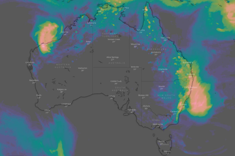
Perth on Tuesday recorded its hottest day in five years and hottest February day since 1997, with the mercury hitting 42.7C.
The temperature was forecast to reach 31 on Thursday, while a possible thunderstorm is forecast for Friday.
With AAP
Do you have a story tip? Email: newsroomau@yahoonews.com.
You can also follow us on Facebook, Instagram and Twitter and download the Yahoo News app from the App Store or Google Play.


