
Peak-hour commuters warned to brace for hail and 90km/h winds
Peak-hour commuters across Sydney are being warned to brace for more wild weather for their trip home including damaging winds, thunderstorms and likely hail.
The Bureau of Meteorology issued a severe thunderstorm warning late on Wednesday afternoon with heavy rainfall and strong winds to hammer the city over several hours.
Newcastle, Gosford, Maitland Penrith and Parramatta are also predicted to be heavily hit.
“Severe thunderstorms may produce heavy rainfall that may lead to flash flooding, and damaging winds,” the warning read.
Sydney trains have said there are delays on the T2 and T3 lines, while all other passengers should expect delays due to the weather conditions, urging commuters to allow extra travel time.
Due to severe weather conditions, services are currently experiencing delays.
Please allow extra travel time. Stopping patterns may change at short notice.
Updates to follow. pic.twitter.com/ngtwWBEuBt
— T3 Sydney Trains (@T3SydneyTrains) November 28, 2018
On Wednesday morning 120mm of rain drenched Sydney’s CBD, smashing the November average monthly rainfall of 84mm.
In the early afternoon Sydneysiders had a brief respite, but forecasters warned of another “severe” thunderstorm to bring heavy rainfall and “large hailstones”.
Strong winds have also been predicted to hit the city with 60km/h to 70km/h wind gusts predicted. Gusts could reach up to 90km/h in the Illawarra area.
Authorities have urged people to consider alternatives for the afternoon commute or school pick-up.
Crazy weather this morning and my house is flooding. #sydneystorm #nothappyjan
A post shared by Shane Pascoe (@shanejoycepascoe) on Nov 27, 2018 at 1:14pm PST
On Wednesday, Mosman recorded 123mm of rain while Chatswood had 119mm, including 66mm within one hour. Shoalhaven’s Porters Creek Dam has recorded the state’s highest total so far, copping 168mm on Wednesday morning.
Police are encouraging people at home to stay indoors.
“If you stayed at home today, stay at home the rest of the day, but, please, don’t go out this afternoon because it is predicted to come back and get worse this afternoon,” NSW Police’s highway patrol chief Michael Corboy said.
“The conditions we are experiencing today are some of the worst I’ve ever seen, and I am appealing to everyone, motorists and pedestrians alike, to take care.”
Meteorologist at the Bureau of Meteorology, Elli Blandford, told Yahoo News there was a chance thunderstorms developing in the Hunter region around lunch time could hit the city in hours, affecting the afternoon commute.
The second phase of this rain event is now beginning to spin up over parts of #NSW. Storms & intense rain are are starting to return to areas incl #Sydney #Newcastle & #Wollongong. This system has already proved to be dangerous so commuters check warnings https://t.co/Ayc0ffpmyI pic.twitter.com/OjYyHPwtYY
— Bureau of Meteorology, New South Wales (@BOM_NSW) November 28, 2018
trying to get to work #storm #sydneystorm #sydney
A post shared by Drew Unsworth (@rustythescamp) on Nov 27, 2018 at 12:29pm PST
Afternoon peak-hour commutes to be impacted
Transport for NSW coordinator general Marg Prendergast advised commuters to allow extra time travelling home this afternoon.
“If possible, leave work early to avoid the peak,” she said in a statement.
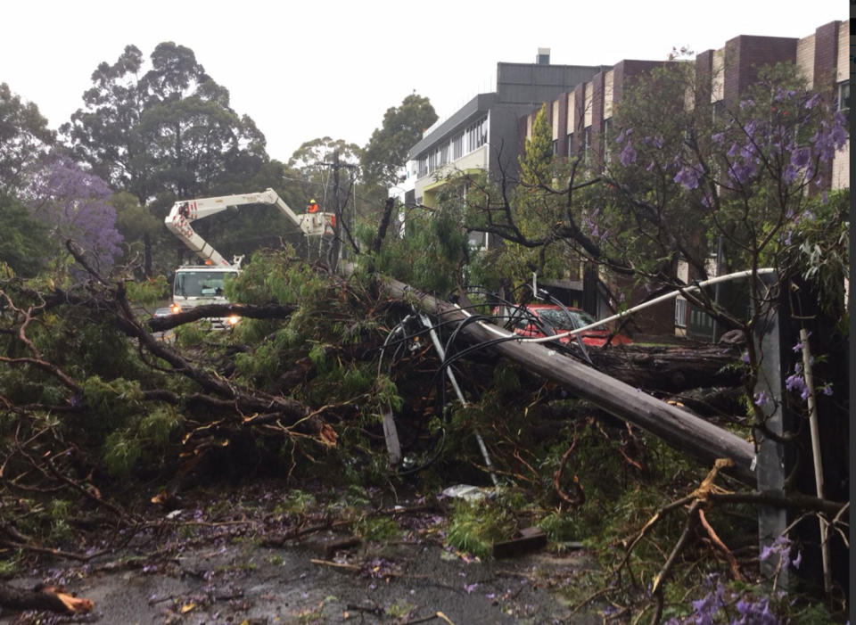
“Strong winds are causing fallen trees and branches to impact roads and public transport across Sydney.”
Lewisham Station in the inner west reopened after being closed early on Wednesday due to flooding but there will be some delays to train services across the network due to severe weather.
Ms Prendergast said commuters should listen to station announcements and check indicator boards.
Emergency buses will also be on standby this afternoon in the event of flooding or other impacts to the rail network.
I was just caught driving in a hail storm and it was bloody scary! I'm too scared to see if there's any damage to the car! pic.twitter.com/OC14wt28MQ
— Ellen Briggs (@ellen_briggs) November 28, 2018
The rain really hitting hard in Sydney’s North @7NewsSydney pic.twitter.com/399cpniNvD
— Peter Fegan (@PeterFegan7) November 27, 2018
Buses will replace Parramatta River ferries between Parramatta and Sydney Olympic Park. The Cockatoo Island Wharf is also closed and F3 and F8 ferries will not stop there.
Buses will replace the light rail between Central and Dulwich Hill due to flooding and commuters travelling by bus should expect a number of delays.
“If you’re driving, remember to never drive through floodwaters, slow down, leave plenty of space between you and the car in front and drive to the conditions,” Ms Prendergast said.
Sydney Airport repeatedly closed one of its runways during the morning as it tried to operate amid strong winds.
About 130 domestic flights and four international flights have been cancelled due to the weather.
Taronga Zoo also said on Twitter it would close at 2pm due to lightning and storms.
Guests on the grounds during the closure were offered complimentary passes by staff to return another day.
Roar and Snore has also been cancelled this evening.
New water feature at my local train station. Looks great 😂 #SydneyWeather #Sydney #SydneyStorm
A post shared by @ brypix on Nov 27, 2018 at 2:24pm PST
Widespread flooding in Sydney expected
A low pressure system and associated front moved into central NSW on Tuesday and deepened near the coast on Wednesday.
BoM said minor to moderate flooding may develop along the Hawkesbury Nepean River and Georges River.
Widespread areas across Sydney Metropolitan experienced localised flooding on Wednesday morning.
Minor flooding is expected along the Cooks River at Tempe in Sydney’s inner west.
BoM’s chief hydrologist for NSW/ACT, Justin Robertson, said while a minor flood warning is out for the Cooks River and other rivers were on flood watch, minor streams and urban environments could suffer flash flooding.
“It’s still early days and it’s a dynamic situation,” he told reporters.
The SES has responded to nearly 1000 calls on Wednesday with most due to storm damage and fallen trees.

An SES spokesman told AAP their major concern was people driving into floodwaters, putting their lives and the lives of volunteers at risk.
Roseville Bridge and dozens of roads across the city were shut due to flash flooding while a landslide on Spit Road in Mosman also caused issues.
More than 10,000 properties lost power across the city, including the CBD and northern suburbs, with lightning strikes and strong winds damaging lines.
AusGrid said the torrential downpour flooded an underground substation at Wynyard.
Frustrated emergency services urged NSW drivers to slow down or avoid all non-essential travel in the afternoon.
One police officer broke her leg when a tree fell on her police car as she and her partner were at North Ryde where drivers had unsuccessfully tried to get through a flooded road about 6.45am.
Later, one man died in a two-car collision in Thornleigh in wet conditions.
NSW Ambulance Acting Superintendent Steve Vaughan said paramedics attended four times the normal amount of car crashes on Wednesday.
“Everyone has somewhere to be but … if there is floodwater across the road, please stay out of it,” he told reporters.
A severe thunderstorm warning for heavy rainfall, damaging winds and large hailstones is still current for the Sydney metro, the Hunter and the Illawarra regions and parts of the Mid North Coast, South Coast, Central Tablelands, Southern Tablelands, North West Slopes and Plains and Northern Tablelands.
Wild weather to ease on Thursday
Ms Blandford said Sydney would experience light showers on Thursday morning but they would ease by the afternoon and Friday.
“Over the next couple of days the system won’t impact us,” she told Yahoo News.
“It is forming throughout today and will move away from the coast this evening and tomorrow morning.
“There will be remnants of shower activity in the morning but it will move away by Thursday afternoon.”

