
Firefighters brace for mid-week heatwave set to exacerbate bushfire danger
Firefighters are bracing for a mid-week heatwave that will increase the fire danger as they continue to battle out-of-control blazes on the east coast.
The Bureau of Meteorology is predicting parts of Australia will experience heatwave conditions.
“Pretty much the entire country is going to see above average temperatures over the next week,” a Bureau of Meteorology (BoM) spokesperson told Yahoo News Australia, who said the real focus would be on the southern part of Australia.
According to BoM from Monday to December 1, temperatures are likely to be above average across most of Australia, but southern Victoria and Tasmania were forecast to be cooler than average.
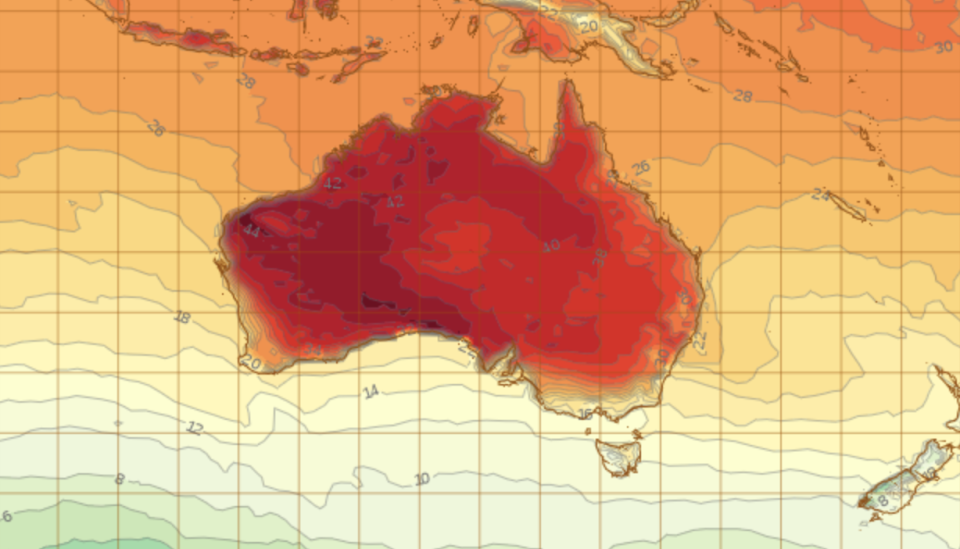
Meanwhile most of NSW will be engulfed in either a low-intensity or a severe heatwave by Tuesday, despite a cooler southerly breeze moving up the east coast on Sunday.
“We will see the heat passing through NSW again on Tuesday and a little bit of a break on Wednesday and on Thursday the heat is back,” the BoM spokesperson told Yahoo News Australia, adding most of the state would experience warm conditions until next weekend.
Sydney is expected to reach a high of 32C on Tuesday and Thursday is predicted to top 29C.
Fire danger warnings in northern NSW and Sydney increased on Sunday, with four northern NSW regions rated as severe, and very high in the Greater Sydney, Greater Hunter, Central Ranges and North Coast regions.
Hawkesbury Mayor Barry Calvert said people have done all they can and now face an anxious "sit and wait" situation.
"People are waiting for this week to be over I think," he told AAP.
Severe #Heatwave forecast for second half of the week over #NSW ranges, slopes, #CentralWest and the #ACT https://t.co/fbf9FOOKTM Have a plan to #BeatTheHeat pic.twitter.com/f4C1oR6voz
— Bureau of Meteorology, New South Wales (@BOM_NSW) November 16, 2019
"We have two or three days this week that are going to be 38C to 40C and strong winds.
"I think they've done everything they can do and it's just now a matter of holding (the fire) back if they can. People are just walking around hoping for the best. There's not a lot more that can be done."
Conditions will ease in the south-west come Wednesday, but more of the state will be affected by a severe heatwave.
“Any kind of increase in heat can elevate fire dangers,” the BoM spokesperson said.
There will be an increase in fire danger on Tuesday and Wednesday.
From the west coast of Cape York Peninsula to the inland and southeastern parts of Queensland, a low intensity heatwave can be expected throughout the week, according to BoM.
Fire dangers will increase as temperatures rise on Wednesday throughout central and Southern Queensland.
Brisbane will reach a high of 30 on Tuesday and continue to endure temperatures in the high 20s for the rest of the week.
Perth’s record hot day
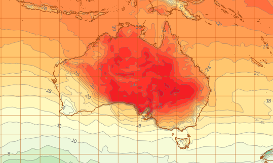
According to BoM, the heat will shift across to the east as the week progresses, but will build up across South Australia before the heatwave is felt in the east.
Perth reached 40.4C on Saturday, making it the hottest November day on record.
While Perth is only expected to reach a top of 28 degrees on Sunday, the mercury will creep back up to 31 on Monday before dropping to the low 20s until Friday.
Kalgoorlie is expected to reach temperatures as high as 44C on Sunday and have the heat linger until Wednesday when temperatures will drop to a high of 26 and a low of 11.
Most regions of Western Australia have high fire danger ratings on Sunday, four regions experiencing “catastrophic” fire dangers on Sunday - East Pilbara Coast, East Pilbara Inland, Ashburton Inland and North Interior.
The heat from Western Australia will gradually move east over the coming week.

Heatwave will move east
BoM says Wednesday is going to be the hottest day for South Australia, with a top of 42 degrees in Adelaide, with some of the heat extending to parts of Victoria on Wednesday.
Through South Australia on Wednesday, the cold front will bring strong northerly winds, which will be “very dry, very hot”, which will exacerbate fire dangers.
While the heat will be mainly in the southern part of Australia, it will still get quite warm in northern parts of Australia, notably in Broome, Western Australia and the top half of the Northern Territory.
The BoM spokesperson said come Thursday the heat would continue to move further east, and will start to affect parts of Victoria and NSW, with the heat continuing to hang around in NSW on Friday.
“It really is just a rolling pattern of heat over the next week or so, across all of Australia,” the BoM spokesperson said.
What to do during a heatwave
Heatwaves are categorised by uncomfortably hot weather for a period of three or more days.
NSW Health lists three main things to keep healthy during a heatwave – drink plenty of water, keep cool, take care of others and have a plan.
When the temperature is five degrees above average in an area for more than five days, people are more at risk of suffering heat-related illnesses.
The early signs of heat stress include rising body temperature, dry mouth and eyes, headache, shortness of breath, vomiting and lack of tears when crying, according to Queensland Health.
Some people are more prone than other to falling ill during a heatwave, older people, babies, young children and people who are on medications.
Do you have a story tip? Email: newsroomau@yahoonews.com.
You can also follow us on Facebook and Twitter, download the Yahoo News app from the App Store or Google Play and stay up to date with the latest news with Yahoo’s daily newsletter. Sign up here.

