
New heat map reveals location of active coronavirus cases

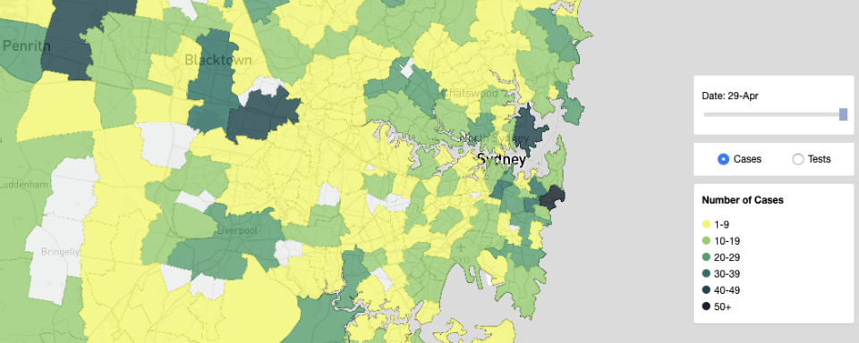
The NSW government has rolled out ‘Australian-first’ heat maps that allow people to check how many active cases of coronavirus are in their postcode as restrictions begin to ease from Friday.
Premier Gladys Berejiklian announced the “important” new feature on Friday morning which can be found on the state government’s website and will allow residents to work out if they are among a hotspot and to come forward and get tested.
“This will provide important data on where the cases are, how many people have been tested in those areas but also give a good picture to people who might live in a hot spot to make sure they're extra cautious and come forward and get tested,” she told reporters.
“We appreciate they are an important tool and source of information for people as we go through this process, and as we are easing restrictions it is so important for us to keep the number of tests up but to also make sure people are aware of what's happening in their own communities as they move around their own communities.”
One map also shows the number of tests carried out in each suburb.
As restrictions are eased on Friday, allowing two adults and their dependent children visit another household, Ms Berejiklian believes there will inevitably be a rise in cases and community transmission moving forward.

On Friday, NSW Chief Medical Officer Dr Kerry Chant revealed there were nine new cases from Thursday, at least four of those from community transmission.
The new heat maps are a valuable tool in supporting Scott Morrison’s three musts of ramped up testing, improved contact tracing and more efficient responses to outbreaks that need to be met in order to ensure a smooth journey out of restrictions.
RELATED: Interactive coronavirus maps for the rest of Australia
The app will likely prompt more testing and minimise the threat of any new clusters arising by providing up to date data to residents, the state government believes.
NSW has targeted 8,000 tests daily, recording 7,038 on Thursday.

The new map shows postcode 2787, which covers Caddens, Cambridge Gardens and Cambridge park, has the most active cases in the state.
Thirty-one of its 46 cases are still active, and is home to the troubled aged-care facility Newmarch House which has been the centre of a cluster in Sydney’s west, and where 13 people have died.
Other notable postcodes include neighbouring 2750 with 12 active cases, 2170 which incorporates Casula with nine, Northern Beaches postcode 2099 including Dee Why with seven, and Mosman also with seven.
The former biggest hotspot in Australia, Bondi, now only has two active cases.
In regards to tests, the Bondi, Casula and Penrith areas all have the highest testing, all with over 2000 tests so far.
Do you have a story tip? Email: newsroomau@yahoonews.com.
You can also follow us on Facebook, Instagram and Twitter and download the Yahoo News app from the App Store or Google Play.


