
More rain to fall across eastern states following 'one-in-100-year event'
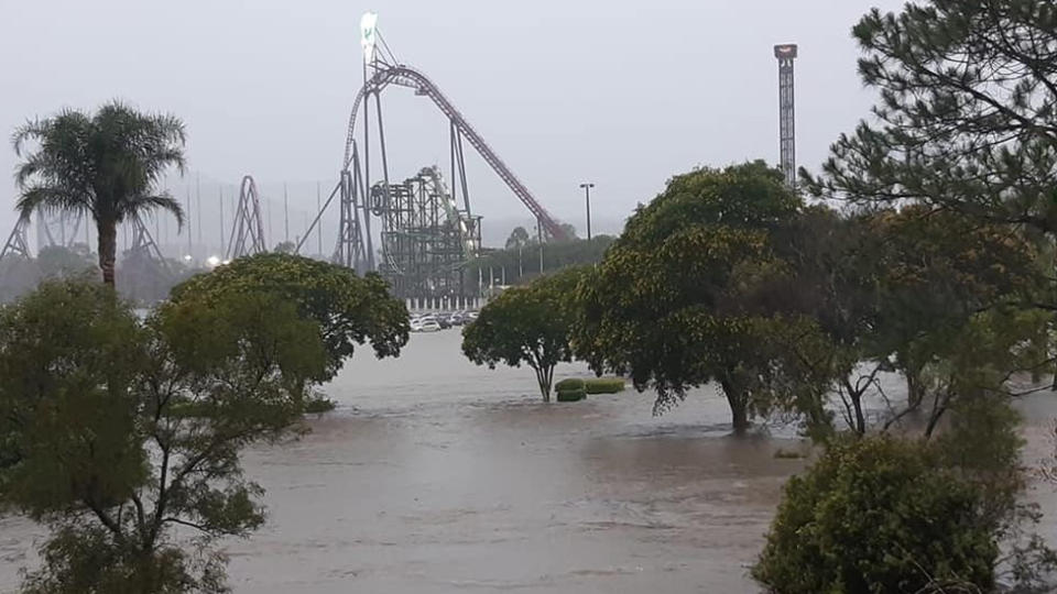
Southeast Queensland is bracing for more storms after torrential rain swamped the region causing flash flooding that closed roads and theme parks on Saturday.
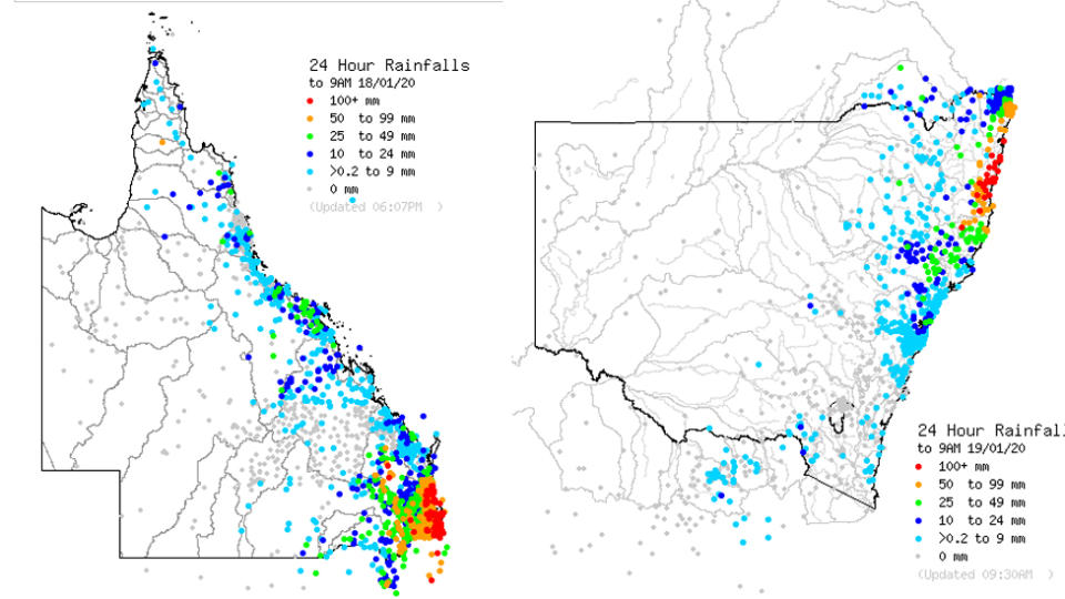
The deluge hit the Gold Coast the hardest with 325mm of rain falling at Loders Creek and more than 200mm in the Gold Coast Hinterland.
According to the weather bureau, triple the monthly rainfall has fallen on the Gold Coast in just 12 hours.
More moderate showers and storms are forecast for the region for Sunday with falls of up to 15mm predicted.
"There is an 80 per cent chance of more storms and shower activity, but nothing to the extent that we have seen overnight," a BoM spokesman said.
Due to flash flooding in parts of the state, Queensland Fire & Rescue warned parents on Sunday to make sure their kids understood the danger of playing in stormwater pipes and drains, saying it was a “dangerous mix”.
❌Kids + stormwater drains = a dangerous mix ❌
Parts of the state have recently experienced some flash flooding and with more rain forecast, it’s a timely reminder for parents to chat to your kids about water safety and the dangers of stormwater pipes and drains. pic.twitter.com/vI85gPIpaf— Qld Fire & Emergency (@QldFES) January 18, 2020
Flashfloods cut the M1 Motorway at Helensvale for almost seven hours on Saturday as debris blocked the drains and emergency workers struggled to pump the water clear.
Thousands were trapped in traffic gridlock before the M1 finally reopened just after 1pm.
On the southern end of the Gold Coast, two people were injured when a tree fell on their car on Currumbin Creek Rd during the downpour.
Flooding forced theme parks - Warner Bros Movie World, Dreamworld and Whitewater World Theme Park to close but the parks are expected to reopen on Sunday.
Bureau of Meteorology forecaster Kimba Wong described the thunderstorms as a “one-in-100-year event”.
Storms en route as Victorian fires burn on
Storms expected to lash parts of central and eastern Victoria on Sunday could bring some good news for firefighting efforts, as more than a dozen blazes continue burning in the state.
But heavy rainfall could also bring challenges for fire-ravaged regions, namely the risk of debris washing into waterways and landslides.
There were 16 fires burning in Victoria late on Saturday, predominantly in the East Gippsland and the northeastern alpine regions.
A blaze was also burning out-of-control on French Island at Western Port in southern Victoria.
An emergency warning - the highest alert level - had been issued about 4:30pm for the fire at the island's Ridge Track, before being downgraded to advice level about six hours later.
"You should continue to stay informed and monitor conditions," the advice warning read.
Authorities earlier downgraded emergency warnings in Victoria's alpine region despite difficult fire conditions overnight.
Thunderstorms possible today statewide. Severe thunderstorms with heavy rainfall are likely across parts of central and eastern #Victoria, large hail and damaging winds are also a possibility.
Any warnings can be found at:https://t.co/B1HPK0oi71 pic.twitter.com/61LGi4czTX— Bureau of Meteorology, Victoria (@BOM_Vic) January 18, 2020
Storms are expected to develop in Victoria on Sunday afternoon, particularly in the central and eastern regions, as a low pressure trough moves across from NSW.
They will bring rain, high moisture levels and thunder to some fire areas, particularly the alpine region.
Bureau of Meteorology senior forecaster Michael Efron said that is good news in one sense for fire-ravaged landscapes, but may be troublesome in another.
"Rainfall runoff can actually contain a lot of debris and that could get washed into waterways and across roads as well, so at the same time increasing the risk of landslides," he told AAP.
"There's good and bad associated with this activity."
Rainfall totals of about 5mm to 10mm are expected, but some areas could have totals of up to 50mm.
"It does look like that rain could be intense, in some parts of the state at least," Mr Efron said.
Rain set to continue in parts of NSW
Rain is expected to continue lashing parts of drought-stricken NSW.
The state's northeast and Northern Rivers regions are tipped to receive further showers on Sunday, as a system that has caused bucketing rain and flash flooding in Queensland moves south.
Bureau of Meteorology forecaster Abrar Shabren said on Saturday afternoon the effect would be felt for at least another day in the northeast and Northern Rivers areas.
"The rainfall will continue for the next 24 hours and substantial rain is expected at those locations," he said.
The Tweed and Northern Rivers regions have so far copped the state's biggest falls, with Clothiers Creek receiving 250mm in the 24 hours to 9am on Saturday.
On the mid north coast, Grafton had 155mm of rain and Killabakh had 112mm.
Keep that rain dance going! 🌧 - Pic: Robertson RFS. #nswrfs #nswfires pic.twitter.com/B5f66kclkt
— NSW RFS (@NSWRFS) January 16, 2020
Downpours over the last several days have provided relief for a state ravaged by bushfires, with the number of blazes in NSW dropping from 111 to 73 in six days.
However, there are concerns heavy rain could lead to flash flooding and landslips in parts of southeast NSW and the south coast as the weather system moves towards Victoria over the next 24 hours.
Do you have a story tip? Email: newsroomau@yahoonews.com.
You can also follow us on Facebook, Instagram and Twitter and download the Yahoo News app from the App Store or Google Play.

