
More heavy rains, huge waves and flooding set for east coast after 'mind-blowing' deluge

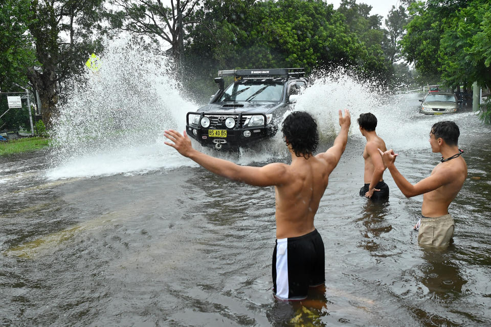
Australia’s east coast has been absolutely battered with rain in recent days causing flash flooding in parts of Queensland and NSW – but it’s far from over.
With more rain on the way for the eastern seaboard, things could turn ugly if a swirling mass of air in the Pacific which has grown strong enough to be dubbed Cyclone Uesi decides to move south and near Australia’s east coast.
A severe weather warning was issued Monday for the NSW mid north coast and northern tablelands as well as the greater Newcastle region, the central coast, and Illawarra and south coast areas, with the Bureau of Meteorology warning about hazardous surf conditions up and down the coast.
As of Monday afternoon, there were 17 flood warnings in place across the state with intermittent rain expected.
A strong chance of rain is forecast for Sydney and the central coast on Tuesday with thunderstorms likely returning on Wednesday.
“Over the last few days we saw a coastal trough cause very large rainfall down the east coast of Australia with widespread falls of 100 to 300 millimetres from the Sunshine Coast in Queensland all the way down to the central coast of NSW,” Bureau of Meteorologist Grace Legge said.
The trough will begin to ease by Wednesday “with a pattern of rain and thunderstorms returning to the east coast,” she said.
Rain is forecast to fall throughout the week which could hamper clean up efforts after Sydney and surrounding regions but forecasters aren’t expecting the rain to be anywhere near the level seen over the weekend.
On Monday afternoon, about 89,000 homes remained without power, primarily in Sydney’s north, northern beaches, eastern suburbs, south and south west, as well as the Central Coast and Newcastle. Ausgrid warned that power outages will continue for the next few days.
Power has been restored to 51,000 customers but 89,000 still remain without power, primarily in Sydney’s north, northern beaches, eastern suburbs, south and south west; the Central Coast & Newcastle. Power outages will continue for the next few days as we recover from the storm pic.twitter.com/Wj0h54Kd0N
— Ausgrid (@Ausgrid) February 10, 2020
Showers to persist in Queensland
Queensland is also due for plenty more rainfall in the days ahead.
Following the wild weekend, as of Monday afternoon there were 11 flood warnings across the state as well as a severe thunderstorm warning for southeast Queensland, the Darling Downs and Granite Belt and Central Highlands.
“There is risk of heavy rainfall, damaging winds and large hailstones,” the BoM Queensland said.
As rain eased across much of the state on Monday, thunderstorms saw 85mm of rain recorded in just one hour southwest of Brisbane, according to the BoM.
Brisbane is expected to be hit with moderate showers everyday through to the end of the weekend.
⚠️ Detailed Severe #QldStorm Warning update: severe thunderstorms near #Rosevale and Border Ranges National Park. 85mm recorded in an hour at Greys Plains Road Alert, south of Laidley. Details and updates: https://t.co/k3J7xWKUI3 pic.twitter.com/9m2qIC1mEP
— Bureau of Meteorology, Queensland (@BOM_Qld) February 10, 2020
Cyclone looms off Australia east coast
With rain forecast throughout the week, tropical cyclone Uesi looms off the east coast to the north of New Caledonia and could possibly move towards Australia later this week.
While the category 2 storm is not expected to impact the Queensland coast except for large swells, there is a remote chance it brings more heavy rain to the east coast.
“Some forecast models suggest that Uesi will move towards the southwest on Thursday and Friday, which would allow it to move closer to Australia's east coast,” Weatherzone said in a statement Monday.
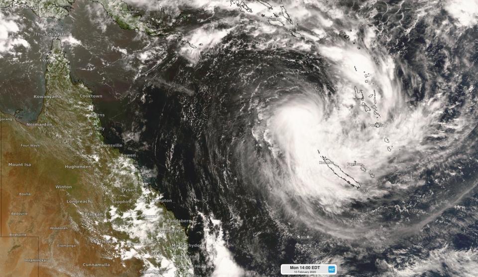
“If this happens, the remnants of Tropical Cyclone Uesi, most likely in the form of an extra-tropical cyclone, could cause direct impacts in eastern NSW or southeast Queensland.
“These impacts could include large and dangerous surf, strong winds and heavy rain.”
Rain and strong winds would only happen, however, if the system gets close enough to the coast, Weatherzone said.
On the other side of the country, the weather system that brought tropical cyclone Damien will continue to move east this week, producing more heavy rain on the west coast as it heads further inland.
By Wednesday the system will have weakened and it won’t bring rain to south Australia.
“The remnants of ex-tropical cyclone Damien unfortunately won’t make it into South Australia, with no real rain forecast,” Ms Legge said.
Even though Tropical #CycloneDamien is rapidly weakening, there are still hazards associated with it due to strong winds and heavy rain. Stay up to date with all warnings here; https://t.co/YGxjTMmwVH @dfes_wa pic.twitter.com/ZW7xK2TIRo
— Bureau of Meteorology, Western Australia (@BOM_WA) February 9, 2020
East coast deluge could see water restrictions eased
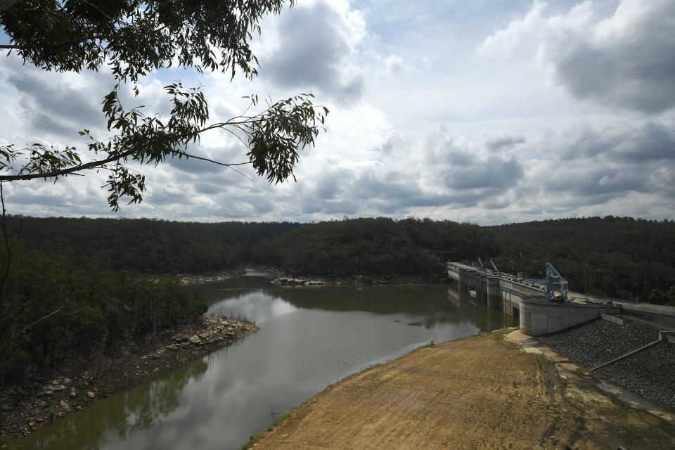
Sydney received about one third of its annual rainfall during the last four days as the heaviest rain in 30 years inundated the country’s biggest city.
This deluge helped recover nearly one and a half year’s worth of water losses in the Greater Sydney dams.
Dam levels across greater Sydney have risen by more than 20 percentage points amid heavy weekend rainfall, with enough water for as much as 150,000 Olympic-size swimming pools flowing into Warragamba Dam.
Here are the rainfall amounts in #NSW since 9am yesterday. The red dots indicate 100mm of rain PLUS. Totals are mind blowing. #Sydney has recorded the heaviest rain in nearly 3 DECADES from this event. What a summer of extremes. #NSWFloods @SkyWeatherAUS pic.twitter.com/cIGCtkMM6H
— Samantha Chiari (@samanthachiari) February 9, 2020
The Bureau of Meteorology suggested on Sunday that Sydney had not experienced such rainfall since before the new millennium.
Water NSW data on Monday morning showed that greater Sydney dam levels were at 64.2 per cent, up from 41.9 per cent in seven days.
Warragamba Dam recouped a year's worth of water in one weekend, rising 17.7 percentage points to sit at 60.7 per cent at 10.30am on Monday. Some 360,000 megalitres of water flowed into the dam - almost 150,000 swimming pools.
The dam this time last year was 61.4 per cent full.
The deluge of water over recent days isn’t enough to put an end to the drought but it does ease the burden when it comes to water-saving measures and means Sydney and surrounding regions will likely avoid level three water restrictions in the near term.
Level two water restrictions were brought in for Sydney, the Blue Mountains and the Illawarra in December last year, when combined water levels were about 45 per cent.
A decision is still reportedly being sought from NSW Minister for Water Melinda Pavey on whether restrictions will be eased in the wake of the extensive rainfall.
Do you have a story tip? Email: newsroomau@yahoonews.com.
You can also follow us on Facebook, Instagram and Twitter and download the Yahoo News app from the App Store or Google Play.


