
Wet weather and wild conditions to continue across eastern states
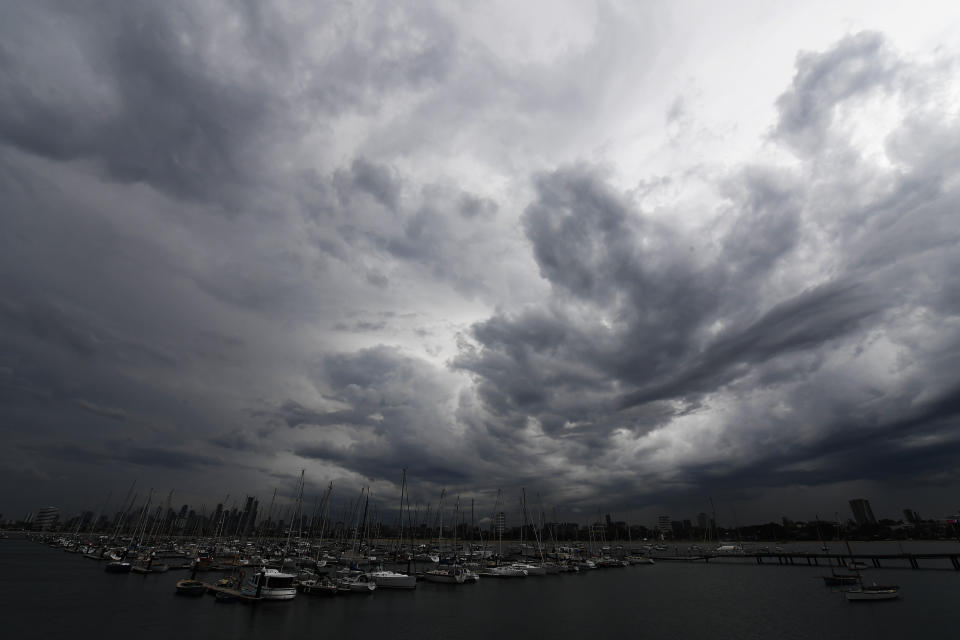
Intense rain has lashed Melbourne's outer eastern and southeastern suburbs, leading to flash flooding and fallen trees and cutting power to thousands of properties.
Parts of Victoria's Gippsland and La Trobe Valley also copped a drenching as severe thunderstorms hit the state on Friday.
The State Emergency Service had fielded 550 requests for help by 9.30pm Friday with 175 of them for flooding, 156 for building damage and 180 for trees that had come down.
The Bureau of Meteorology says rain has been particularly intense in the outer eastern suburbs of Croydon, Ringwood, Bayswater, Boronia, Ferntree Gully.
In the southeast, Narre Warren, Cranbourne, Beaconsfield and Berwick copped a drenching. Southeastern Cardinia recorded 63mm by 9pm, 42mm of which fell within half an hour, while nearby Officer received 50mm.
Thorpdale in Gippsland received 63mm and She Oaks near Geelong recorded 58mm. Meanwhile some small hail was recorded at Glen Iris and near the Melbourne Airport.
The conditions caused havoc for the city's power networks, with AusNet reporting about 12,000 of its customers were without power at about 4pm. That figure was down to 6000 by 8.30pm as crews worked through the night to restore power.
Meanwhile PowerCor reported more than 9000 customers without power at 7pm, which was down to 2500 by 8.30pm.
#Pakenham #vicweather #melbweather @BOM_Vic pic.twitter.com/bjMP1WSxAP
— theloneisobar (@DeanSgarbossa) February 14, 2020
Severe thunderstorm warning for parts of Victoria Saturday
The wet conditions are expected to weaken in the southeast of the state as they continue moving east over the weekend. However Victoria's northeast is forecast to experience severe thunderstorms on Saturday afternoon which may bring very heavy rainfall, large hail and damaging winds.
A Bureau of Meteorology said “thunderstorms are likely across much of eastern/northeastern Victoria this afternoon and are likely to be severe in parts” but has downgraded a severe weather warning previously in place.
Rain in the northeast could help temper bushfires still burning in the region.
"I think there will be some assistance – it is still hit and miss, so not a widespread rainfall event, but it will help generally," Bureau of Meteorology senior forecaster Michael Efron told AAP.
Thunderstorms are likely across much of eastern/northeastern Victoria this afternoon and are likely to be severe in parts. Keep up to date: https://t.co/HLs2UYFQyQ pic.twitter.com/BysddO0mDd
— Bureau of Meteorology, Victoria (@BOM_Vic) February 14, 2020
"That heavy rainfall actually could be a concern though in terms of flash flooding and landslides, just given the lack of education in those areas."
The State Emergency Service has urged people to remain alert, particularly those in fire-affected areas where heavy rain could pose the risk of landslides and debris strewn across roads.
"Flash floods can happen quickly, without warning and it is important to never enter or drive through flood waters, as it can take just 15cm of water to float a car," SES State Agency Commander David Baker said.

Rain forecast for Sydney, some beaches expected to close
More rain is expected to hit Sydney and parts of the east coast from Saturday afternoon as ex-tropical cyclone Uesi moves south through the Tasman Sea.
Rain and thunderstorm activity is expected through the bushfire-ravaged South Coast, the Southern Tablelands and western Sydney.
There’s a chance of a thunderstorm in Penrith, in Sydney’s west, hitting the area late in the afternoon with up to 10mm of rain.
Flood warnings also remain in place after the weekend's wet weather deluge, particularly through the NSW Mid North Coast.

Flash flooding may also occur in the Tweed, Richmond, Wilson, Clarence, Bellinger, Macleay, Upper Nepean, Wyong, Tuggerah, Orara, Gwydir, Castlereagh, Paroo, Nambucca and Weir rivers.
Ausgrid repair crews will continue working across the weekend to restore power to around 9700 customers still affected by last weekend's storm damage.
More than 130,000 homes and business have been reconnected, with all works expected to be completed by Sunday.
A hazardous surf warning is in place for the Hunter, Sydney, Illawarra, Batemans Bay and Eden on Saturday.

Surf Life Saving NSW warned rock fishers, boaters, surfers and swimmers to stay away from the water.
"If people don't heed emergency service warnings and put themselves in danger in these extreme conditions, it's possible that lifesavers will not be able to save them," lifesaving director Joel Wiseman said in a statement on Friday.
Some beaches may be closed on the weekend due to the large swell, poor water quality and large amounts of debris in the water caused by wind gust from ex-cyclone Uesi.
Flooded Queensland set for more rain
Meanwhile more rain is set to falls across Queensland this weekend as parts of the state continue to mop up after a major downpour.
Storms are possible for large parts of eastern Queensland on Saturday afternoon, but nothing like the deluge over the past few weeks, Bureau of Meteorology forecaster Kimba Wong said.
Isolated heavy rainfall is possible for coastal areas south of the Whitsunday islands.
⛈️ SATURDAY STORM FORECAST ⛈️
Isolated, slow-moving storms with heavy rainfall possible for central & southeast Qld. Seasonal storms in the north; chance of severe storms with locally damaging winds in the Gulf Country. Warnings issued as required https://t.co/FBmpsInT9o pic.twitter.com/dQRjZzE2jY— Bureau of Meteorology, Queensland (@BOM_Qld) February 15, 2020
Days of heavy rain in the southeast corner of the state have led to flooding that is just starting to subside.
Northern Queensland can expected showers and thunderstorms to break a severe heatwave.
Do you have a story tip? Email: newsroomau@yahoonews.com.
You can also follow us on Facebook, Instagram and Twitter and download the Yahoo News app from the App Store or Google Play.

