
'Drastic' change to bring wet weather and cold temperatures
The streak of summer-like conditions has come to an abrupt end as heavy rainfall bears down on the east coast, which will be accompanied by a significant drop in temperature.
Up to 50 millimetres of rain could be dumped in New South Wales within the next 24 hours, with the biggest downpour likely to hit the Hunter Coast, according to Weatherzone meteorologist Craig McIntosh.
“We’ve got a trough that’s passing over NSW and a cold front behind it. A frontal system is passing over eastern NSW currently and a low is forming within a trough offshore,” Mr McIntosh told Yahoo News Australia.
“What that will do is direct the rainfall to the coast, and anywhere south of the low, which will be developing off the mid north coast.”
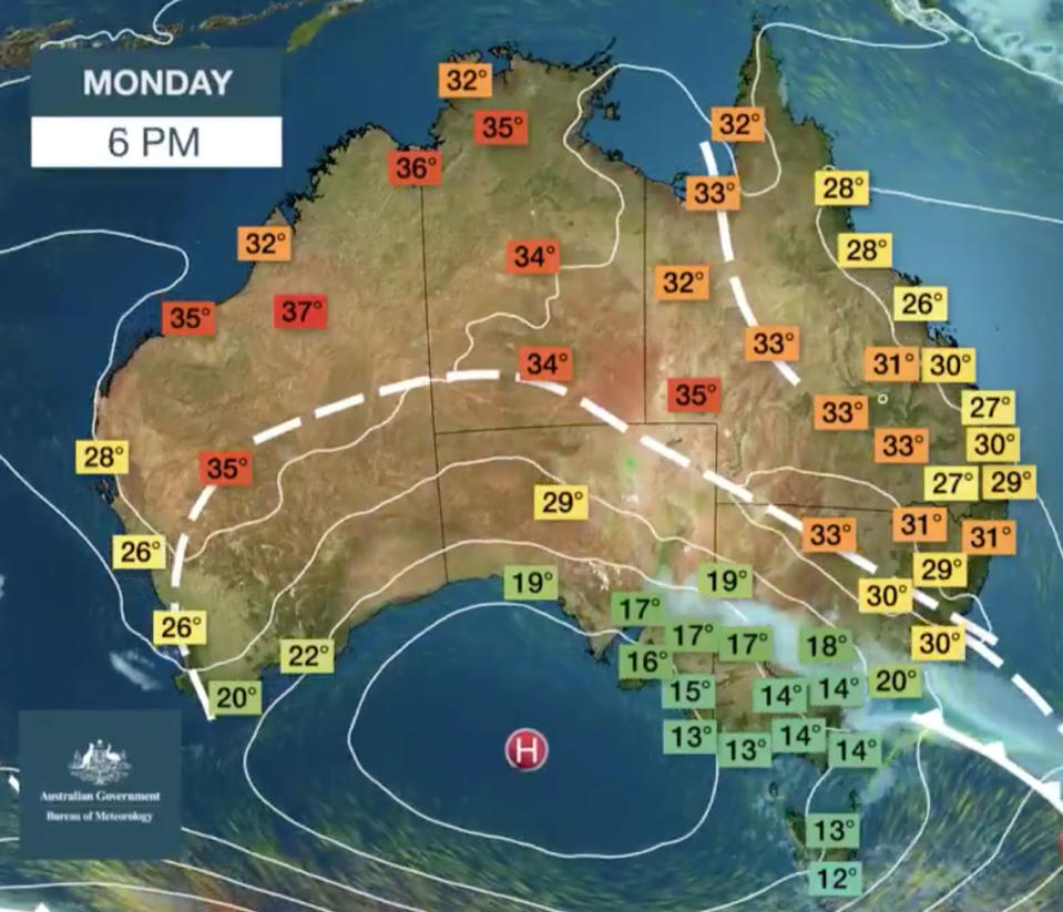
“That means the heaviest rainfall would be south from the mid north coast to heaviest down around the south coast, all the way down to Merimbula.”
Mr McIntosh said between Monday afternoon and Tuesday evening, Sydney could receive between 25 and 50 millimetres.
“The heaviest falls will probably be around the Hunter Coast and possibly a bit in the Hunter Valley,” he said.
Despite it being a sudden and dramatic change to the warmth experienced in previous weeks, Mr McIntosh said it wasn’t entirely unusual.
Lingering colder air masses to the south and the warming temperatures up north are to blame for such significant changes, he said.
“This time of year you will see dramatic changes one day to the other due to that air mass being dragged down to the south.”
“It’s not out of character and it will happen a couple of times in the season, but not all changes are this drastic.”
Rain (and snow) is starting to set in over SE NSW as cold, southerly air pushes under and lifts a mid level cloud band. pic.twitter.com/c7Lrc8MKdP
— Andrew Miskelly (@andrewmiskelly) September 16, 2019

The last significant dump of rain in Sydney was on August 30, when the city received 43 millimetres in one day.
The Bureau of Meteorology has indicated the wet conditions will stick around until Thursday, with showers easing for Friday before returning for the weekend.
Melbourne on the other hand will be wet for the remainder of Monday, but stay dry until Friday and then should expect rain throughout the weekend.
Other than a slight chance of rain on Tuesday and Saturday, Brisbane will be warm and dry for the coming week, with temperatures in the mid to high 20s expected.
Our meteorologist Miriam Bradbury presents next week's weather forecast as aired today on ABC Landline. Our forecasts update daily, please visit https://t.co/4W35o8i7wJ for current information. pic.twitter.com/fA7eEAjo1l
— Bureau of Meteorology, Australia (@BOM_au) September 15, 2019
A storm is expected for Wednesday and rain on Thursday for Perth, which will otherwise see a continuation of fine conditions in the high teens and low 20s.
Adelaide will have a wet remainder of its Monday before a few dry days and rain again on Friday and Saturday, which is expected to clear for Sunday.
Rain will linger in Hobart through Monday before clearing until Friday and sticking around for a wet weekend.
Canberra is expected to be rainy for the rest of its Monday and early Tuesday, before being mostly fine until the weekend.
The Northern Territory’s capital will completely avoid the wet conditions and hover in the low 30s for the coming week.
Do you have a story tip? Email: newsroomau@yahoonews.com.
You can also follow us on Facebook and Twitter, download the Yahoo News app from the App Store or Google Play and stay up to date with the latest news with Yahoo’s daily newsletter. Sign up here.
