'Intense rain': Australia's east coast to get 48-hour soaking
Australia’s east coast is set for a drenching this week as ex-tropical cyclone Esther brings “intense” rain from central parts of the Northern Territory to NSW’s southeast coast.
Esther has eased into a weaker tropical low which on Tuesday was sitting over the northwest of the Northern Territory, and was expected to traverse across central parts of Queensland and NSW throughout Wednesday and Thursday.
Tropical moisture was set to be drawn into another system due to affect central parts of the Northern Territory to southwestern Queensland and northern parts of NSW, Weatherzone meteorologist Felix Levesque told Yahoo News Australia.
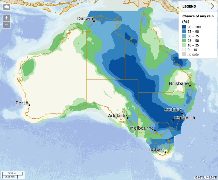
He said between 50 to 100mm of rain could be expected for a broad scale area stretching from central Northern Territory, all the way to south eastern parts of NSW, including drought-affected areas in the west.
“Along the fringes we’ll see anywhere from 10 to 50mm,” Mr Levesque said.
Australian summers now a month longer – and the trend is set to continue
'It's quite startling': Before-and-after images show impact of rain dumping
Alarming satellite images of Antarctica reveal extreme melting event
Between 10mm and 20mm is expected to fall in Sydney throughout Wednesday and Thursday, the days predicted to experience the “more intense” rain.
“It will being rainfall to inland parts like western NSW which has been affected by drought.”
While some significant rain is on the cards, the forecast is nowhere close to the downpour that slammed the country early in February, that extinguished bushfires but caused catastrophic flooding.
Northern parts of Victoria, its northeast and the Alps may also experience between 50mm and 100mm of rain, Mr Levesque said.
“In Melbourne there will definitely be an effect of this system, but it’s going to be more subdued. There probably won’t be more than five or 10mm in the city,” he said.
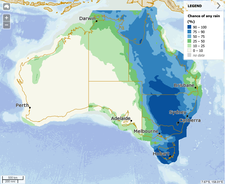
Rainfall relating to the band of precipitation stretching from central Northern Territory to southeast NSW was expected to subside by Friday, however there will be small amounts of rain throughout the weekend.
The Bureau of Meteorology issued severe weather warnings for six states and territories on Tuesday as the remnants of Esther continues its southeasterly move.
Adelaide is expected to remain clear throughout the week with temperatures hovering in the mid-20s through until Sunday.
Severe Weather Warnings are current across 6 states and territories as the remnants of ex-TC Esther continue moving south east, bringing damaging winds and heavy rainfall. Check the latest severe weather and flood warnings here https://t.co/hYvXfx3MXk pic.twitter.com/KwXDKjIEmG
— Bureau of Meteorology, Australia (@BOM_au) March 3, 2020
Hobart will be fine until Thursday, then have rain each day until Saturday while remaining in the high teens and low 20s.
In Canberra there is expected to be rain each day until Monday next week, with up to 80mm expected to fall on the country’s capital on Wednesday.
Perth’s fine weather appears to be continuing with no rain forecast, and temperatures between 29 and 32 predicted for the rest of the week.
Do you have a story tip? Email: newsroomau@yahoonews.com.
You can also follow us on Facebook, Instagram and Twitter and download the Yahoo News app from the App Store or Google Play.